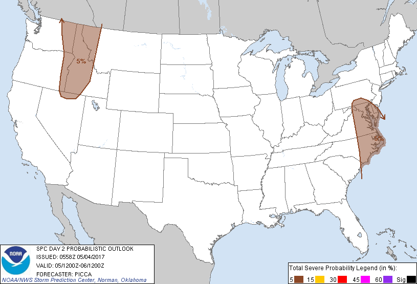
Baltimore, MD...Washington, DC...Virginia Beach, VA...Raleigh, NC...Norfolk, VA...
Probabilistic Graphic
Probability of severe weather within 25 miles of a point. Hatched Area: 10% or greater probability of significant severe within 25 miles of a point.
Day 2 Prob. Risk
Area (sq. mi.)
Area Pop.
Some Larger Population Centers in Risk Area
5 %
176,899
19,173,921
Baltimore, MD...Washington, DC...Virginia Beach, VA...Norfolk, VA...Chesapeake, VA...
SPC AC 040558
Day 2 Convective Outlook
NWS Storm Prediction Center Norman OK
1258 AM CDT Thu May 04 2017
Valid 051200Z - 061200Z
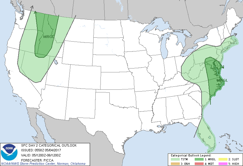
...THERE IS A MARGINAL RISK OF SEVERE THUNDERSTORMS ACROSS PARTS OF
THE MID-ATLANTIC...
...THERE IS A MARGINAL RISK OF SEVERE THUNDERSTORMS ACROSS PARTS OF
THE INTERIOR PACIFIC NORTHWEST...
...SUMMARY...
A few strong/severe thunderstorms are possible across the
Mid-Atlantic Friday morning into the afternoon hours. Elsewhere,
isolated strong to briefly severe storms will be possible through
the evening across the interior Pacific Northwest.
...Synopsis...
Expansive mid-level low pressure will slowly progress east towards
the southern Appalachians, before opening and lifting northeast
towards the Mid-Atlantic as an upstream shortwave trough translates
south across the upper Great Lakes. An upstream ridge will be
positioned over the southern/central Rockies and northern High
Plains, while an amplified trough moves ashore the Pacific Northwest
coast.
...Portions of the Mid-Atlantic...
Aided by an approximately 50-kt low-level jet, a band of showers and
thunderstorms will likely be pushing east towards the Mid-Atlantic
coast Friday morning. Ahead of this convection, southerly flow will
transport a relatively moist air mass (characterized by surface dew
points generally in the mid 60s) northward towards Maryland and
southern Pennsylvania. This warm/moist sector will be narrowing as
convection spreads east, becoming displaced from stronger
large-scale ascent to the west. Nonetheless, weak/modest
surface-based buoyancy will develop northward, such that fairly
strong low-level and deep-layer shear will likely support a few
stronger bands of convection, capable of isolated damaging gusts and
perhaps a brief tornado during the first part of the day.
Thereafter, it is possible isolated thunderstorms develop farther
west and northwest closer to a surface trough/front and colder
mid-level temperatures. These storms would be capable of some small
hail and gusty winds, but convective overturning, limited heating
(due to prior precipitation), and drying mid levels make the
potential for re-development more uncertain.
...Portions of the interior Pacific Northwest...
As mid-level heights fall with the approach of a trough, small-scale
perturbations embedded in southerly flow and orographic influences
are expected to foster organizing convection from northern Nevada to
the northern Rockies Friday. Across western/northern portions of the
Marginal Risk area, early-day convection and cloud cover may slow
diurnal heating, reducing the potential for strong/severe storms.
However, modest heating and sufficient low/mid-level moisture should
foster MLCAPE upwards of 500-750 J/kg across parts of the region.
Storms will organize along higher terrain through the day and then
advance north/northeast within a zone of 35-50 kt of mid-level flow.
Dry sub-cloud layers and favorable convective-layer momentum will
potentially yield a few strong to briefly severe storms capable of
isolated damaging winds.
..Picca.. 05/04/2017
CLICK TO GET WUUS02 PTSDY2 PRODUCT
NOTE: THE NEXT DAY 2 OUTLOOK IS SCHEDULED BY 1730Z