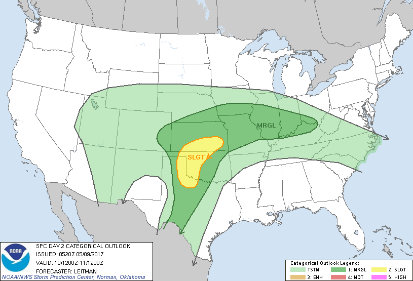
Wichita, KS...Enid, OK...Hutchinson, KS...Emporia, KS...Ponca City, OK...
MARGINAL
326,173
24,788,598
Indianapolis, IN...Oklahoma City, OK...Kansas City, MO...Omaha, NE...Tulsa, OK...
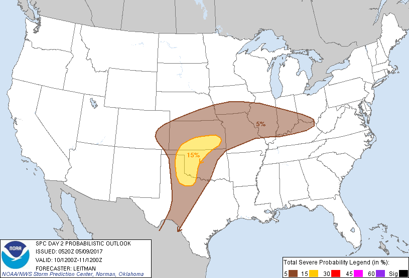
Probabilistic Graphic
Probability of severe weather within 25 miles of a point. Hatched Area: 10% or greater probability of significant severe within 25 miles of a point.
Day 2 Prob. Risk
Area (sq. mi.)
Area Pop.
Some Larger Population Centers in Risk Area
15 %
66,152
1,481,374
Wichita, KS...Enid, OK...Hutchinson, KS...Emporia, KS...Ponca City, OK...
5 %
327,550
24,821,759
Indianapolis, IN...Oklahoma City, OK...Kansas City, MO...Omaha, NE...Tulsa, OK...
   SPC AC 090520

   Day 2 Convective Outlook
   NWS Storm Prediction Center Norman OK
   1220 AM CDT Tue May 09 2017

   Valid 101200Z - 111200Z

   ...THERE IS A SLIGHT RISK OF SEVERE THUNDERSTORMS ACROSS PORTIONS OF
   THE CENTRAL AND SOUTHERN PLAINS...

   ...THERE IS A MARGINAL RISK OF SEVERE THUNDERSTORMS SURROUNDING THE
   SLIGHT RISK FROM THE SOUTHERN PLAINS TO THE MID-MISSISSIPPI AND
   LOWER OHIO VALLEY REGIONS...

   ...SUMMARY...
   Severe storms will be possible across parts of the southern/central
   Plains Wednesday into Wednesday night. Isolated strong/severe storms
   may also be possible across parts of the mid-Mississippi and Ohio
   Valleys.

   ...Synopsis...
   A closed upper low over AZ/NM Wednesday morning will progress
   eastward toward the southern High Plains by 00z Thursday. Strong
   deep-layer mid and upper level southwesterly flow will overspread
   the region from far southwest TX into OK/KS. Further east, an upper
   ridge centered on the MS River will shift east. As this occurs, a
   shortwave impulse tracking east across the upper Mississippi Valley
   and Great Lakes will flatten the ridge, resulting in weak height
   falls from IA to the lower Ohio Valley.

   ...Southern/Central Plains...

   Convection will be ongoing across parts of the TX Panhandle and
   western OK at the beginning of the period. This convection likely
   will be elevated and pose mainly a large hail threat, though,
   depending on convective mode and evolution, a wind threat could also
   be ongoing in any bowing segments.

   This early convection will be a fly in the ointment for later
   development in the afternoon along the dryline, which is expected to
   surge eastward as a shortwave impulse ejects northeast from NM into
   the TX Panhandle by late afternoon. Strong warm advection around
   850-700mb will maintain capping once initial round of morning
   convection passes. As the upper shortwave approaches, forecast
   soundings suggest that capping will weaken sufficiently and isolated
   storms may initiate along the dryline near the TX Panhandle/western
   OK border. Various deterministic guidance show some weakness in flow
   between 850-700mb during the afternoon/early evening, in addition to
   a veer-back-veer kinematic profile, which together may play a role
   in organization/intensity of any convection that develops. At this
   time, large hail appears to be the main threat with strong deep
   layer shear and steep midlevel lapse rates present. However, backed
   low-level flow in the lowest 3km and sufficient low-level moisture
   could also support a tornado or two in better organized/stronger
   cells.

   The north and eastward extent of the severe threat remains in
   question given aforementioned uncertainty due to early convection,
   capping, and any additional early convection in strong warm
   advection regime across OK/KS. Given many question marks, will
   maintain slight risk designation.

   ...Central Plains to Ohio Valley...

   A cold front will be positioned from near northeast CO into central
   NE at the beginning of the period and drop south/southeast across
   the central Plains and upper MS Valley through the afternoon.
   Meanwhile, a warm front will lift northward across IA/IL and the
   lower OH Valley region. As the Great Lakes shortwave flattens the
   upper ridge and increases forcing for ascent, widespread convection
   is expected to develop along/ahead of these boundaries. Weak to
   moderate instability and modest midlevel lapse rates in the presence
   of adequate deep-layer shear should be sufficient for a hail threat.
   While some instances of severe hail will be possible, storm mode
   /mainly clusters with some linear segments/ appears to be the
   limiting factor for any higher probs at this time.

   ..Leitman.. 05/09/2017

   CLICK TO GET WUUS02 PTSDY2 PRODUCT

   NOTE: THE NEXT DAY 2 OUTLOOK IS SCHEDULED BY 1730Z