SPC AC 011703
Day 2 Convective Outlook
NWS Storm Prediction Center Norman OK
1203 PM CDT Thu Jun 01 2017
Valid 021200Z - 031200Z
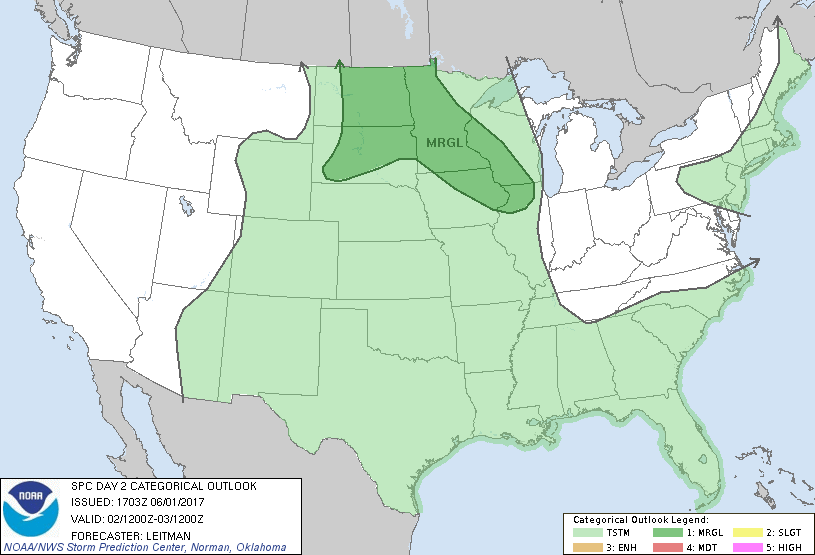
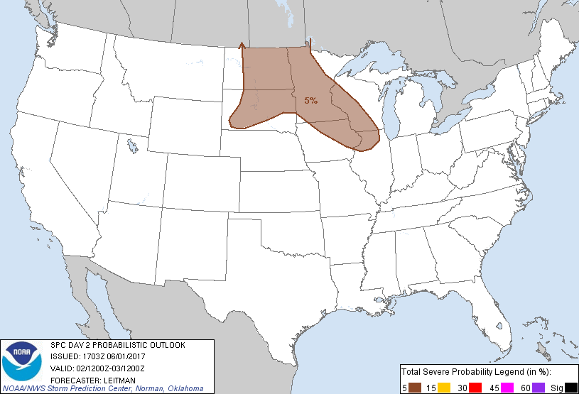
...THERE IS A MARGINAL RISK OF SEVERE THUNDERSTORMS ACROSS PORTIONS
OF THE NORTHERN PLAINS TO THE UPPER MISSISSIPPI VALLEY...
...SUMMARY...
Marginally severe thunderstorms with strong wind gusts and hail will
be possible Friday afternoon and evening across parts of the
northern Plains and upper Mississippi Valley.
...Northern Plains to the Upper MS Valley...
An upper ridge will reside over the Plains Friday morning. Beneath
the ridge, southerly low level flow will maintain low to mid 60s
dewpoints across portions of the Dakotas and the upper MS Valley
vicinity. A shortwave trough over the northern Rockies will shift
northeast through the day and traverse the northern Plains after
00z. Meanwhile, a surface cold front associated with a low over the
Canadian prairie provinces will shift east across the northern
Plains during the afternoon and evening hours. Strong heating ahead
of this boundary will result in moderate to strong instability and
thunderstorms are expected to develop across the western/central
Dakotas by mid to late afternoon. Deep layer shear will be rather
weak, on the order of 20-30 kts, and this will limit overall storm
organization. However, steep midlevel lapse rates and SBCAPE values
greater than 2000 J/kg should be sufficient for isolated strong to
marginally severe storms through the evening hours. Hail will be the
main concern, though if storms can organize into any linear/bowing
segments along the front or through outflow interactions, a wind
threat could temporarily increase.
Further east, additional strong to marginally severe thunderstorms
will be possible across portions of MN, WI, IA and IL. Isolated
diurnally driven storms will be possible, though weak forcing
beneath the eastward progressing upper ridge and weak vertical wind
profiles should limit intensity/coverage of any afternoon storms.
Later in the evening/overnight hours, height falls across the region
will occur with the approach of the upper shortwave trough and 850mb
flow will increase. Thunderstorms are then expected to develop along
a moist axis from northern MN into WI and possible eastern IA and
northern IL. Modest lapse rates approaching 7 deg C/km and weak to
moderate instability could support a few marginally severe
thunderstorms capable of mainly small hail.
..Leitman.. 06/01/2017
CLICK TO GET WUUS02 PTSDY2 PRODUCT
NOTE: THE NEXT DAY 2 OUTLOOK IS SCHEDULED BY 0600Z