SPC AC 030520
Day 2 Convective Outlook
NWS Storm Prediction Center Norman OK
1220 AM CDT Sat Jun 03 2017
Valid 041200Z - 051200Z
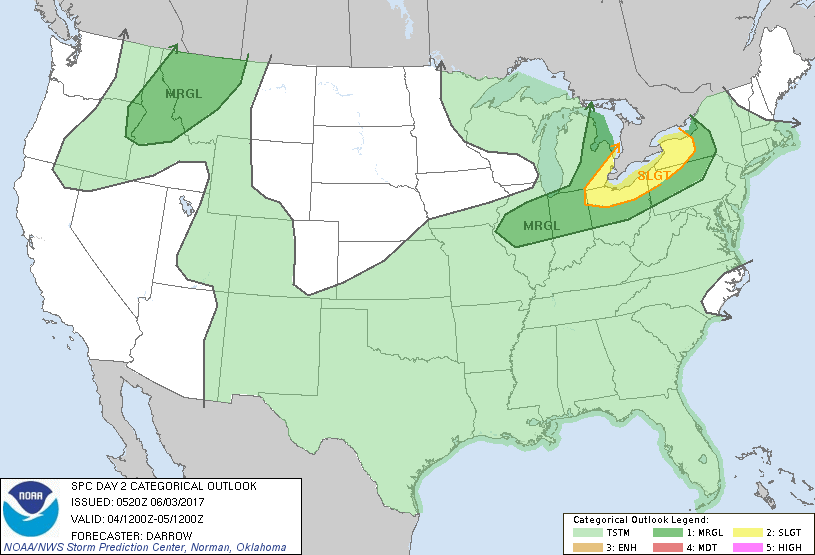
...THERE IS A SLIGHT RISK OF SEVERE THUNDERSTORMS OVER PORTIONS OF
THE LOWER GREAT LAKES...
...THERE IS A MARGINAL RISK OF SEVERE THUNDERSTORMS ACROSS PARTS OF
THE OH VALLEY AND GREAT LAKES...
...THERE IS A MARGINAL RISK OF SEVERE THUNDERSTORMS OVER THE
NORTHERN ROCKIES...
...SUMMARY...
Scattered strong/severe thunderstorms are expected across the Ohio
Valley and adjacent lower Great Lakes region. Isolated severe
thunderstorms are also possible across the northern Rockies.
...OH Valley/Lower Great Lakes...
Upper heights are expected to lower across the Great Lakes during
the day2 period as mid-level troughing begins to establish itself
over the northeastern US. In response to this evolving trough, a
surface low is expected to track across northern lower MI into far
western NY by 05/00z. Deepening westerly flow across the Great Lakes
and OH Valley suggest low-level lapse rates will steepen due to
strong boundary-layer heating ahead of a synoptic front. Latest
model guidance suggests the primary zone of low-level confluence
should extend from lower MI, southwest into central IL at 18z and
this boundary should sag south into the OH Valley by early evening.
Large-scale forcing for ascent will spread into the lower Great
Lakes which should encourage robust convective development within a
corridor of strong deep-layer shear. Forecast soundings near Lake
Erie exhibit SBCAPE on the order of 2000 J/kg with shear profiles
favoring organized line segments. Damaging winds and hail are the
primary threats with convection that evolves along the cold front.
...Northern Rockies...
Strong mid-level short-wave trough will move inland across
OR/northern CA around 18z then eject toward the northern Rockies by
05/12z. Ahead of this feature, south-southwesterly flow will
increase at 500mb such that shear profiles will become increasingly
supportive of organized convection by late afternoon, especially
from portions of ID into western MT. Strongest convection will
likely evolve over the northern Rockies where buoyancy is expected
to be maximized with MUCAPE on the order of 1000 J/kg. Convection
that evolves over the higher terrain of ID/western MT should track
northeast producing strong winds and hail.
..Darrow.. 06/03/2017
CLICK TO GET WUUS02 PTSDY2 PRODUCT
NOTE: THE NEXT DAY 2 OUTLOOK IS SCHEDULED BY 1730Z