Jacksonville, FL...Denver, CO...Miami, FL...Colorado Springs, CO...Tampa, FL...
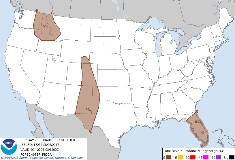
Probabilistic Graphic
Probability of severe weather within 25 miles of a point. Hatched Area: 10% or greater probability of significant severe within 25 miles of a point.
Day 2 Prob. Risk
Area (sq. mi.)
Area Pop.
Some Larger Population Centers in Risk Area
5 %
301,479
25,326,324
Jacksonville, FL...Denver, CO...Miami, FL...Colorado Springs, CO...Tampa, FL...
SPC AC 061726
Day 2 Convective Outlook
NWS Storm Prediction Center Norman OK
1226 PM CDT Tue Jun 06 2017
Valid 071200Z - 081200Z
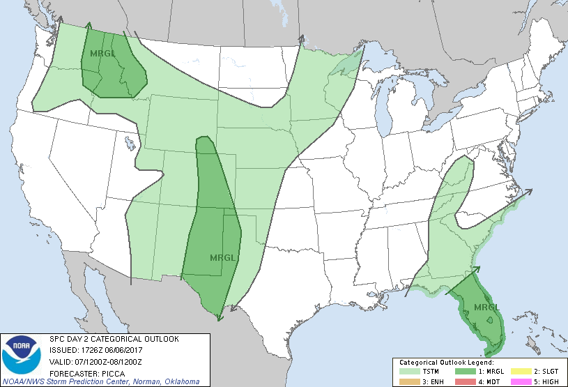
...THERE IS A MARGINAL RISK OF SEVERE THUNDERSTORMS ACROSS PORTIONS
OF THE FL PENINSULA...
...THERE IS A MARGINAL RISK OF SEVERE THUNDERSTORMS ACROSS PORTIONS
OF THE SOUTHERN/CENTRAL HIGH PLAINS...
...THERE IS A MARGINAL RISK OF SEVERE THUNDERSTORMS ACROSS PORTIONS
OF THE NORTHERN ROCKIES...
...SUMMARY...
A few severe thunderstorms will be possible across portions of the
Florida Peninsula, the southern/central High Plains, and the
northern Rockies Wednesday into Wednesday night.
...Synopsis...
General cyclonic mid-level flow will persist across the eastern US
Wednesday, as a positively tilted trough continues to shear along an
axis from the central Appalachians to the Canadian Maritimes.
Farther south, a weaker impulse will continue to slowly advance east
across the central/eastern Gulf Coast. Across the central US and
Intermountain West, broad ridging will remain in place, although
several weak/subtle impulses will likely crest the ridge and drop
southeast across portions of the High Plains. Meanwhile, a rather
amplified trough will approach the Pacific Northwest coast overnight
Wednesday.
...Portions of the Florida Peninsula...
The persistence of the large-scale pattern over the eastern US will
maintain a west/southwesterly sub-tropical jet over parts of Florida
on Wednesday. Embedded within this jet, weak perturbations will
likely foster waves of convection moving onshore the Florida
Peninsula through the day. As such, broad shields of precipitation
will temper boundary-layer destabilization, limiting the severe
threat some. Nonetheless, with a broad corridor of southwesterly
850mb winds around 30-40kt, adequate low-level flow/shear may be
conducive to a few rotating updrafts, capable of locally damaging
winds and perhaps a tornado on Wednesday.
...Portions of the southern/central High Plains...
Similar to the previous day, modest north/northwesterly mid-level
flow will continue along the northeastern periphery of a ridge
centered over parts of the Rockies. Broad southeasterly, upslope
flow will likely maintain/transport surface dew points in the 50s to
near 60 over the southern/central High Plains. In turn, as
convection develops off higher terrain and slowly spreads southeast,
it will encounter an environment generally characterized by a
well-mixed boundary layer and MLCAPE values around 1000-1500 J/kg.
Effective shear values around 25-30 kt may yield temporary/transient
organization of cells, promoting a few instances of large hail.
Gusty/locally damaging winds will also be possible, with ample
sub-cloud evaporation expected.
...Portions of the northern Rockies...
Mid-level heights will slowly fall late in the period, as a ridge
builds east and a trough approaches the Pacific Northwest.
Southwesterly flow aloft will gradually increase through the period,
in response to the approaching trough. While such an influence does
appear to be rather late in the period (casting some doubt on the
potential for severe storms), convection organizing along higher
terrain late will exist within an environment characterized by steep
low-level lapse rates and adequate mixed-layer CAPE. In turn, any
stronger cells that evolve northeastward may be capable of strong,
gusty winds and perhaps marginally severe hail.
..Picca.. 06/06/2017
CLICK TO GET WUUS02 PTSDY2 PRODUCT
NOTE: THE NEXT DAY 2 OUTLOOK IS SCHEDULED BY 0600Z