SPC AC 080538
Day 2 Convective Outlook
NWS Storm Prediction Center Norman OK
1238 AM CDT Thu Jun 08 2017
Valid 091200Z - 101200Z
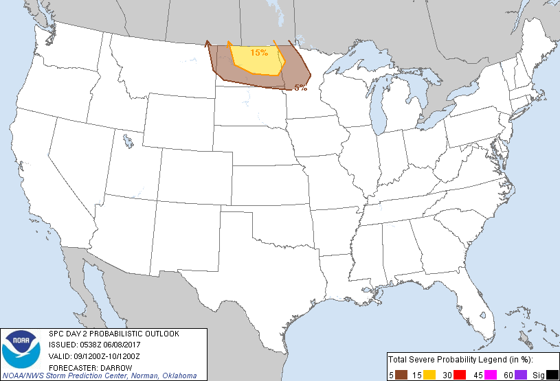
...THERE IS A SLIGHT RISK OF SEVERE THUNDERSTORMS ACROSS PORTIONS OF
THE NORTHERN PLAINS...
...THERE IS A MARGINAL RISK OF SEVERE THUNDERSTORMS FROM EXTREME
EASTERN MT TO NORTHWEST MN...
...SUMMARY...
Strong/severe thunderstorms are possible across the northern Plains
Friday. Hail/wind are the primary threats.
...Northern Plains...
A belt of strong mid-level flow, in excess of 60kt at 500mb, will
translate inland across the Great Basin into the northern High
Plains by the end of the period. This should flatten the dominant
upper ridge currently in place across the High Plains as an apparent
short-wave trough ejects across eastern MT into western ND Friday
night. In response to this feature, lee cyclone will be shunted off
the northern Rockies to a position over southwestern ND by mid
afternoon. Strong boundary layer heating is expected across the
Plains where surface-3km lapse rates should approach dry adiabatic
as temperatures warm into the 90s. While surface parcels should
approach their convective temperatures along the lee trough, it
appears thunderstorms will struggle to develop south of the warm
front as upper ridging and a plume of very warm air at 700mb
suppress thunderstorm activity. However, strong low-level warm
advection near the international border, along with more impact from
aforementioned short wave, is expected to induce convection across
southeast SK and southern MB which should propagate southeast within
warm advection corridor into the northern Red River Valley. Large
hail and damaging winds are the primary risks with this activity.
..Darrow.. 06/08/2017
CLICK TO GET WUUS02 PTSDY2 PRODUCT
NOTE: THE NEXT DAY 2 OUTLOOK IS SCHEDULED BY 1730Z