Philadelphia, PA...Baltimore, MD...Washington, DC...Newark, NJ...Jersey City, NJ...
SLIGHT
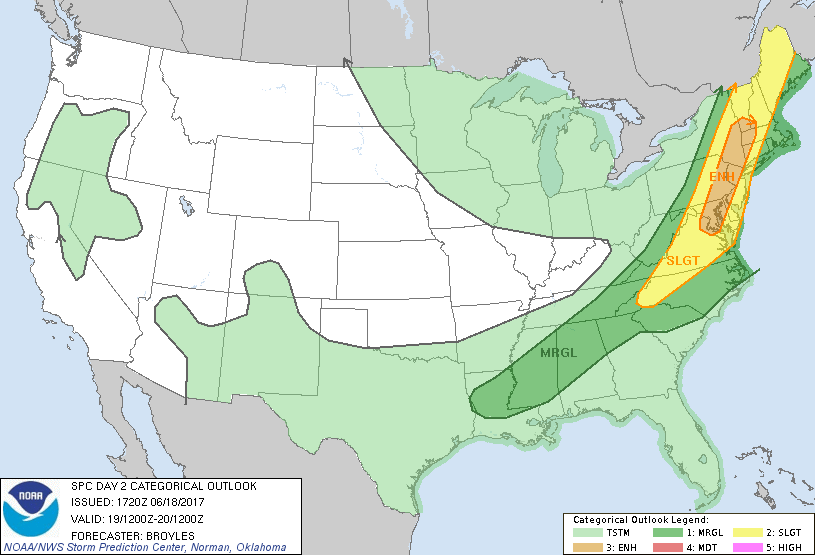
127,370
30,978,484
New York, NY...Greensboro, NC...Winston-Salem, NC...Richmond, VA...Worcester, MA...
MARGINAL
229,857
34,160,619
Charlotte, NC...Boston, MA...Virginia Beach, VA...Atlanta, GA...Raleigh, NC...
Probabilistic Graphic
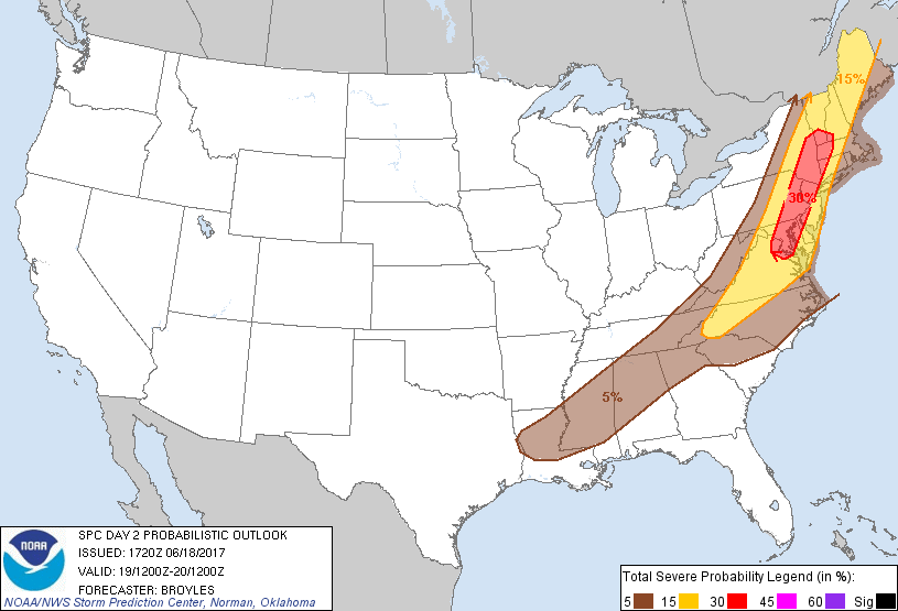
Probability of severe weather within 25 miles of a point. Hatched Area: 10% or greater probability of significant severe within 25 miles of a point.
Day 2 Prob. Risk
Area (sq. mi.)
Area Pop.
Some Larger Population Centers in Risk Area
30 %
35,766
25,370,759
Philadelphia, PA...Baltimore, MD...Washington, DC...Newark, NJ...Jersey City, NJ...
15 %
126,986
30,909,418
New York, NY...Greensboro, NC...Winston-Salem, NC...Richmond, VA...Worcester, MA...
5 %
229,009
34,160,293
Charlotte, NC...Boston, MA...Virginia Beach, VA...Atlanta, GA...Raleigh, NC...
   SPC AC 181720

   Day 2 Convective Outlook
   NWS Storm Prediction Center Norman OK
   1220 PM CDT Sun Jun 18 2017

   Valid 191200Z - 201200Z

   ...THERE IS AN ENHANCED RISK OF SEVERE THUNDERSTORMS ACROSS PARTS OF
   THE MID-ATLANTIC AND SOUTHWEST NEW ENGLAND...

   ...THERE IS A SLIGHT RISK OF SEVERE THUNDERSTORMS OUTSIDE OF THE
   ENHANCED RISK AREA FROM WESTERN NORTH CAROLINA TO NEW ENGLAND...

   ...THERE IS A MARGINAL RISK OF SEVERE THUNDERSTORMS OUTSIDE OF THE
   SLIGHT RISK AREA FROM THE LOWER MISSISSIPPI VALLEY INTO THE CENTRAL
   AND NORTHERN APPALACHIANS...

   ...SUMMARY...
   Scattered strong to severe thunderstorms are possible across
   portions of the Northeast into the Mid-Atlantic states Monday
   afternoon into the early evening.  Damaging wind gusts will be the
   primary severe hazard but large hail is also possible.

   ...Mid-Atlantic/New England/Western North Carolina...
   An upper-level trough will move across the Great Lakes and Ohio
   Valley on Monday as southwesterly mid-level flow remains over the
   Northeast. At the surface, a cold front will advance eastward across
   the lower Great Lakes and Ohio Valley. Ahead of this front, surface
   dewpoints in the mid to upper 60s F should result in a corridor of
   moderate instability from the Carolinas north-northeastward into the
   Mid-Atlantic. Thunderstorm development should take place along the
   front during the morning with a gradual expansion of convective
   coverage taking place in the afternoon. Several line segments may
   organize along the front moving to the coast of the Mid-Atlantic by
   early evening.

   At mid-levels, a 60 to 75 kt mid-level jet will move northeastward
   across the central Appalachians on Monday. Lift and deep-layer shear
   is forecast to be maximized on the southeastern edge of the
   mid-level jet where the greatest severe threat is expected Monday
   afternoon. NAM forecast soundings at 21Z from eastern Virginia to
   southeastern New York show MLCAPE from 1200 to 1800 J/kg with
   south-southwest flow at the surface and very gradually veering winds
   with height in the low to mid-levels. This wind profile with 0-6 km
   shear of 30 to 40 kt will support severe multicell line segments
   capable of producing damaging wind gusts. The faster moving short
   bowing line segments may produce longer swaths of wind damage mainly
   from Maryland north-northeastward into far southwest New England
   where the enhanced risk has been maintained. The potential for
   damaging wind gusts should be more isolated from central Virginia
   into western North Carolina where large-scale ascent is forecast to
   be considerably less than in areas to the north. Isolated large hail
   could also occur with the stronger updrafts along the front.

   ...Lower Mississippi Valley/Gulf Coast States/Northern Georgia...
   The southern extension of an upper-level trough will move across the
   Tennessee Valley on Monday as a cold front advances southward across
   the region. To the south of the front, surface dewpoints should be
   in the lower to mid 70s F resulting in moderate instability in most
   areas by midday. Thunderstorm development should take place along
   the front during the afternoon. The moderate instability combined
   with steep low-level lapse rates and weak deep-layer shear should be
   enough for isolated wet downbursts associated with pulse storms near
   peak heating.

   ..Broyles.. 06/18/2017

   CLICK TO GET WUUS02 PTSDY2 PRODUCT

   NOTE: THE NEXT DAY 2 OUTLOOK IS SCHEDULED BY 0600Z