SPC AC 271723
Day 2 Convective Outlook
NWS Storm Prediction Center Norman OK
1223 PM CDT Tue Jun 27 2017
Valid 281200Z - 291200Z
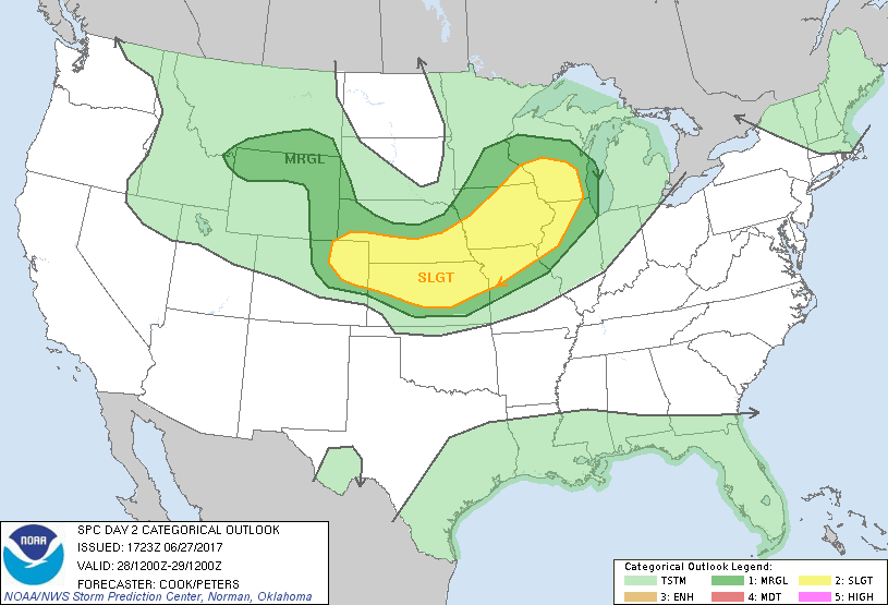
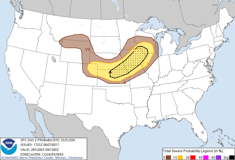
...THERE IS A SLIGHT RISK OF SEVERE THUNDERSTORMS FROM NORTHEASTERN
COLORADO INTO IOWA AND CENTRAL WISCONSIN...
...THERE IS A MARGINAL RISK OF SEVERE THUNDERSTORMS SURROUNDING THE
SLIGHT RISK FROM NORTHERN WYOMING AND SOUTHERN MONTANA SOUTH TO THE
COLORADO/WYOMING FRONT RANGE AND ON TO WISCONSIN/NORTHERN
ILLINOIS...
...SUMMARY...
Scattered severe thunderstorms with large hail and damaging winds
are expected mainly from northeastern Colorado into central
Wisconsin, with more isolated activity from Wyoming into southern
Montana. A couple tornadoes are also possible mainly northeast of
the Missouri river, including Iowa, northwest Illinois, and southern
Wisconsin.
...Synopsis...
A series of mid-level shortwave troughs will migrate across the
northern tier of the Lower 48 and provide some impetus for severe
weather threat: 1) across Minnesota/Iowa that will reach the western
Great Lakes by 12Z Thursday and 2) across the northern Rockies that
will amplify and migrate southeastward toward the High Plains by the
end of the period. At the surface, a low and trailing cold front
will stretch from eastern North Dakota southwestward to western
Kansas at the beginning of the period. This low will migrate
eastward and weaken slightly as a warm front lifts northward across
Wisconsin throughout the afternoon. The cold front will weaken
slightly, while perhaps lifting northward late in the
afternoon/early evening as a central Plains low-level jet
strengthens to around 40-50 kt.
...Iowa, Wisconsin, and northern Illinois...
Primarily elevated storms should be ongoing - potentially resulting
from MCS activity in the morning across Iowa, Minnesota, and
portions of Wisconsin. These storms may pose a marginally severe
hail threat especially near the warm front, where warm advection
atop the stable layer may result in about 1000 J/kg MUCAPE rooted
around/above 850mb. Elevated, potentially hail-producing storms may
also develop on the western/southern flank of any MCS activity
throughout the morning, with storms generally moving eastward
through the day.
By mid-afternoon, insolation ahead of a surface cold front over
Minnesota and eastern Nebraska and south of any remnant outflow
boundary(ies) from morning convection will foster strong
destabilization in the wake of the morning activity - especially
across Iowa. This area will be in the wake of a mid-level trough,
with height rises and perhaps subtle subsidence aloft.
Nevertheless, models are persistent in developing scattered
convection within this strongly unstable airmass, likely resulting
in a large hail and damaging wind risk given the magnitude of
instability and shear across the region. Additionally, any remnant
outflow boundaries on the southwestern flank of the morning storms
may locally augment shear profiles and result in an appreciable (yet
localized) tornado risk. A slight risk has been maintained for this
outlook, with a potential upgrade to enhanced possible in later
outlooks if uncertainties about convective coverage can be resolved
and/or if an area of localized tornado potential (most likely across
northeastern Iowa, southern Wisconsin, or northwestern Illinois) can
materialize. Given the magnitude of buoyancy and supportive deep
shear profiles, a continued hail and damaging wind threat will
persist well after dark into southern Iowa, western Illinois, and
northern Missouri.
...Eastern Wyoming/Colorado eastward into northern Kansas and
southern Nebraska...
A surface upslope regime will be in place across portions of the
High Plains throughout the day as easterly low-level flow develops
on the southern periphery of a weak surface ridge centered over
northwestern Nebraska. This flow, along with insolation and
low-amplitude mid-level waves traversing the region, will favor the
development of high-based supercells with at least an isolated hail
and damaging wind threat during the afternoon. The threat is
expected to be slightly more widespread in areas of northeastern
Colorado than farther north as instability should be limited with
northward extent. Thus, higher severe probabilities (attendant to
categorical slight risk) have been expanded some across portions of
northeastern Colorado. Farther east, isolated-to-scattered
convection may develop and pose a threat for hail and damaging wind
gusts in the afternoon along the surface cold front in northeastern
Kansas and southeastern Nebraska.
With time, models and higher-resolution guidance suggest that the
High Plains storms will develop into one or more eastward-moving
complexes and migrate eastward across southern Nebraska and northern
Kansas into the overnight hours. Steep lapse rates - supporting
moderate instability mostly rooted atop a cooling boundary later -
will support a risk for large hail and at least isolated damaging
wind gusts into the overnight hours, with storms perhaps reaching
the I-29 corridor from eastern Nebraska to northwestern Missouri by
the end of the forecast period.
...Northern Wyoming and southern Montana...
Model point forecast soundings indicate steepening low-level lapse
rates and 'inverted-V' boundary layer profiles developing across the
region during the afternoon, with weak to moderate instability also
developing. Scattered storms should form by mid-afternoon across
these areas, with large-scale lift aided by an approaching mid-level
trough over Montana. These storms will pose a diurnally driven
threat for marginally severe hail and damaging wind gusts, and this
threat should decrease after dark as the boundary layer cools.
..Cook/Peters.. 06/27/2017
CLICK TO GET WUUS02 PTSDY2 PRODUCT
NOTE: THE NEXT DAY 2 OUTLOOK IS SCHEDULED BY 0600Z