New York, NY...Philadelphia, PA...Dallas, TX...Columbus, OH...Memphis, TN...
SPC AC 300541
Day 2 Convective Outlook
NWS Storm Prediction Center Norman OK
1241 AM CDT Fri Jun 30 2017
Valid 011200Z - 021200Z
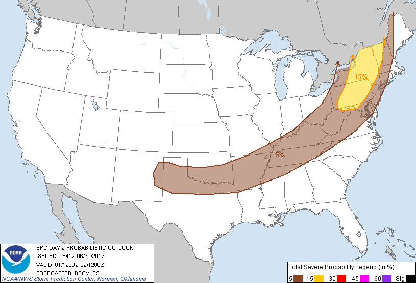
...THERE IS A SLIGHT RISK OF SEVERE THUNDERSTORMS ACROSS PARTS OF
THE NORTHEAST...
...THERE IS A MARGINAL RISK OF SEVERE THUNDERSTORMS OUTSIDE OF THE
SLIGHT RISK AREA FROM PARTS OF THE NORTHEAST WEST-SOUTHWESTWARD INTO
THE SOUTHERN PLAINS...
...SUMMARY...
Severe thunderstorms associated with damaging wind gusts and
isolated large hail will be possible across the Northeast Saturday
afternoon into early evening. Marginally severe storms will be
possible from the southern Plains east-northeastward into the
central Appalachians.
...Northeast...
An upper-level trough will move across the Great Lakes on Saturday
with southwest mid-level flow across the Northeast. At the surface,
a cold front will advance eastward across the lower Great Lakes and
into the Northeast by Saturday afternoon. Thunderstorms will
probably be ongoing along the front during the morning with a marked
increase in convective coverage taking place in the afternoon.
Warming surface temperatures ahead of the front should result in a
corridor of moderate instability by afternoon. As this occurs,
storms should become increasingly organized along the cold front.
Other storms should develop eastward along a warm front moving
through northern New York and New England. Multiple line segments
will be possible across the slight risk area during the afternoon
and early evening.
GFS forecast soundings along the instability axis in the Northeast
at 21Z on Saturday show moderate deep-layer shear profiles with
gradually veering winds with height and about 50 kt of
west-southwesterly flow at upper levels. This will support supercell
development with storms that can remain discrete or with the
stronger cells embedded in a line. Supercells will have potential to
produce isolated large hail. The stronger supercells may have an
isolated tornado threat especially along the warm front in northern
New York and Vermont. The greater threat may be damaging wind gusts
as a line of storms organizes across the Northeast. Damaging wind
gusts will be most likely with bowing structures.
...Southern Plains/Mid Mississippi Valley/Central Appalachians...
An upper-level trough will move eastward across the Mississippi
Valley on Saturday as a cold front advances southeastward across the
mid Mississippi Valley and Central Appalachians. Surface heating
ahead of the front along with dewpoints in the mid to upper 60s F
should result in pockets of moderate instability during the
afternoon. Thunderstorms that can develop along the front may have a
marginal wind-damage threat mainly in areas with moderate
instability and steep low-level lapse rates.
Farther west across the southern Plains, the front is expected to
stall in the Red River Valley where surface dewpoints should be in
the upper 60s and lower 70s F. The GFS and NAM solutions suggest
that a pocket of strong instability will be possible in the Red
River Valley Saturday afternoon. In spite of this, deep-layer shear
profiles should remain relatively weak. This should keep any severe
threat marginal across the Southern Plains with strong wind gusts
and hail the primary threats.
..Broyles.. 06/30/2017
CLICK TO GET WUUS02 PTSDY2 PRODUCT
NOTE: THE NEXT DAY 2 OUTLOOK IS SCHEDULED BY 1730Z