SPC AC 061707
Day 2 Convective Outlook
NWS Storm Prediction Center Norman OK
1207 PM CDT Thu Jul 06 2017
Valid 071200Z - 081200Z
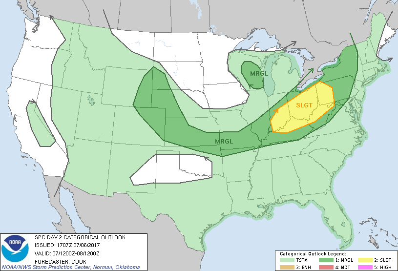
...THERE IS A SLIGHT RISK OF SEVERE THUNDERSTORMS ACROSS PORTIONS OF
THE OHIO VALLEY...
...THERE IS A MARGINAL RISK OF SEVERE THUNDERSTORMS FROM THE
CENTRAL/NORTHERN HIGH PLAINS SOUTHEASTWARD TO SOUTHERN MISSOURI AND
NORTHEASTWARD TO THE NORTHEAST...
...THERE IS A MARGINAL RISK OF SEVERE THUNDERSTORMS ACROSS PARTS OF
WISCONSIN...
...SUMMARY...
Strong to severe storms are expected to develop Friday afternoon
over the Ohio Valley and possibly into a portion of the Northeast
States. A few other strong to severe storms are possible from the
mid-Mississippi Valley westward to the central and northern High
Plains later Friday afternoon and evening.
...Synopsis...
A large-scale mid/upper trough will amplify across portions of the
eastern U.S., with shortwave troughs migrating the base of this
trough across the Great Lakes and Northeast. Farther west, a stout
mid/upper ridge will remain anchored over the Four Corners and
Intermountain West. At the surface, a cold front initially from
Lower Michigan to Iowa and Nebraska, will migrate southeastward as a
substantial surface ridge settles into the Northern Plains and upper
Mississippi Valley. This front will be the primary impetus for
scattered strong to severe storms across parts of the Northeast,
Ohio Valley, and central/northern High Plains especially from Friday
afternoon into Friday evening.
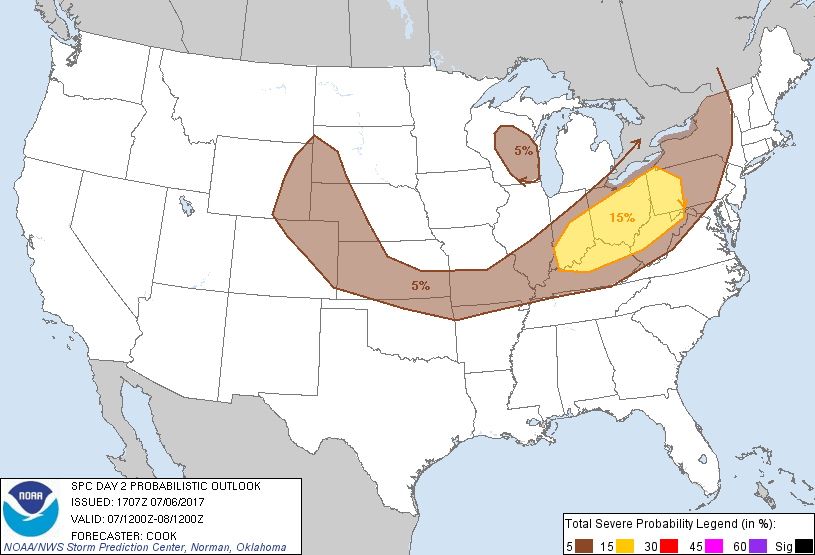
...Ohio Valley into the Northeast...
Over the course of the afternoon, models indicate that several
broken bands/linear convective segments will develop initially from
Indiana/Ohio northeast to the vicinity of Lakes Erie/Ontario -
perhaps as early as 18Z. Although low-level shear is fairly weak
across the region, deep shear will favor storm organization as a
corridor of enhanced mid-level flow (40-50 knots) overspreads the
region. Modest veering of profiles may support updraft rotation in
isolated updrafts, although broken linear segments should foster a
hail/damaging wind threat especially in portions of the Ohio Valley
where surface-based instability will be maximized (around 2000-3000
J/kg MUCAPE). Farther northeast, weaker buoyancy over New
York/Pennsylvania may result in a more isolated threat for damaging
wind gusts, and only 5%/marginal probabilities are retained in that
area for this forecast.
...Southeastern Kansas/northern Oklahoma into western Kentucky...
At least isolated convective activity will develop along a
southeastward-moving cold front across the region during peak
heating hours as model point forecast soundings indicate minimal
inhibition amidst moderate to strong instability (3000-4000 J/kg
MUCAPE). Deep shear profiles are somewhat weaker than farther
northeast as the region resides on the southern fringe of stronger
flow to the north. However, the presence of modest deep shear for
storm organization suggests at least an isolated potential for
damaging downburst winds and large hail given steep mid-level lapse
rates (and assuming at least isolated convective coverage).
5%/marginal severe probabilities extend into this region to address
the isolated severe threat.
...Portions of the Plains from southwestern South Dakota into
central Kansas...
The aforementioned cold front should extend from central Kansas
westward to northeastern Colorado by mid-afternoon, with
easterly/upslope surface wind fields across the High Plains.
Scattered strong to severe thunderstorms are expected to develop by
the afternoon (especially across the High Plains), with perhaps some
evolution into clusters/linear segments into the evening. The
presence of a northwest-to-southeast oriented axis of moderate
instability and 20-30 knot northwesterly surface flow suggests that
storms will tend to propagate southeastward toward central Kansas
into the evening hours. At least an isolated severe hail and wind
threat will exist with this activity, with a potential for an
upgrade to Slight risk in later outlooks once uncertainties
regarding convective coverage of storms can be resolved.
...Wisconsin...
A shortwave trough axis will approach the region during the
afternoon as surface temperatures rise into the 70s and low 80s F.
The region will also reside beneath the left exit region of a
mid-level jet max over Iowa and Illinois. Moderate instability and
the aforementioned sources of lift will foster scattered
thunderstorm development, with perhaps a few 1" hail stones and
near-severe wind gusts occurring in the strongest activity.
5%/marginal severe probabilities have been added to this outlook for
these reasons.
..Cook.. 07/06/2017
CLICK TO GET WUUS02 PTSDY2 PRODUCT
NOTE: THE NEXT DAY 2 OUTLOOK IS SCHEDULED BY 0600Z