New York, NY...Philadelphia, PA...Memphis, TN...Baltimore, MD...Washington, DC...
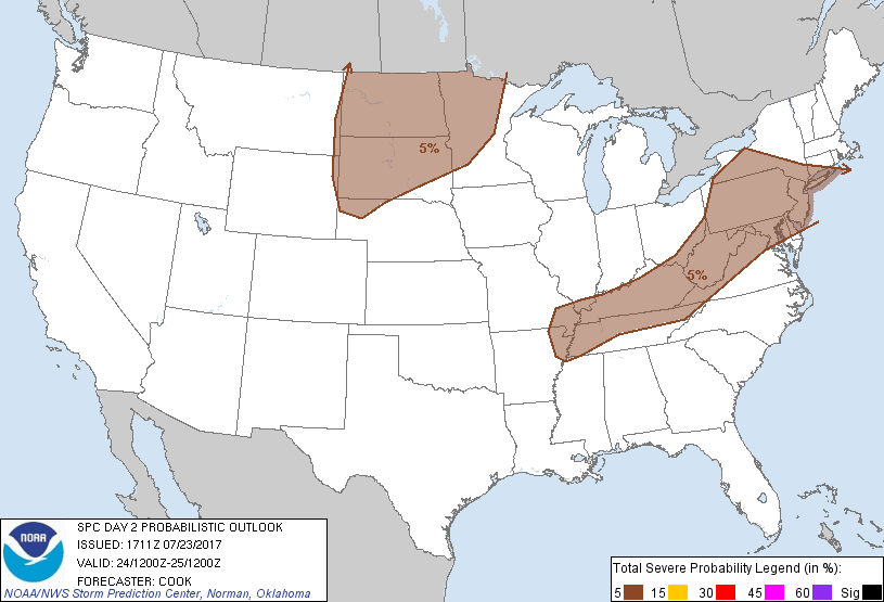
Probabilistic Graphic
Probability of severe weather within 25 miles of a point. Hatched Area: 10% or greater probability of significant severe within 25 miles of a point.
Day 2 Prob. Risk
Area (sq. mi.)
Area Pop.
Some Larger Population Centers in Risk Area
5 %
408,552
61,444,576
New York, NY...Philadelphia, PA...Memphis, TN...Baltimore, MD...Washington, DC...
   SPC AC 231711

   Day 2 Convective Outlook
   NWS Storm Prediction Center Norman OK
   1211 PM CDT Sun Jul 23 2017

   Valid 241200Z - 251200Z

   ...THERE IS A MARGINAL RISK OF SEVERE THUNDERSTORMS ACROSS PORTIONS
   OF THE NORTHERN PLAINS...

   ...THERE IS A MARGINAL RISK OF SEVERE THUNDERSTORMS ACROSS PORTIONS
   OF THE MID-SOUTH...OHIO VALLEY...APPALACHIANS...AND NORTHEAST...

   ...SUMMARY...
   Isolated strong/severe storms may occur over portions of the
   northern Plains vicinity, as well as across parts of the central
   Appalachians, Mid-Atlantic, and Mid-South regions.

   ...Synopsis...
   A broad mid/upper trough initially centered over the Great Lakes
   will gradually lift northeastward into southeastern Canada while
   weakening throughout the D2/Monday forecast period.  As this occurs,
   another vigorous upstream disturbance centered over Alberta will
   reach Manitoba overnight, while another compact and nearly
   stationary mid-level low remains across northwestern California.
   The Alberta disturbance will spread enhanced, cyclonically oriented
   flow across areas of the northern Rockies/Plains and may provide
   impetus for convective activity in the afternoon and overnight
   hours.  Farther south, a broad ridge will remain nearly stationary
   from the Four Corners eastward to the central/southern Plains.

   At the surface, a weak low pressure area over western New York will
   migrate slowly eastward throughout the day, and a trailing cold
   front will migrate southward across the Ohio Valley into Kentucky
   during the afternoon.  This front will become ill-defined with
   westward extent across Missouri.  Farther west, a lee trough will
   develop along the High Plains south of a substantial surface cyclone
   over Alberta.  Late in the period, a cold front will migrate
   southward across eastern Montana and eventually merge with the North
   Dakota portions of the trough.

   ...Much of the Dakotas into Minnesota...
   A complicated forecast scenario should result in at least an
   isolated threat for hail and damaging wind gusts from the afternoon
   onward across the Dakotas - and eventually overnight over Minnesota.
    The combination of convergence along the aforementioned lee trough
   across western North Dakota/South Dakota and strong surface heating
   should result in development of at least isolated high-based
   convection across the region after 21Z or so.  This development
   should occur to the west of deeper boundary-layer moisture and pose
   a threat for severe wind gusts and hail given steep (8 deg C/km)
   mid-level lapse rates and around 30-40 deg F surface dewpoint
   depressions.  A separate area of development may occur just ahead of
   a surface low/dryline over central South Dakota if heating/low-level
   convergence can overcome weak inhibition depicted in model point
   forecast soundings.  An isolated high-based supercell cannot be
   ruled out in this regime given backed low-level flow ahead of the
   low.  Any storms that develop in the afternoon may struggle to
   persist beyond sunset, however, as inhibition increases with the
   onset of nocturnal boundary layer cooling.  One exception to this
   may be in northern/central North Dakota, where mid-level forcing
   attendant to the Alberta trough may instigate deeper convection
   persisting into the evening and overnight hours.  This scenario may
   require an upgrade to 15%/Slight in later outlooks pending greater
   certainty of convective coverage.

   A second regime for elevated hail potential will exist farther east
   into central Minnesota and vicinity.  Here, convergence on the nose
   of a 50-kt 850mb jet stream centered in South Dakota, along with
   steep mid-level lapse rates, will foster at least isolated storms
   with hail overnight.  Again, a greater coverage of storms than
   currently anticipated may necessitate an upgrade to 15%/Slight in
   later outlooks.

   ...Portions of the Mid-South northeastward to the Appalachians and
   Northeast...
   A diurnally driven threat for isolated/sporadic damaging wind gusts
   will develop in the afternoon across the region - especially where
   sufficient insolation and destabilization can occur.  The area most
   likely for strong destabilization will exist in portions of
   Kentucky/Tennessee ahead of a southward-moving cold front, where
   mid-70s F dewpoints and surface temperatures reaching into the 90s F
   will foster around 3000-4000 J/kg of MUCAPE.  Deep shear is meager
   in this region, however, and will likely lead to loosely organized
   convective clusters in the afternoon hours.

   Farther north into New York/Pennsylvania, deep shear will favor
   better organization of any activity that can develop in the
   afternoon, although instability should be notably weaker (around
   1000-1500 J/kg MUCAPE).  Broad 5%/Marginal probabilities have been
   maintained for this update to address the isolated threat.

   ..Cook.. 07/23/2017

   CLICK TO GET WUUS02 PTSDY2 PRODUCT

   NOTE: THE NEXT DAY 2 OUTLOOK IS SCHEDULED BY 0600Z