SPC AC 260607
Day 2 Convective Outlook
NWS Storm Prediction Center Norman OK
0107 AM CDT Wed Jul 26 2017
Valid 271200Z - 281200Z
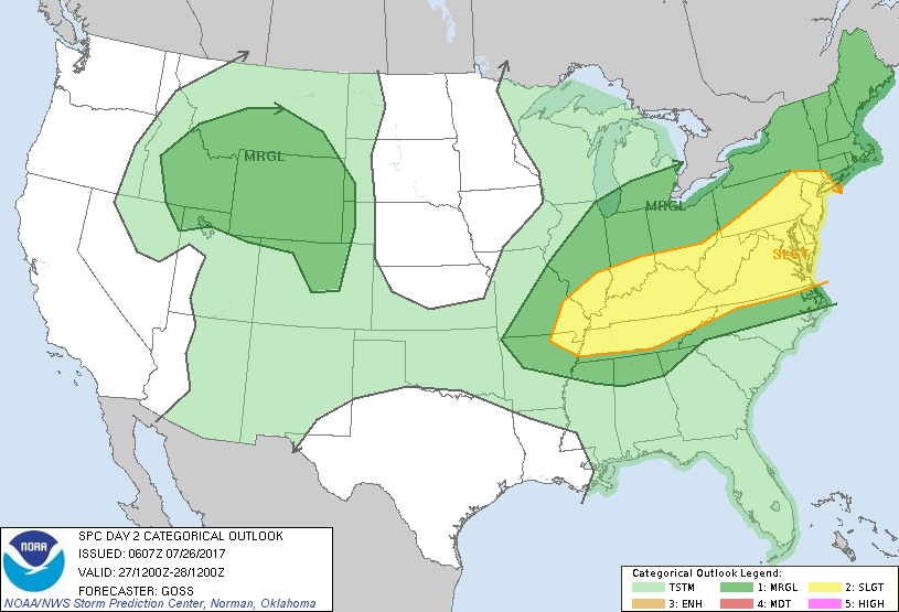
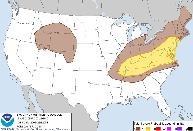
...THERE IS A SLIGHT RISK OF SEVERE THUNDERSTORMS FROM THE MID
MISSISSIPPI VALLEY EAST-NORTHEAST TO THE MID ATLANTIC REGION...
...THERE IS A MARGINAL RISK OF SEVERE THUNDERSTORMS SURROUNDING THE
SLIGHT RISK AREA...AND INCLUDING THE LOWER GREAT LAKES AND NEW
ENGLAND...
...THERE IS A MARGINAL RISK OF SEVERE THUNDERSTORMS ACROSS PORTIONS
OF THE INTERMOUNTAIN REGION AND VICINITY...
...SUMMARY...
Strong/locally severe storms are forecast to spread across the Ohio
and Tennessee Valleys, central Appalachians and into the mid
Atlantic region and vicinity Thursday afternoon and evening.
Isolated severe risk may also evolve across the northern
Intermountain region Thursday afternoon/evening.
...Synopsis...
As a weak short-wave trough advances northeast into the northern
Intermountain region on the northwest fringe of large-scale ridging,
amplification of troughing will occur over the eastern U.S. while a
short-wave trough digs southeast across the Great Lakes region.
At the surface, a weak cold front will advance across the northwest
states, while a second front advances southeast out of Canada and
into the northeast U.S., and southward across the Midwest/Ohio
Valley area. These boundaries will be associated with the two main
areas of stronger convection through the period.
...Mid MS/OH/TN Valleys east to the mid Atlantic region...
Models remain uncertain with respect to handling of lead upper
short-wave troughing forecast to cross the OH and TN valleys/central
Appalachians/mid Atlantic region during the day Thursday, ahead of
the main trough digging southeast across the Great Lakes.
Differences abound with respect to amount/intensity/location of
convection associated with this lead trough.
At this time, it appears that isolated storms will spread southeast
across the Great Lakes region, and across the St. Lawrence Valley
into the northeast U.S. during the afternoon. Modest CAPE and ample
shear will likely allow a few stronger storms/storm clusters to
evolve, resulting in local risk for primarily damaging winds.
Farther southeast into the slight risk area, models continue to
indicate that destabilization of the pre-frontal warm sector will
support areas of storm development -- aided by ascent associated
with the aforementioned lead upper trough. Some trend in the models
is evident to indicate that greatest convective coverage may now
occur west of the mountains over the OH/TN Valley area, where ample
shear for some storm organization -- and damaging wind risk -- would
reside. As such, westward expansion of the slight risk into this
region is being included. Otherwise, less certain, isolated severe
risk is still expected east of the mountains into parts of the mid
Atlantic area thus warranting continuation of slight risk at this
point. Risk may continue into the overnight hours, as the main
upper system continues to dig southeast.
...Northern Intermountain region to the central High Plains...
Modest, high-based afternoon CAPE development is expected across
parts of the Intermountain region Thursday, as a weak short-wave
advances anticyclonically northeast around the northwest portion of
the upper ridge. This will support development of isolated to
scattered storms -- across parts of the Intermountain region as well
as into a low-level upslope flow regime over the central High
Plains. With moderate mid-level flow overspreading parts of the
region in conjunction with the advancing upper system, a few
stronger storms will likely emerge from within the broader area of
showers and storms -- and will be capable of producing evaporatively
aided damaging winds. Risk should continue into the evening, before
storms begin to diurnally diminish in coverage/intensity.
..Goss.. 07/26/2017
CLICK TO GET WUUS02 PTSDY2 PRODUCT
NOTE: THE NEXT DAY 2 OUTLOOK IS SCHEDULED BY 1730Z