Garden City, KS...Hays, KS...Great Bend, KS...Lamar, CO...
MARGINAL
113,977
5,717,269
Denver, CO...Colorado Springs, CO...Wichita, KS...Aurora, CO...Lakewood, CO...
Probabilistic Graphic
Probability of severe weather within 25 miles of a point. Hatched Area: 10% or greater probability of significant severe within 25 miles of a point.
Day 2 Prob. Risk
Area (sq. mi.)
Area Pop.
Some Larger Population Centers in Risk Area
15 %
36,412
223,311
Garden City, KS...Hays, KS...Great Bend, KS...Lamar, CO...
5 %
114,089
5,703,257
Denver, CO...Colorado Springs, CO...Wichita, KS...Aurora, CO...Lakewood, CO...
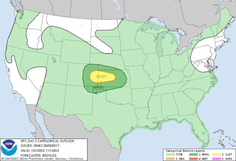
   SPC AC 090546

   Day 2 Convective Outlook
   NWS Storm Prediction Center Norman OK
   1246 AM CDT Wed Aug 09 2017

   Valid 101200Z - 111200Z

   ...THERE IS A SLIGHT RISK OF SEVERE THUNDERSTORMS ACROSS PARTS OF
   EASTERN COLORADO INTO CENTRAL KANSAS...

   ...THERE IS A MARGINAL RISK OF SEVERE THUNDERSTORMS OUTSIDE OF THE
   SLIGHT RISK AREA ACROSS PARTS OF THE CENTRAL AND SOUTHERN HIGH
   PLAINS...

   ...SUMMARY...
   Scattered thunderstorms will affect a large area of the United
   States on Thursday. A chance for isolated large hail and a few
   damaging wind gusts will be possible across parts of the central
   Plains Thursday afternoon and evening. Marginally severe
   thunderstorms could also affect parts of the southern High Plains as
   well.

   ...Central and Southern High Plains...
   An upper-level trough will move across the upper Mississippi Valley
   on Thursday with a secondary shortwave trough extending
   southwestward into the central Plains. At the surface, a cold front
   will advance southward into the central Plains. South of the front,
   surface dewpoints in the 60s F will likely result in a pocket of
   moderate instability by afternoon. Thunderstorms appear likely to
   develop along the front and move south-southeastward into the
   stronger instability during the late afternoon and early evening.
   Forecast soundings at 00Z/Friday from far eastern Colorado into
   central Kansas show 0-6 km shear in the 45 to 55 kt range suggesting
   supercells will be possible. The shear combined with steep mid-level
   lapse rates would support an isolated severe threat especially with
   rotating storms. MCS formation could also occur which would make
   isolated wind damage a possibility as well with the faster moving
   line segments. Have introduced a small slight risk from eastern
   Colorado into central Kansas along the axis where severe weather
   parameters are maximized.

   ..Broyles.. 08/09/2017

   CLICK TO GET WUUS02 PTSDY2 PRODUCT

   NOTE: THE NEXT DAY 2 OUTLOOK IS SCHEDULED BY 1730Z