SPC AC 120520
Day 2 Convective Outlook
NWS Storm Prediction Center Norman OK
1220 AM CDT Sat Aug 12 2017
Valid 131200Z - 141200Z
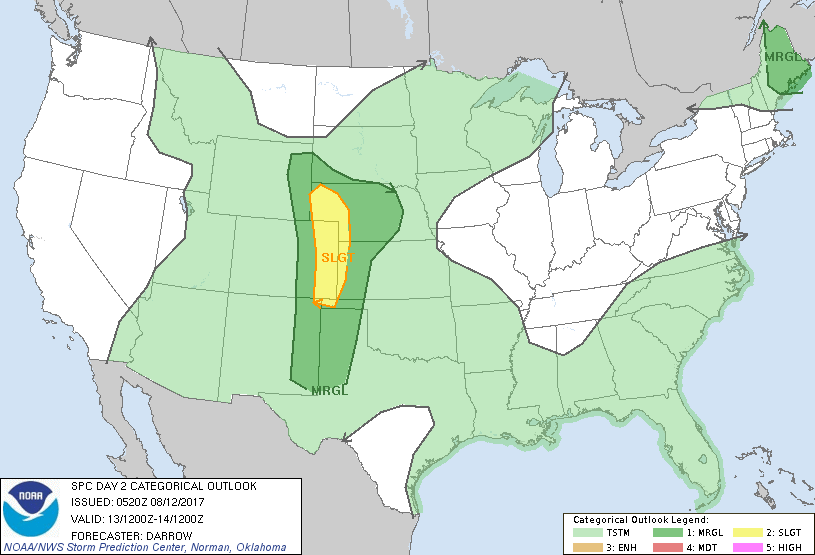
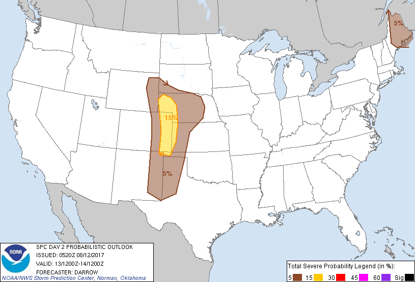
...THERE IS A SLIGHT RISK OF SEVERE THUNDERSTORMS ACROSS THE CENTRAL
AND SOUTHERN HIGH PLAINS...
...THERE IS A MARGINAL RISK OF SEVERE THUNDERSTORMS FROM SOUTHEAST
NM TO NORTHEAST WY...
...THERE IS A MARGINAL RISK OF SEVERE THUNDERSTORMS ACROSS PORTIONS
OF MAINE...
...SUMMARY...
Scattered thunderstorms, a few severe, are expected to develop
across the central and southern High Plains Sunday. A few strong
storms may also develop across portions of Maine.
...Central/Southern High Plains...
Northern High Plains short-wave trough will translate to a position
from the eastern Dakotas into the central Plains at daybreak Sunday.
In the wake of this feature modest northwesterly mid-level flow will
extend along a corridor from the High Plains into the base of the
trough over the mid MS Valley region. While short-wave troughing
will shift east of the SLGT risk region early, considerable amount
of convection is once again expected to develop over the higher
terrain of WY, south into NM. Some of this activity may drift into
an axis of considerable more buoyancy across the plains where shear
profiles are expected to support organized convection. Additionally,
strong surface heating near the lee trough, from southeast WY into
eastern NM, should result in thunderstorm development over the
plains after 22z. Veering/increasing wind profiles with height
suggest a few supercells are possible.
...Maine...
Seasonally strong mid-level height falls will spread across northern
New England during the day2 period ahead of a significant short-wave
trough that will advance to a position from southeast QC to MA by
18z. Latest short-range guidance suggests a narrow corridor of
strong pre-frontal heating will be noted from MA into northern ME.
While deep-layer flow veers ahead of the cold front this will allow
air mass to destabilize sufficiently for potential isolated
thunderstorm development along the front, possibly by 17z. Forecast
shear profiles would support organized updrafts and isolated
supercells may develop, especially across Downeast ME in closer
proximity to mid-level jet. Will maintain 5% severe across this
region due to the uncertainty of storm coverage; however, forecast
shear/buoyancy across Downeast ME supports the potential for
organized convection.
..Darrow.. 08/12/2017
CLICK TO GET WUUS02 PTSDY2 PRODUCT
NOTE: THE NEXT DAY 2 OUTLOOK IS SCHEDULED BY 1730Z