SPC AC 181658
Day 2 Convective Outlook
NWS Storm Prediction Center Norman OK
1158 AM CDT Fri Aug 18 2017
Valid 191200Z - 201200Z
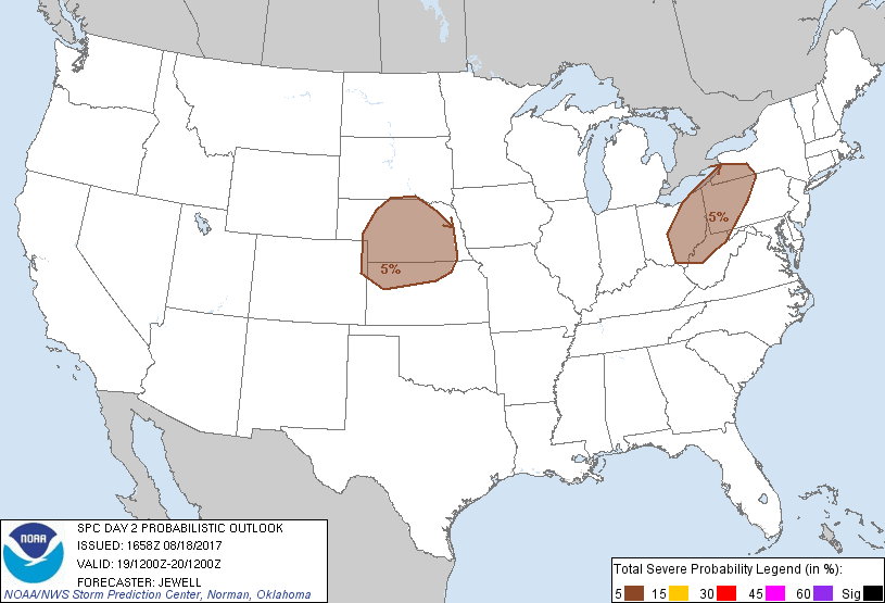
...THERE IS A MARGINAL RISK OF SEVERE THUNDERSTORMS ACROSS MUCH OF
NORTHERN KS INTO NE...
...THERE IS A MARGINAL RISK OF SEVERE THUNDERSTORMS FROM EASTERN OH
INTO WESTERN PA/NY/WV...
...SUMMARY...
Isolated severe storms are possible from Ohio into western
Pennsylvania and southwestern New York Saturday afternoon, and over
the central Plains late afternoon through evening.
...Synopsis...
A broad belt of southwesterly flow aloft will exist across the
northeastern part of the country, with upper trough shifting
eastward across the Ohio Valley during the day and into New England
overnight. At the surface, winds will be primarily westerly across
the region with the surface low well to the north over Quebec.
Dewpoints in the lower 60s will remain, which when combined with
cool air within the thermal trough aloft will result in sufficient
instability for a few strong storms.
To the west, shortwave ridging will exist across the Plains, in
advance of a strong upper trough over western Canada. A surface
trough will deepen during the day from the central Dakotas into
western NE and KS, with strong heating and an increasing low-level
jet aiding in storm development late in the day.
...OH into PA...
An area of rain and thunderstorms is forecast to be ongoing across
OH Saturday morning, in association with the upper trough axis. Some
heating may occur along and south of this potential storm track,
with some increase in intensity expected. Mean winds in the
low-levels will be relatively weak, but do increase aloft supporting
some good forward speed. Marginal instability and long hodographs
may support a few cells with marginal hail. Gusty winds are most
likely, but lack of any surface boundaries suggests any threat will
be tied to potential preexisting area of storms and associated
outflows.
...KS into NE...
Strong heating will lead to a deep layer of steep lapse rates and
will make the most of marginal boundary layer moisture to produce
1500-2000 J/kg MUCAPE. By late in the day, the cap will be eroded
and veering winds with height/warm advection profiles will aid in
the development of isolated clusters of storms, initiating in the
surface trough and developing east/southeastward during the evening
supported by an increasing low-level jet. Localized wind damage is
possible, with hail most likely early in the cycle.
..Jewell.. 08/18/2017
CLICK TO GET WUUS02 PTSDY2 PRODUCT
NOTE: THE NEXT DAY 2 OUTLOOK IS SCHEDULED BY 0600Z