Grand Island, NE...Kearney, NE...North Platte, NE...Sterling, CO...Fort Morgan, CO...
MARGINAL
88,373
1,794,217
Sioux Falls, SD...Fort Collins, CO...Greeley, CO...Longmont, CO...Loveland, CO...
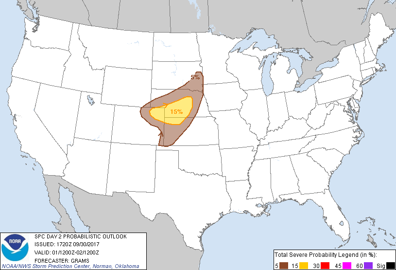
Probabilistic Graphic
Probability of severe weather within 25 miles of a point. Hatched Area: 10% or greater probability of significant severe within 25 miles of a point.
Day 2 Prob. Risk
Area (sq. mi.)
Area Pop.
Some Larger Population Centers in Risk Area
15 %
40,938
402,777
Grand Island, NE...Kearney, NE...North Platte, NE...Sterling, CO...Fort Morgan, CO...
5 %
88,373
1,794,217
Sioux Falls, SD...Fort Collins, CO...Greeley, CO...Longmont, CO...Loveland, CO...
SPC AC 301720
Day 2 Convective Outlook
NWS Storm Prediction Center Norman OK
1220 PM CDT Sat Sep 30 2017
Valid 011200Z - 021200Z
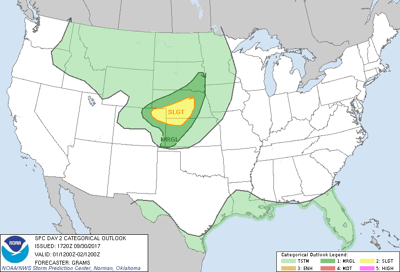
...THERE IS A SLIGHT RISK OF SEVERE THUNDERSTORMS CENTRAL GREAT
PLAINS...
...THERE IS A MARGINAL RISK OF SEVERE THUNDERSTORMS SOUTHEAST SD TO
THE CENTRAL HIGH PLAINS...
...SUMMARY...
Isolated to scattered severe storms are expected across parts of the
central Great Plains Sunday afternoon and evening.
...Synopsis...
A longwave trough will remain anchored over the West with an
embedded shortwave impulse amplifying across the northern High
Plains. This will coincide with strengthening mid-level
west-southwesterlies across the CO Rockies and into parts of SD to
KS, Sunday evening/night. Primary surface cyclone over ND should
gradually deepen as it shifts into southern Saskatchewan. A cold
front will arc from this cyclone to a low in the lee of the CO
Rockies.
...Central Great Plains...
Have expanded Marginal and Slight risks with an increasingly
probable expectation for at least a few severe storms, including
potential for a long-track supercell.
A relatively confined plume of modest boundary layer moisture
characterized by middle 50s to lower 60s should advect north from
southeast SD to central and southern High Plains. From the central
High Plains to the east-northeast, an elevated mixed layer will
overspread this moisture return, yielding sufficient inhibition
until afternoon amid steep mid-level lapse rates. Weak mid-level
height falls/DCVA should aid in storm initiation first off the Front
Range by mid afternoon. The aforementioned strengthening flow aloft
along with a veering wind profile with height will be favorable for
supercell formation. Most CAMs suggest a long-track supercell may
evolve east across northeast CO and southwest NE. Large hail will
likely be the primary hazard, but the tornado and wind threat may
increase towards the CO/NE/KS border area near 00Z where
boundary-layer moisture should be relatively richer.
Additional storms may form farther northeast along the strengthening
frontal zone during the evening, as well as to the south near the
dryline. Dryline storm initiation is more uncertain with southern
extent given warmer mid-level temperatures/minimal height change.
Cooler boundary-layer temperatures to the north/east from
central/eastern NE to southeast SD should spatially confine and tend
to limit the hazard to mainly severe hail.
..Grams.. 09/30/2017
CLICK TO GET WUUS02 PTSDY2 PRODUCT
NOTE: THE NEXT DAY 2 OUTLOOK IS SCHEDULED BY 0600Z