Minneapolis, MN...St. Paul, MN...Sioux Falls, SD...Duluth, MN...Sioux City, IA...
Probabilistic Graphic
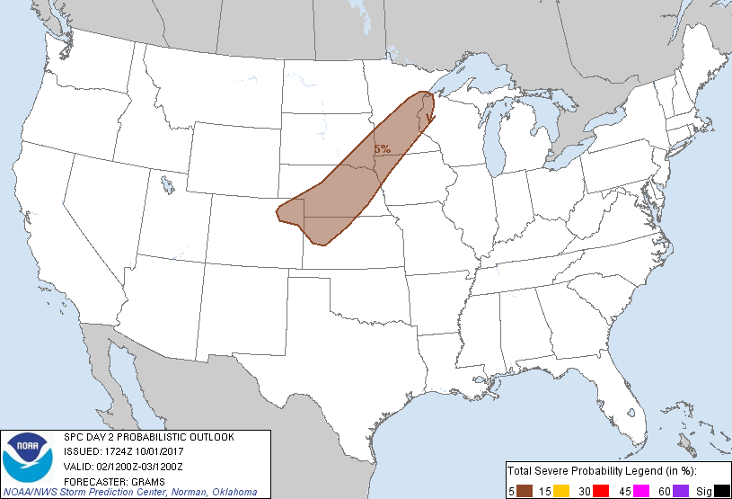
Probability of severe weather within 25 miles of a point. Hatched Area: 10% or greater probability of significant severe within 25 miles of a point.
Day 2 Prob. Risk
Area (sq. mi.)
Area Pop.
Some Larger Population Centers in Risk Area
5 %
128,204
5,893,982
Minneapolis, MN...St. Paul, MN...Sioux Falls, SD...Duluth, MN...Sioux City, IA...
SPC AC 011724
Day 2 Convective Outlook
NWS Storm Prediction Center Norman OK
1224 PM CDT Sun Oct 01 2017
Valid 021200Z - 031200Z
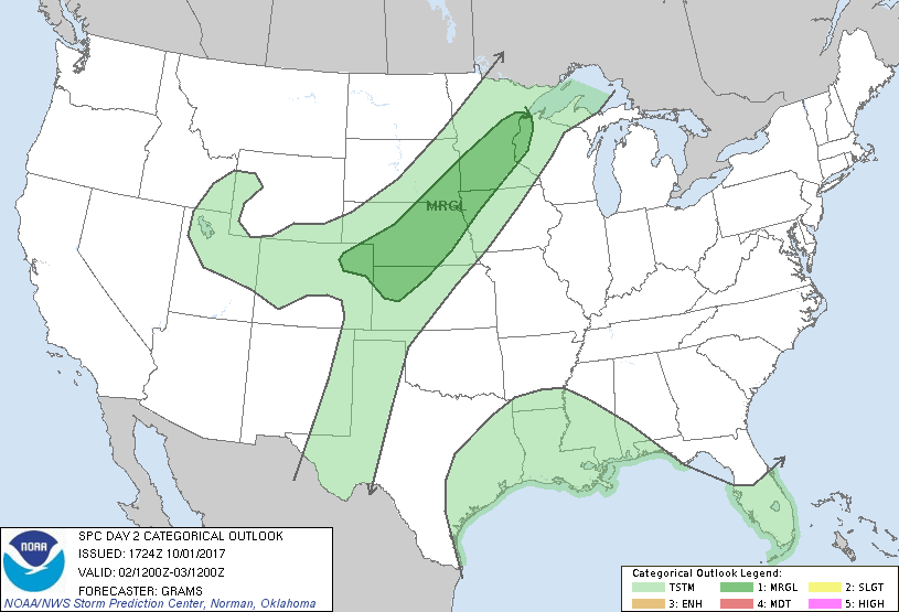
...THERE IS A MARGINAL RISK OF SEVERE THUNDERSTORMS UPPER MS VALLEY
TO CENTRAL HIGH PLAINS...
...SUMMARY...
Isolated severe storms are possible from the central High Plains to
the Upper Mississippi Valley late afternoon and evening on Monday.
...Synopsis...
A highly amplified upper pattern will persist with a longwave trough
in the West and ridge across the East. Two primary shortwave
impulses are expected to evolve, one along the northern Great Plains
international border and the other from the Great Basin to central
High Plains. At the surface, a quasi-stationary front modulated by
convective outflow on D1 should oscillate north and then again south
over the central Great Plains and Upper MS Valley.
...Central High Plains to Upper MS Valley...
Primary change is to shift the Marginal risk area to the southwest
and expand west over parts of the central High Plains. Considered a
Slight risk over parts of NE, but low confidence in the degree of
surface-based storm development yields deferral on an upgrade to
later outlooks.
Fast mid-level southwesterlies will remain prevalent along and west
of the quasi-stationary front with near-neutral to weak mid-level
height rises expected over the frontal zone through much of the
period. However, low-level warm advection/isentropic ascent across
the boundary will strengthen Monday evening as a southerly low-level
jet intensifies in response to the ejecting Great Basin/Rockies
shortwave trough. This should result in increasingly widespread
convection on the cool side of the front within an anafrontal
regime. Appreciable MUCAPE will likely be confined near the front
with increasingly scant amounts to the north/west. However, amid
steep mid-level lapse rates within a remnant elevated mixed layer
and very strong speed shear, instability should remain sufficient
for a risk of severe hail. Surface-based storm development appears
unlikely, but is most possible along the front in NE where the
CAPE/shear environment would conditionally favor a risk for all
hazards.
..Grams.. 10/01/2017
CLICK TO GET WUUS02 PTSDY2 PRODUCT
NOTE: THE NEXT DAY 2 OUTLOOK IS SCHEDULED BY 0600Z