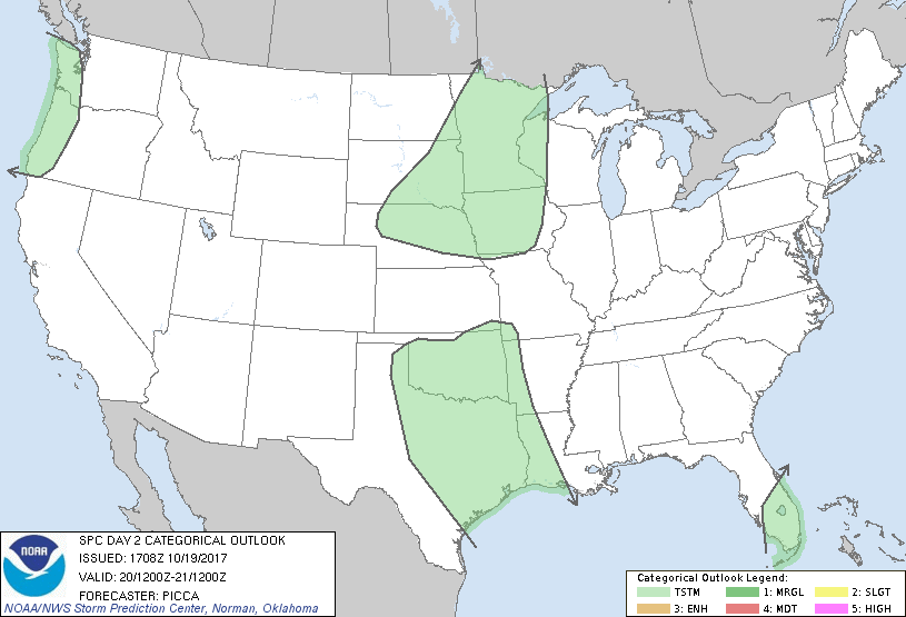
   SPC AC 191708

   Day 2 Convective Outlook
   NWS Storm Prediction Center Norman OK
   1208 PM CDT Thu Oct 19 2017

   Valid 201200Z - 211200Z

   ...NO SEVERE THUNDERSTORM AREAS FORECAST...

   ...SUMMARY...
   A few thunderstorms will be possible across the southern Plains,
   Florida Peninsula, and Pacific Northwest Friday. Isolated storms
   will also be possible Friday night across the mid Missouri and upper
   Mississippi Valleys.

   ...Discussion...
   As a series of strong upper jets move ashore the West Coast over the
   next 24 hours, 500mb heights will gradually fall over much of the
   western half of the US on Friday. Related to this evolution, several
   weak mid/upper perturbations will lift northeast from the southern
   Plains towards the upper Mississippi Valley through Friday and into
   the overnight hours. The associated low-level response will be
   characterized by a gradual northward advance of greater moisture,
   with a narrow corridor of lower/mid 60s surface dew points extending
   to the central Plains by Friday evening. Within this warm/moist
   advection regime, sufficient instability should be present for a few
   thunderstorms across Texas and Oklahoma, with the greatest
   likelihood closer to the Texas coast during the day. While effective
   shear and mid-level lapse rates could support a stronger storm or
   two across parts of western Oklahoma and adjacent portions of Texas,
   the nebulous nature of forcing for ascent, in addition to the
   presence of inhibition in the 850-700mb layer, will likely keep
   thunderstorm coverage too limited for the introduction of severe
   probabilities at this time.

   Farther north, within a broad regime of enhanced 850mb
   southwesterlies and related warm advection, isolated thunderstorms
   will be possible from the mid Missouri Valley northeastward to
   Minnesota Friday night. Although mid-level lapse rates should
   steepen some overnight, limited elevated buoyancy will likely keep
   storms isolated and below severe limits.

   ..Picca.. 10/19/2017

   CLICK TO GET WUUS02 PTSDY2 PRODUCT

   NOTE: THE NEXT DAY 2 OUTLOOK IS SCHEDULED BY 0600Z
|

