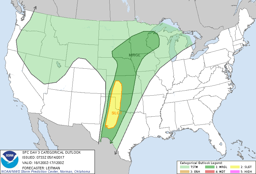
San Angelo, TX...Dodge City, KS...Big Spring, TX...Altus, OK...Hays, KS...
MARGINAL
266,439
12,335,545
Oklahoma City, OK...Omaha, NE...Minneapolis, MN...Wichita, KS...St. Paul, MN...
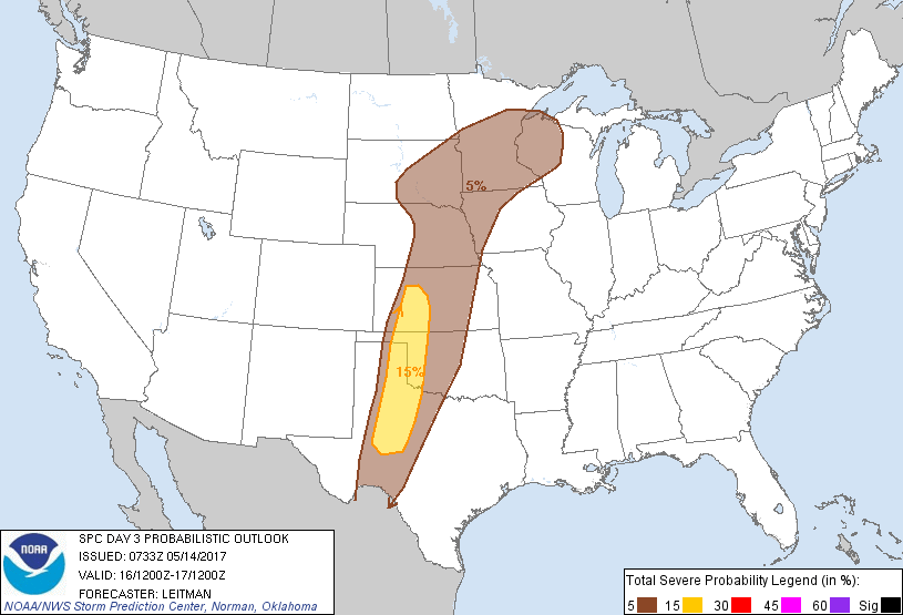
Probabilistic Graphic
Probability of severe weather within 25 miles of a point. Hatched Area: 10% or greater probability of significant severe within 25 miles of a point.
Day 3 Prob. Risk
Area (sq. mi.)
Area Pop.
Some Larger Population Centers in Risk Area
15 %
59,918
660,342
San Angelo, TX...Dodge City, KS...Big Spring, TX...Altus, OK...Hays, KS...
5 %
267,272
12,358,819
Oklahoma City, OK...Omaha, NE...Minneapolis, MN...Wichita, KS...St. Paul, MN...
   SPC AC 140733

   Day 3 Convective Outlook
   NWS Storm Prediction Center Norman OK
   0233 AM CDT Sun May 14 2017

   Valid 161200Z - 171200Z

   ...THERE IS A SLIGHT RISK OF SEVERE THUNDERSTORMS ACROSS PORTIONS OF
   THE SOUTHERN AND CENTRAL PLAINS...

   ...THERE IS A MARGINAL RISK OF SEVERE THUNDERSTORMS FROM WESTERN TX
   INTO THE UPPER MIDWEST...

   ...SUMMARY...
   Severe storms are expected across parts of the central and southern
   Plains on Tuesday. Large hail and damaging winds will be the main
   threats with these storms. Additional strong storms are possible
   from parts of the central Plains to the Upper Midwest.

   ...Synopsis...
   The southwestern trough will shift east to the central/southern High
   Plains by 12z Wed. This will bring a band of strong southwesterly
   deep-layer flow and forcing for ascent into the Plains. Moisture
   will continue to advect northward on strong low-level southerly flow
   and rich boundary-layer dewpoints are expected ahead of a dryline
   from central TX northward through OK/KS. This dryline will serve as
   a focus for severe thunderstorm development during the late
   afternoon and evening hours.

   Further north across the mid-MO Valley and Upper Midwest, strong
   warm advection will continue to increase boundary-layer moisture
   ahead of a surface low and southeastward advancing cold front.
   Additional strong, to potentially severe, storms are expected during
   the evening and overnight hours in the vicinity of these surface
   features as forcing for ascent increases.

   ...Southern/Central Plains...

   Some uncertainty exists as to the extent of the slight risk area.
   Deterministic guidance has a relatively cool boundary layer progged
   which seems questionable, especially in the vicinity of the sharp
   dryline. Further east of the dryline into central TX/OK/KS strong
   capping will be in place and some cloudiness is possible given
   strong warm advection regime. This should suppress convection here
   initially. Stronger heating in the vicinity of the dryline should
   result in at least isolated supercells from parts of western KS into
   the TX Panhandle/South Plains vicinity. These storms may be a bit
   high based, depending on degree of mixing and quality of low-level
   moisture, so large hail and damaging winds appear to be the main
   concern at this time. However, forecast low-level flow could support
   a tornado threat if richer moisture can advect further west near the
   dryline. Overnight, elevated convection is expected to move east
   into central KS/OK and could pose a hail threat.

   ...Mid-MO Valley/Upper Midwest Vicinity...

   Strong capping will again lead to uncertainty in any convection
   developing in the warm sector during the day, especially given that
   any stronger forcing does not arrive across the area until 00z or
   later. Additionally, a great deal of convection is expected Monday
   night and how the airmass responds and recovers will also influence
   diurnal severe potential. By evening, forcing increases and a
   southwesterly low-level jet will nose into the region as the surface
   low progresses eastward. Some surface-based threat could briefly
   develop along the cold front across parts of southeast SD/northeast
   NE into southern MN. More likely, elevated convection will accompany
   frontal passage overnight and hail will be the main concern.  Given
   aforementioned uncertainty, will only introduce marginal severe
   probs at this time.

   ..Leitman.. 05/14/2017

   CLICK TO GET WUUS03 PTSDY3 PRODUCT

   NOTE: THE NEXT DAY 3 OUTLOOK IS SCHEDULED BY 0730Z