Fort Worth, TX...Oklahoma City, OK...Tulsa, OK...Wichita, KS...Abilene, TX...
MARGINAL
133,646
14,574,801
San Antonio, TX...Dallas, TX...Austin, TX...Kansas City, MO...Arlington, TX...
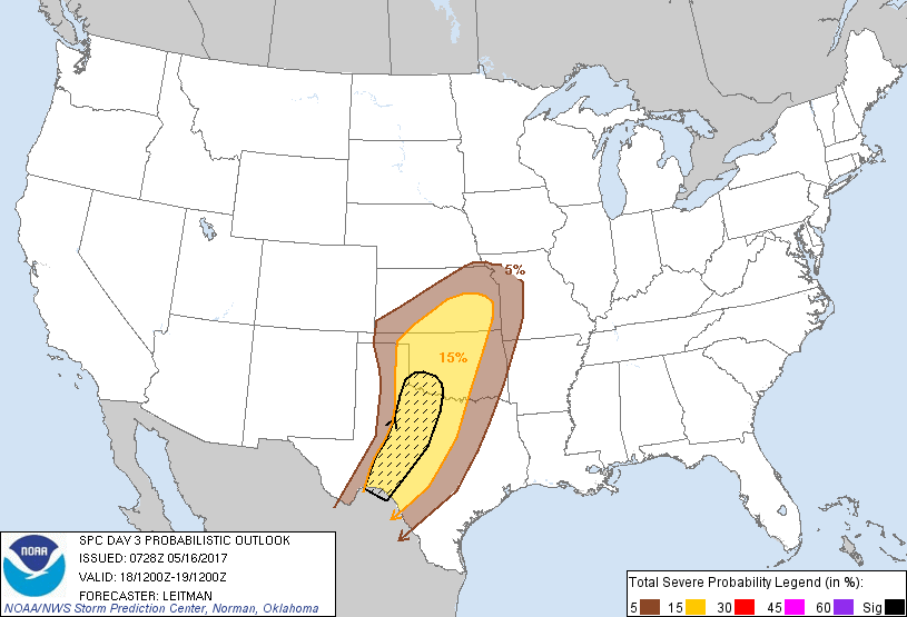
Probabilistic Graphic
Probability of severe weather within 25 miles of a point. Hatched Area: 10% or greater probability of significant severe within 25 miles of a point.
Day 3 Prob. Risk
Area (sq. mi.)
Area Pop.
Some Larger Population Centers in Risk Area
SIG SEVERE
48,031
798,529
Abilene, TX...Wichita Falls, TX...Lawton, OK...San Angelo, TX...Altus, OK...
15 %
149,485
7,145,072
Fort Worth, TX...Oklahoma City, OK...Tulsa, OK...Wichita, KS...Abilene, TX...
5 %
135,281
14,488,721
San Antonio, TX...Dallas, TX...Austin, TX...Kansas City, MO...Arlington, TX...
SPC AC 160728
Day 3 Convective Outlook
NWS Storm Prediction Center Norman OK
0228 AM CDT Tue May 16 2017
Valid 181200Z - 191200Z
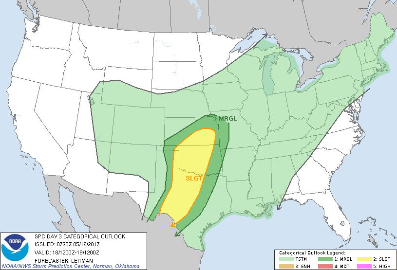
...THERE IS A SLIGHT RISK OF SEVERE THUNDERSTORMS FROM SOUTHEAST KS
INTO THE SOUTHERN PLAINS...
...THERE IS A MARGINAL RISK OF SEVERE THUNDERSTORMS SURROUNDING THE
SLIGHT RISK ACROSS PARTS OF THE CENTRAL AND SOUTHERN PLAINS...
...SUMMARY...
Severe thunderstorms are expected across parts of southeast Kansas
into the southern Plains Thursday afternoon into the overnight
hours. All severe hazards will be possible, including very large
hail, damaging winds and a few tornadoes.
...Synopsis...
The western upper low will shift east/southeast toward the
southern/central Rockies on Thursday. Strong deep-layer
southwesterly flow will persist across the southern and central
Plains ahead of the low and forcing for ascent will increase after
18z. At the surface, a lee cyclone will deepen in the vicinity of
eastern NM or the TX Panhandle. A dryline will retreat westward
during the morning, extending southward from the eastern TX
Panhandle into western TX by late afternoon, and rich low-level
moisture is expected ahead of this feature. Further north, a cold
front will be draped across KS to the Great Lakes vicinity. Severe
thunderstorms are expected to develop in the vicinity of these
surface boundaries by late afternoon.
...Central/Southern Plains...
There is some uncertainty in the location and evolution of surface
features, with the operational NAM appearing to be a bit of an
outlier. It is important to note this however, because it brings
the cold front surging southeast across the Plains much faster than
the GFS/ECMWF. This in turn would impact the northern and western
extent of severe probs. Have largely discounted the NAM solution for
now, given the outlier status compared to other guidance, but model
trends will need to be monitored closely in the coming day or two.
Otherwise, expect isolated to scattered thunderstorms to develop
along the sharp dryline by late afternoon as strong heating of a
moisture-rich boundary layer leads to strong instability. Impressive
midlevel lapse rates near 8-8.5 deg C/km and supercell-favoring
kinematic profiles will lead to a large, potentially significant,
hail threat. Additionally, strong winds and a few tornadoes will be
possible. The wind threat may increase during the overnight hours as
the cold front surges southeast and upscale growth becomes more
likely with eastward extent.
..Leitman.. 05/16/2017
CLICK TO GET WUUS03 PTSDY3 PRODUCT
NOTE: THE NEXT DAY 3 OUTLOOK IS SCHEDULED BY 0730Z