SPC AC 050726
Day 3 Convective Outlook
NWS Storm Prediction Center Norman OK
0226 AM CDT Wed Jul 05 2017
Valid 071200Z - 081200Z
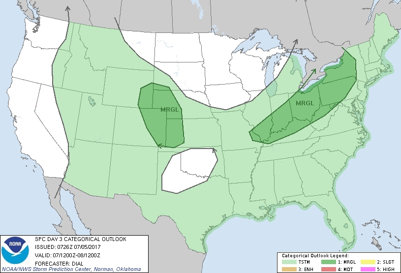
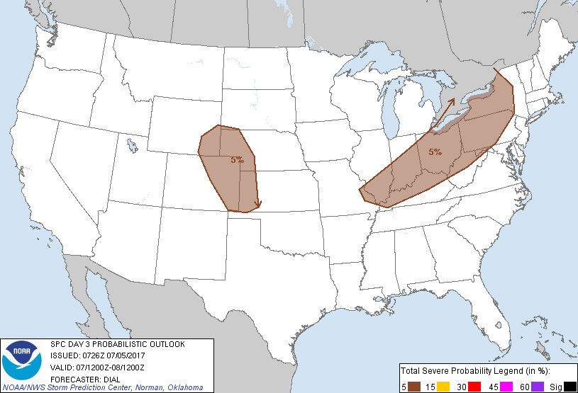
...THERE IS A MARGINAL RISK OF SEVERE THUNDERSTORMS FROM THE OHIO
VALLEY INTO A PORTION OF THE NORTHEAST STATES...
...THERE IS A MARGINAL RISK OF SEVERE THUNDERSTORMS OVER A PORTION
OF THE CENTRAL HIGH PLAINS...
...SUMMARY...
A few strong to severe storms are possible from the Ohio Valley into
a portion of the Northeast States Friday. Other strong storms are
possible over the central High Plains.
...Synopsis...
Synoptic pattern will change little on Friday with upper trough over
the eastern U.S. expected to undergo further amplification, while a
ridge persists over the western states. At the surface a cold front
will continue southeast through the Northeast States and OH Valley
in association with the amplifying trough. The western extension of
this boundary will stall across OK/KS.
...Ohio Valley area...
A moist pre-frontal warm sector with dewpoints in the upper 60s to
around 70F will reside across the OH Valley into a portion of the
Northeast States. Destabilization of the boundary layer will result
in moderate instability in the presence of modest mid-level lapse
rates. At least a modest increase in deep-layer winds is expected
with 30-40 kt unidirectional westerly between 2-6 km. A significant
upper speed max is forecast to move southeast into the Great Lakes
and Ohio Valley region, but this feature will remain post frontal.
Nevertheless...storms should redevelop within the weakly capped warm
sector and along the southeast advancing cold front during the
afternoon. Vertical shear from 25-35 kt will support primarily
multicells with storms evolving into clusters and line segments. A
few strong to damaging wind gusts will be possible through early
evening. Trends will continue to be monitored for a possible slight
risk in later updates.
...Central High Plains area...
As surface high shifts east, winds will return to southeasterly in
post frontal zone over the central High Plains where dewpoints in
the 40s to 50s F will advect westward beneath steep mid-level lapse
rates. This will contribute to a corridor of modest /500-1000 J/kg/
MLCAPE over the High Plains Friday afternoon. Isolated to widely
scattered storms should develop over the higher terrain and spread
southeast into the High Plains where they will pose some risk for
mainly isolated downburst winds through early evening.
..Dial.. 07/05/2017
CLICK TO GET WUUS03 PTSDY3 PRODUCT
NOTE: THE NEXT DAY 3 OUTLOOK IS SCHEDULED BY 0730Z