SPC AC 140730
Day 3 Convective Outlook
NWS Storm Prediction Center Norman OK
0230 AM CDT Fri Jul 14 2017
Valid 161200Z - 171200Z
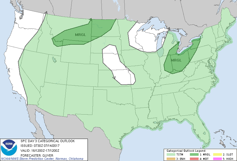
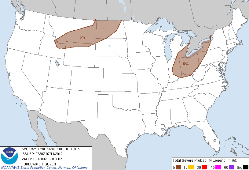
...THERE IS A MARGINAL RISK OF SEVERE THUNDERSTORMS ACROSS PARTS OF
THE OHIO VALLEY/GREAT LAKES...
...THERE IS A MARGINAL RISK OF SEVERE THUNDERSTORMS ACROSS THE
NORTHERN ROCKIES AND NORTHERN PLAINS...
...SUMMARY...
Isolated strong to severe thunderstorms may occur across parts of
the Ohio Valley and Great Lakes region in addition to the northern
Rockies and northern Plains.
...Ohio Valley/Great Lakes...
An upper low is likely to continue southeastward across the region
on Sunday, with a cold front also progressing southeastward. The
strongest diurnal destabilization is currently expected from parts
of OH/IN westward into IL, although overall forcing/mass convergence
is expected to be weaker along the front with westward extent.
Uncertainties also exist regarding the extensiveness and impacts of
prior-day convection upstream Saturday afternoon/night. Regardless,
given a moist pre-frontal environment and the possibility of
moderate quantities of buoyancy and effective shear, at least some
potential will exist across the region for damaging winds and
possibly some hail.
...Northern Rockies to Dakotas...
An upper trough likely to be over the Canadian Rockies early Sunday
will continue eastward toward the Canadian prairies, with height
falls overspreading MT/northern WY into the Dakotas through Sunday
afternoon and night. Only modest moisture will precede an
east/southeastward-spreading surface low and front, although
post-frontal moistening should occur late in the day across southern
MT and northern WY. While deep-layer shear will also be relatively
weak (25-30 kt or less), steep lapse rates related to a relatively
hot/well-mixed boundary layer could support some potential for
severe-caliber downdrafts with any thunderstorms that develop over
the higher terrain and mountains of ID/southern MT/northern WY
and/or along and just behind the advancing front/triple point
extending into the Dakotas.
...Southeast states...
A few strong to locally severe pulse-type thunderstorms could occur
Sunday afternoon into early evening within a moist environment along
and south of a stalled and weakening front. While a few severe
storms could occur, the specific locations and likelihood of such is
questionable given overall weak/subtle forcing mechanisms and
uncertain impacts of prior-day convection.
...AZ/Desert Southwest...
A few strong storms could occur Sunday afternoon and evening as a
moist monsoon-related air mass persists across the region. However,
with expectations of modestly weakening ridge into Sunday, steering
winds off the high terrain should be weaker than prior days.
..Guyer.. 07/14/2017
CLICK TO GET WUUS03 PTSDY3 PRODUCT
NOTE: THE NEXT DAY 3 OUTLOOK IS SCHEDULED BY 0730Z