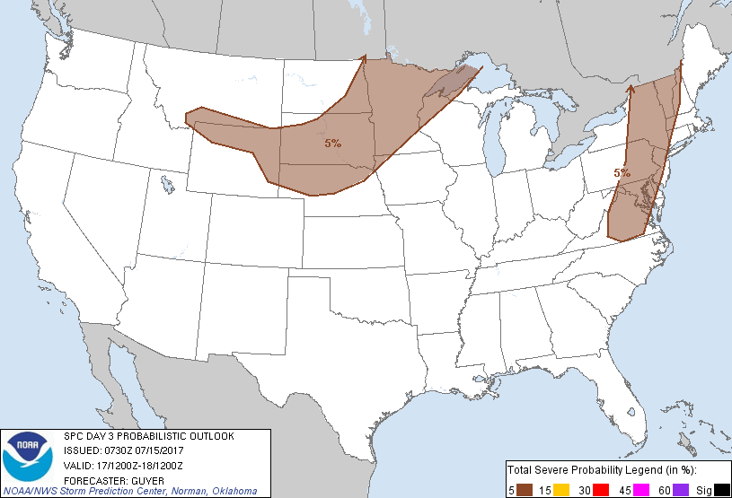
New York, NY...Philadelphia, PA...Baltimore, MD...Washington, DC...Minneapolis, MN...
Probabilistic Graphic
Probability of severe weather within 25 miles of a point. Hatched Area: 10% or greater probability of significant severe within 25 miles of a point.
Day 3 Prob. Risk
Area (sq. mi.)
Area Pop.
Some Larger Population Centers in Risk Area
5 %
380,967
43,347,255
New York, NY...Philadelphia, PA...Baltimore, MD...Washington, DC...Minneapolis, MN...
SPC AC 150730
Day 3 Convective Outlook
NWS Storm Prediction Center Norman OK
0230 AM CDT Sat Jul 15 2017
Valid 171200Z - 181200Z
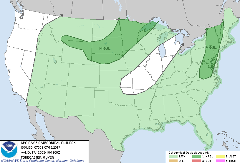
...THERE IS A MARGINAL RISK OF SEVERE THUNDERSTORMS ACROSS THE UPPER
MIDWEST AND NORTH-CENTRAL HIGH PLAINS...
...THERE IS A MARGINAL RISK OF SEVERE THUNDERSTORMS ACROSS THE
NORTHEAST/MID-ATLANTIC STATES...
...SUMMARY...
Strong to severe thunderstorms will be possible Monday across parts
of the Northeast and mid-Atlantic states, as well as the Upper
Midwest and north-central High Plains.
...Upper Midwest/North-Central High Plains...
An eastward-progressive upper-level trough will continue to cross
the Canadian prairies on Monday, with at least weak height falls and
some mid-level cooling grazing the far northern tier of the CONUS
from ND to northern MN and the Lake Superior vicinity. There should
be at least some potential for severe thunderstorms across the
region Monday, perhaps especially along an east-southeastward moving
front where moderate destabilization may occur (especially across
parts of MN). Other strong to severe thunderstorms could occur
Monday afternoon and evening with a more modestly moist/unstable
terrain-aided regime across southern MT/parts of WY into the
north-central High Plains. Portions of the Upper Midwest,
particularly northern and central MN, will be reevaluated in
subsequent outlooks for a possible categorical Slight Risk upgrade.
...Northeast/mid-Atlantic States...
An upper low (and its related mid-level cool pocket) will likely
continue eastward over the Northeast states on Monday. While
early-day cloud cover and precipitation could exist across parts of
the region, at least weak to moderate destabilization should occur
into downstream areas along and especially east of the Appalachians
vicinity. At least some strong to severe thunderstorms would appear
to be a possibility mainly Monday afternoon into early evening, with
damaging winds as the most common severe risk.
..Guyer.. 07/15/2017
CLICK TO GET WUUS03 PTSDY3 PRODUCT
NOTE: THE NEXT DAY 3 OUTLOOK IS SCHEDULED BY 0730Z