   ZCZC SPCPWOSPC ALL
   WOUS40 KWNS 270619
   ARZ000-ILZ000-INZ000-KSZ000-KYZ000-MOZ000-OKZ000-TNZ000-271800-

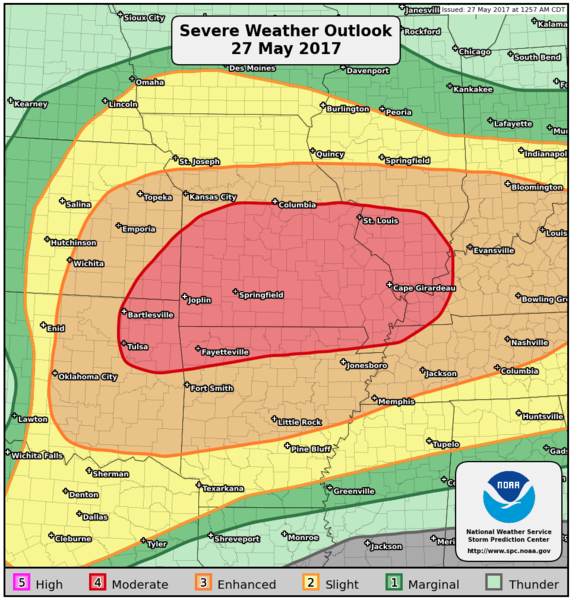
   PUBLIC SEVERE WEATHER OUTLOOK
   NWS STORM PREDICTION CENTER NORMAN OK
   0119 AM CDT SAT MAY 27 2017

   ...Severe thunderstorms expected over parts of the Ozarks to lower
   Ohio Valley later today and tonight...

   * LOCATIONS...
     Central and southern Missouri
     Southern Illinois
     Northern Arkansas
     Western Kentucky
     Eastern Oklahoma
     Northwestern Tennessee
     Eastern Kansas
     Extreme southwestern Indiana

   * HAZARDS...
     Widespread damaging winds, some hurricane force
     A few intense tornadoes
     Widespread large hail, some baseball size

   * SUMMARY...
     Widespread severe wind gusts are forecast from the Ozarks
     eastward to the lower Ohio Valley today. Additionally, very
     large to giant hail and tornadoes will be possible from the Red
     River Valley northeastward to the Ozark Plateau. Damaging winds,
     large hail, and a couple tornadoes will also be possible across
     the Tennessee Valley, middle Ohio Valley, and portions of the
     Mid-Atlantic.

   Preparedness actions...

   Review your severe weather safety procedures for the possibility
   of dangerous weather today. Stay tuned to NOAA Weather Radio,
   weather.gov, or other media for watches and warnings. A watch
   means that conditions are favorable for severe thunderstorms
   over the next several hours. If a severe thunderstorm warning is
   issued for your area, move to a place of safety, ideally in an
   interior room on the lowest floor of a sturdy building.

   &&

   ..Edwards.. 05/27/2017

   $$
|
