SPC AC 110549
Day 1 Convective Outlook
NWS Storm Prediction Center Norman OK
1149 PM CST Wed Jan 10 2018
Valid 111200Z - 121200Z
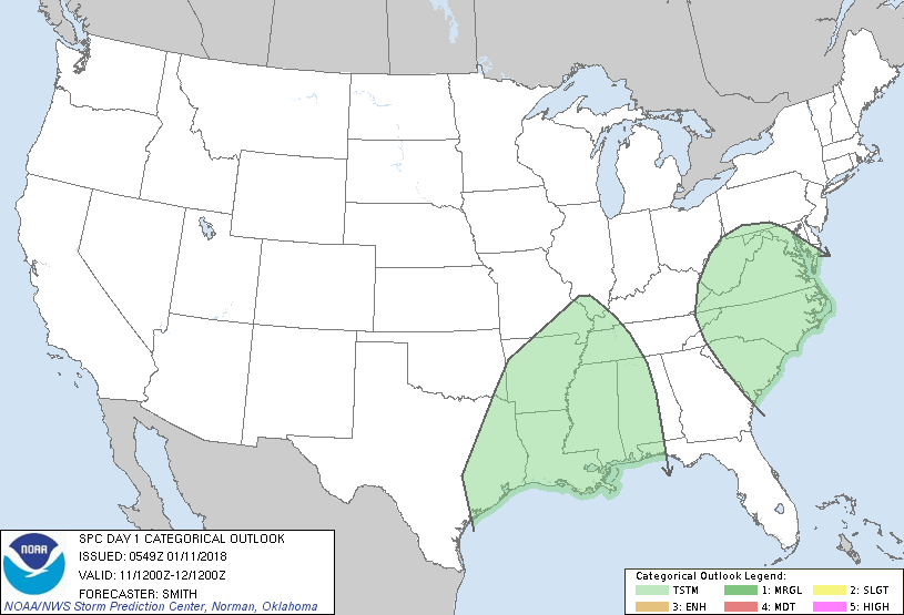
...NO SEVERE THUNDERSTORM AREAS FORECAST...
...SUMMARY...
Isolated to scattered thunderstorms are expected across parts of the
Gulf Coast and Mississippi Valley today and tonight. Elsewhere,
isolated thunderstorms will be possible across parts of the
Carolinas and Mid-Atlantic.
...Synopsis...
A large-scale mid-level trough over the central U.S. will slowly
move eastward from the Great Plains into the MS Valley by Friday
morning. A shortwave trough located in the base of the larger-scale
trough will translate east from the TX Rio Grande Valley to the
central Gulf Coast. Concurrently, a cold front extending from low
pressure over the upper Great Lakes southwestward through the
southern Plains will slide east-southeastward and push through much
of the Great Lakes/OH Valley and through the western Gulf Basin
during the period.
...TX/LA Sabine Valley eastward into the lower MS Valley...
Southerly low-level flow ahead of the approaching front will advect
moisture northward into the Gulf coastal plain during the day. As
stronger large-scale ascent/DCVA associated with the shortwave
trough encounters a moist/weakly unstable airmass, showers and
isolated thunderstorms are expected to develop over parts of
southeast/east TX during the late morning. Forecast soundings show
moist profiles in the lowest several km with weak lapse rates. Some
weak diurnal destabilization will occur and yield scant buoyancy
(50-250 J/kg MLCAPE). As the mid- to high-level flow/forcing for
ascent strengthens, the thunderstorms are forecast to grow upscale
into a broken band during the afternoon near the Sabine River and
develop east. Model guidance is showing only a modest LLJ (850mb
flow around 30-35 kt) with the stronger flow largely above 600mb.
As such, it appears some weak organization to the convective band
may occur, which could lead to a stronger storm (localized strong
gust). However, the presence of weak lapse rates and relatively
modest strength of flow in the low levels (available for momentum
transport) appear as limiting factors for an otherwise relatively
greater risk in thunderstorm (marginally severe) potential. This
activity will move east across the central Gulf Coast during the
overnight amidst weak lapse rates.
..Smith.. 01/11/2018
CLICK TO GET WUUS01 PTSDY1 PRODUCT
NOTE: THE NEXT DAY 1 OUTLOOK IS SCHEDULED BY 1300Z
|