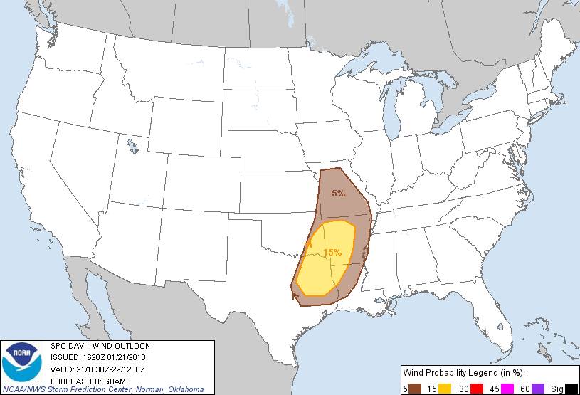
Probability of damaging thunderstorm winds or wind gusts of 50 knots or higher within 25 miles of a point. Hatched Area: 10% of greater probability of wind gusts 65 knots or greater within 25 miles of a point.
Day 1 Wind Risk
Area (sq. mi.)
Area Pop.
Some Larger Population Centers in Risk Area
15 %
76,780
5,434,709
Garland, TX...Shreveport, LA...Little Rock, AR...Mesquite, TX...Tyler, TX...
5 %
105,868
8,708,526
Dallas, TX...Kansas City, MO...Plano, TX...Irving, TX...Springfield, MO...
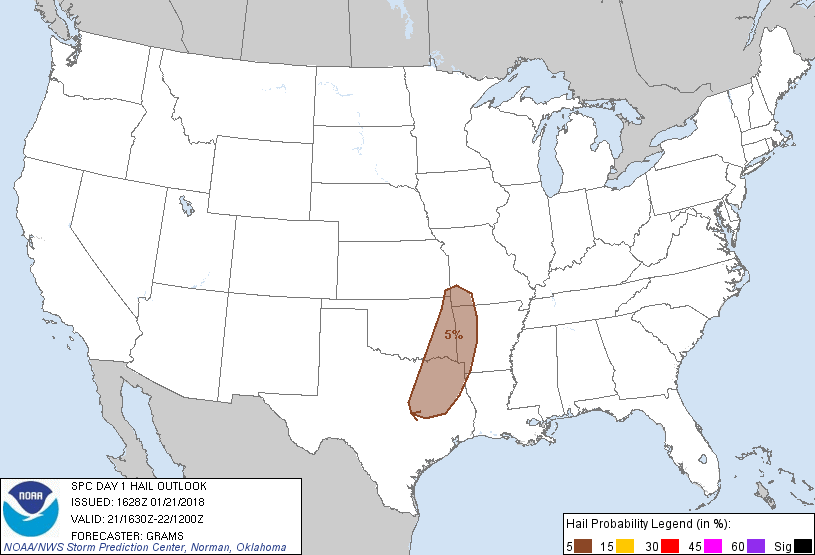
Probabilistic Large Hail Graphic
Probability of hail 1" or larger within 25 miles of a point. Hatched Area: 10% or greater probability of hail 2" or larger within 25 miles of a point.
SPC AC 211628
Day 1 Convective Outlook
NWS Storm Prediction Center Norman OK
1028 AM CST Sun Jan 21 2018
Valid 211630Z - 221200Z
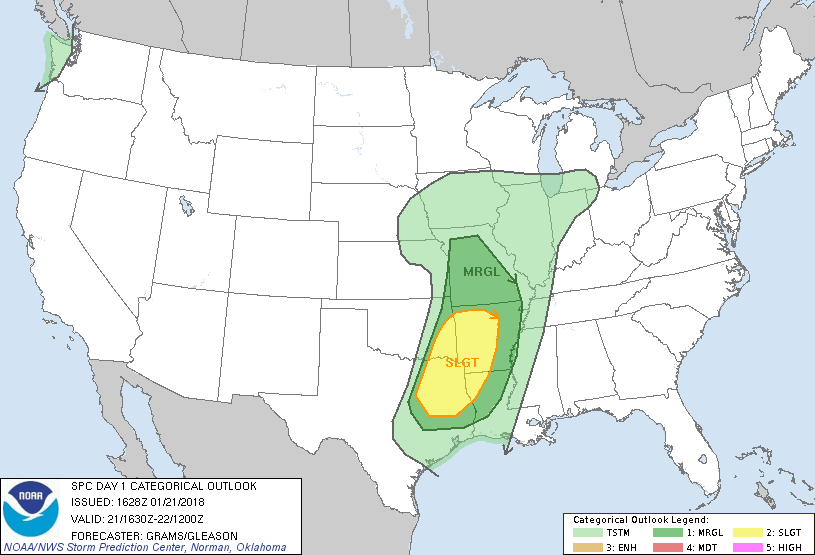
...THERE IS A SLIGHT RISK OF SEVERE THUNDERSTORMS EAST TX/OK TO AR
AND NORTHWEST LA...
...THERE IS A MARGINAL RISK OF SEVERE THUNDERSTORMS MO SOUTH TO
PARTS OF TX/LA...
...SUMMARY...
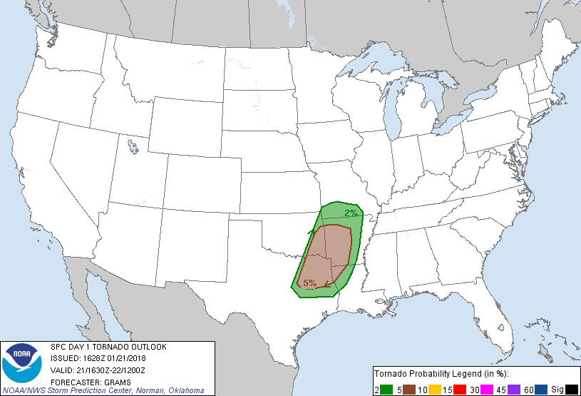
Scattered severe storms are likely after 4 PM CST, mainly from parts
of east Texas/Oklahoma into Arkansas and northwest Louisiana. A few
tornadoes, damaging winds, and isolated large hail will be possible.
...East TX/OK to AR/LA...
Overall minor changes to the SLGT and MRGL risks in this region.
Considered an upgrade to ENH centered on Texarkana but continued
concerns over the degree of buoyancy and potential weakness in
forecast hodographs around 700 mb suggest the tornado threat may not
yet warrant greater probabilities.
12Z soundings sampled mean mixing ratios of 10-12 g/kg within the
modifying western Gulf air mass that is characterized by surface dew
points of 60-65 F. These dew points should spread as far north as
eastern OK and western/southern AR during the afternoon/evening.
Abundant low cloud cover will limit diabatic surface heating within
the moist sector. However, low-level convergence will intensify
along the dryline during the late afternoon as mid-level height
falls associated with the southern Rockies shortwave trough
overspread the boundary. This should yield storms gradually
increasing along/ahead of the dryline across eastern OK into
east-central TX.
Forecast soundings show modest low/middle-level lapse rates across
much of the moist sector. Nearly saturated low-level thermodynamic
profiles should result in predominant MLCAPE values of 300-800 J/kg.
Low-level and deep-layer shear will strengthen tonight and become
increasingly favorable for updraft rotation, however some forecast
soundings indicate weaknesses in the hodograph around 700 mb. Given
the positive tilt of the mid/upper wave, the related geometry of
winds aloft should lead to a substantial component of mean flow
parallel to the developing convective corridor. These factors should
contribute to a mixed mode of semi-discrete cells transitioning to a
largely quasi-linear mode. Damaging winds should be the primary
hazard, but a few tornadoes are possible, particularly centered from
northeast TX into southeast OK and southwest AR between 00-06Z where
the combination of buoyancy/shear should be relatively maximized.
A broken band of storms will likely expand/develop slowly eastward
towards southern MO through the Sabine Valley tonight. The severe
threat should diminish towards the Lower MS Valley during the early
morning as the warm sector narrows from north to south ahead of the
convective band, though isolated damaging wind potential may persist
through 09-12Z.
...MO...
Relative to areas farther south, colder midlevel temperatures will
offset weaker boundary-layer theta-e to maintain weak buoyancy for
storms, amid an intense warm-advection conveyor. Forecast soundings
suggest MLCAPE will be meager, below 500 J/kg along and south of the
warm front in the 00-06Z time frame. A shallow, near-surface stable
layer reinforced by sporadic precip should temper downdraft strength
somewhat. Still, convective downward momentum transfer and related
isolated damaging winds may penetrate that layer. Low wind
probabilities have been maintained in this regime of favorably
strong deep-layer lift and weak buoyancy immediately preceding the
ejecting low-level cyclone.
..Grams/Gleason.. 01/21/2018
CLICK TO GET WUUS01 PTSDY1 PRODUCT
NOTE: THE NEXT DAY 1 OUTLOOK IS SCHEDULED BY 2000Z