Pine Bluff, AR...Monroe, LA...Greenville, MS...Hot Springs, AR...Texarkana, TX...
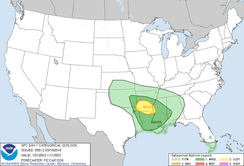
MARGINAL
108,609
6,708,210
Baton Rouge, LA...Shreveport, LA...Little Rock, AR...Jackson, MS...Lafayette, LA...
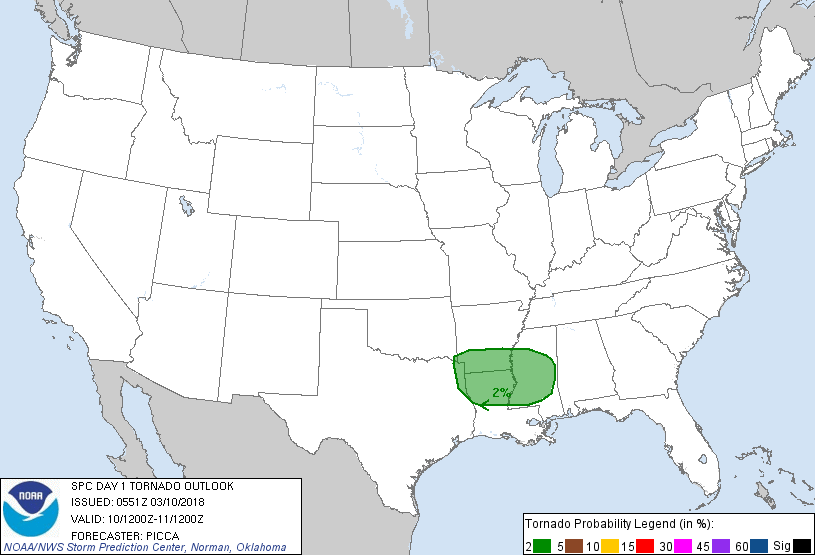
Probabilistic Tornado Graphic
Probability of a tornado within 25 miles of a point. Hatched Area: 10% or greater probability of EF2 - EF5 tornadoes within 25 miles of a point.
Day 1 Tornado Risk
Area (sq. mi.)
Area Pop.
Some Larger Population Centers in Risk Area
2 %
62,848
3,053,980
Shreveport, LA...Jackson, MS...Bossier City, LA...Monroe, LA...Alexandria, LA...
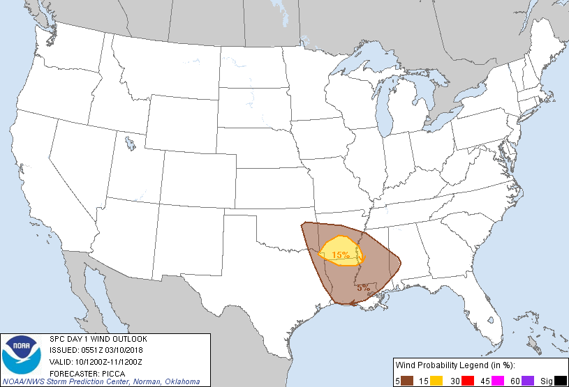
Probabilistic Damaging Wind Graphic
Probability of damaging thunderstorm winds or wind gusts of 50 knots or higher within 25 miles of a point. Hatched Area: 10% of greater probability of wind gusts 65 knots or greater within 25 miles of a point.
Day 1 Wind Risk
Area (sq. mi.)
Area Pop.
Some Larger Population Centers in Risk Area
15 %
24,677
1,212,479
Pine Bluff, AR...Monroe, LA...Greenville, MS...Hot Springs, AR...Texarkana, TX...
5 %
112,039
6,746,197
Baton Rouge, LA...Shreveport, LA...Little Rock, AR...Jackson, MS...Lafayette, LA...
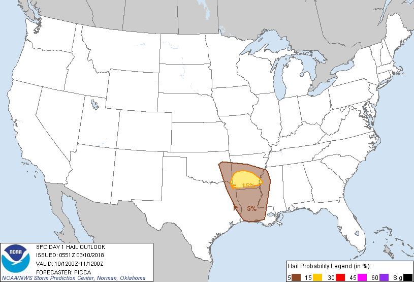
Probabilistic Large Hail Graphic
Probability of hail 1" or larger within 25 miles of a point. Hatched Area: 10% or greater probability of hail 2" or larger within 25 miles of a point.
Day 1 Hail Risk
Area (sq. mi.)
Area Pop.
Some Larger Population Centers in Risk Area
15 %
19,709
941,328
Pine Bluff, AR...Greenville, MS...Hot Springs, AR...Texarkana, TX...Texarkana, AR...
5 %
85,433
5,270,750
Baton Rouge, LA...Shreveport, LA...Little Rock, AR...Lafayette, LA...Fort Smith, AR...
   SPC AC 100551

   Day 1 Convective Outlook
   NWS Storm Prediction Center Norman OK
   1151 PM CST Fri Mar 09 2018

   Valid 101200Z - 111200Z

   ...THERE IS A SLIGHT RISK OF SEVERE THUNDERSTORMS FROM THE ARKLATEX
   TO THE LOWER MISSISSIPPI VALLEY...

   ...THERE IS A MARGINAL RISK OF SEVERE THUNDERSTORMS FROM EASTERN
   OKLAHOMA TO WESTERN ALABAMA...

   ...SUMMARY...
   A few strong to severe thunderstorms are possible across parts of
   the Arklatex and lower Mississippi Valley, primarily Saturday
   evening into the overnight.

   ...Synopsis...
   Relatively zonal mid-level flow will be established across the
   southern US today. Embedded in this flow, a series of low-amplitude
   impulses will advance eastward from the southern Plains to the
   Southeast. By Saturday night, a more notable, positively tilted
   shortwave trough will drop southeast over the central Plains, with
   an expansion of convection expected from eastern Oklahoma into
   Arkansas (discussed in more detail below).

   ...Arklatex and lower Mississippi Valley...
   At the beginning of the period, isolated to widely scattered
   convection may be ongoing near the upper Texas/Louisiana coast,
   owing to modest warm advection and boundary-layer confluence coupled
   with continued northward theta-e return. Most likely, the strongest
   convection will be focused near/offshore the coast, with weaker
   cells farther inland. Nonetheless, ample effective shear and steep
   mid-level lapse rates (offering around 1000 J/kg of MUCAPE) may
   support isolated marginally severe hail in deeper cells. Moreover,
   while inland low-level destabilization will likely be stunted some
   by offshore convection, near-surface stability will not be
   particularly deep/strong, such that an isolated damaging gust or two
   could occur.

   A lull in activity may then occur during the afternoon, prior to
   convection organizing across far eastern Oklahoma and Arkansas by
   evening. As a secondary mid-level speed max approaches the region,
   increasing warm-air advection around 850-700mb will focus
   thunderstorm activity near a trough extending from Oklahoma east to
   the Mississippi Valley. A residual elevated mixed layer, coupled
   with robust mid/upper west/northwesterly winds, will yield a threat
   for a few severe hail reports during the evening and overnight.
   Additionally, relatively straight hodographs above approximately 1
   km may encourage a few southeastward-accelerating bands capable of
   strong/damaging winds. Lastly, despite relaxed low-level flow, a
   brief tornado could occur within backed surface winds near/ahead of
   a weak frontal wave advancing from the Arklatex to the Mid-South
   through the overnight.

   ..Picca/Cook.. 03/10/2018

   CLICK TO GET WUUS01 PTSDY1 PRODUCT

   NOTE: THE NEXT DAY 1 OUTLOOK IS SCHEDULED BY 1300Z