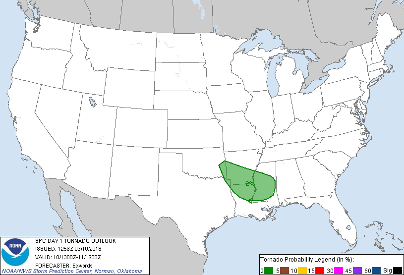
Probability of a tornado within 25 miles of a point. Hatched Area: 10% or greater probability of EF2 - EF5 tornadoes within 25 miles of a point.
Day 1 Tornado Risk
Area (sq. mi.)
Area Pop.
Some Larger Population Centers in Risk Area
2 %
72,435
3,670,544
Shreveport, LA...Jackson, MS...Fort Smith, AR...Bossier City, LA...Pine Bluff, AR...
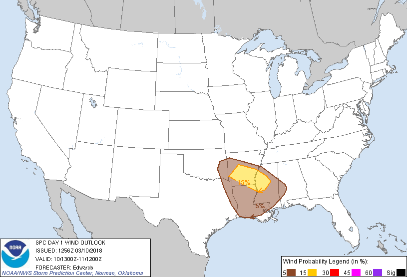
Probabilistic Damaging Wind Graphic
Probability of damaging thunderstorm winds or wind gusts of 50 knots or higher within 25 miles of a point. Hatched Area: 10% of greater probability of wind gusts 65 knots or greater within 25 miles of a point.
Day 1 Wind Risk
Area (sq. mi.)
Area Pop.
Some Larger Population Centers in Risk Area
15 %
32,826
1,721,687
Little Rock, AR...North Little Rock, AR...Pine Bluff, AR...Greenville, MS...Hot Springs, AR...
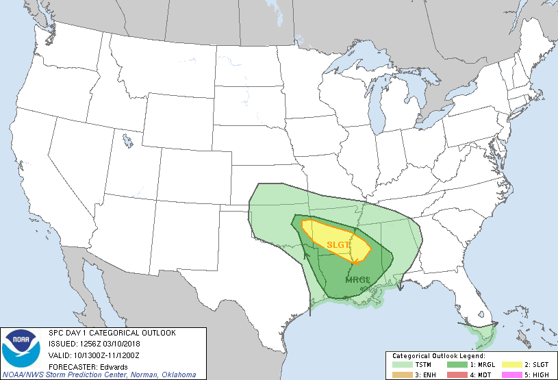
   SPC AC 101256

   Day 1 Convective Outlook
   NWS Storm Prediction Center Norman OK
   0656 AM CST Sat Mar 10 2018

   Valid 101300Z - 111200Z

   ...THERE IS A SLIGHT RISK OF SEVERE THUNDERSTORMS FROM PARTS OF
   EASTERN OK TO PARTS OF WESTERN/CENTRAL MISSISSIPPI...

   ...THERE IS A MARGINAL RISK OF SEVERE THUNDERSTORMS SURROUNDING THE
   MARGINAL RISK AND EXTENDING TO SOUTHERN LOUISIANA AND PARTS OF
   WESTERN ALABAMA...

   ...SUMMARY...
   Strong to severe thunderstorms are possible across parts of eastern
   Oklahoma and the Arklatex and lower Mississippi Valley, primarily
   this evening and overnight.

   ...Synopsis...
   In mid/upper levels, a split-flow pattern will evolve across the
   western/central U.S.  A strong shortwave trough -- initially located
   over the northern High Plains -- is forecast to dig southeastward to
   the central Plains and lower Missouri Valley region by the end of
   the period, with an intermittently closed/embedded 500-mb low
   possible.  Upstream ridge amplification is expected across the
   northern/Canadian Rockies.  Meanwhile, a cluster of closely spaced
   shortwave troughs over the northeastern Pacific will move inland,
   leading to an "undercutting" branch of westerlies south of the
   ridge, across the UT/AZ region, by 12Z.  An even more closely spaced
   grouping of vorticity maxima now over the northwestern Gulf -- some
   convectively generated/reinforced and some originating from the
   Pacific southern stream -- will proceed across south FL and the Keys
   this evening.  Associated large-scale ascent/destabilization aloft,
   atop the northern fringes of a residual frontal zone, will
   contribute to general thunderstorm potential there.

   At the surface, a weak frontal-wave low was analyzed over the area
   between SPS-LTS-CDS, with weak and very slowly moving cold front
   southwestward across the southern South Plains region and
   southeastern NM.  A wavy/quasistationary baroclinic zone was
   analyzed from the low across south-central/northeastern OK, the
   Ozarks, and southern KY.  A dryline was drawn from a frontal
   intersection just northeast of the low, in southwestern OK, to just
   west of both DYS and 6R6.  A marine/warm front extended across the
   Gulf shelf waters of LA and extreme southeast TX to near GLS,
   becoming diffuse westward over south-central TX.  Cold frontogenesis
   -- now underway over the northern High Plains near the mid/upper-
   level trough -- will move southeastward through the period and
   overtake the southern Plains frontal zone/low around 06Z.  By 12Z, a
   new/weak frontal-wave low should develop over the southeastern
   AR/western MS region, with cold front across northern LA and
   east-central/south-central TX.  The dryline should remain capped and
   largely irrelevant to convective risk for this outlook, before it is
   overtaken by the northern frontal surge.

   ...Eastern OK to lower Mississippi Valley and LA...
   An initial round of thunderstorms -- including at least one
   persistent supercell and other strong/possibly severe convection --
   evolved and persisted the past few hours over the Gulf, south of the
   upper TX coast.  This activity has been related in part to the
   passing cluster of vorticity maxima, the marine frontal zone, and a
   inflow of an optimally high-thetae/low-CINH boundary layer in the
   best-modified part of the warm sector.  This convection -- which has
   exhibited severe-hail MESH markers and well-defined mesocyclones in
   radar imagery -- should remain over the Gulf amidst ambient
   west-northwesterly mid/upper-level flow.  Still, it illustrates the
   presence of favorable deep shear already over the region.

   Another round of thunderstorms with marginal severe potential may
   develop through midday local time across parts of LA, and move into
   western MS this afternoon, initially in a regime of elevated inflow
   northeast of the marine front.  Isolated, marginally severe hail
   will be the main concern with this activity, which will occur in a
   regime of strengthening low-level theta-e but weak near-surface
   flow, limiting hodograph size.  Favorable deep shear is expected,
   with forecast soundings showing MUCAPE generally 500-800 J/kg,
   limited by weak lapse rates aloft.  Diurnal/diabatic
   destabilization, combined with boundary-layer warm advection, may
   render nearly surface-based effective inflow parcels to some of this
   activity before it moves into more stable air and weakens over
   central/eastern MS late this afternoon.

   The main/best-organized convective episode is expected to occur this
   evening into overnight with initiation near the wavy/quasistationary
   frontal zone, over the eastern OK/northwestern AR region, as large-
   scale lift and height falls start to impinge upon an area of at
   least modest low-level convergence, near the boundary-layer moist
   axis.  Initial mode should evolve to supercellular, right-moving
   southeastward to southeastward while offering large hail and
   isolated severe gusts.  With time and distance southeastward across
   AR, upscale growth to a quasi-linear MCS is expected, carrying a
   dominant threat of damaging wind across the Mississippi River and
   into parts of MS overnight before the complex begins to weaken.  A
   limiting factor for a better-organized/higher-magnitude threat of
   supercellular hail/tornadoes will be the lack of substantial low-
   level flow, limiting hodograph size.  Still, deep shear will be
   favorable for the evolution described above, with effective-shear
   magnitudes expected to reach the 45-60-kt range from late afternoon
   into that part of this evening prior to convective passage.

   ..Edwards.. 03/10/2018

   CLICK TO GET WUUS01 PTSDY1 PRODUCT

   NOTE: THE NEXT DAY 1 OUTLOOK IS SCHEDULED BY 1630Z