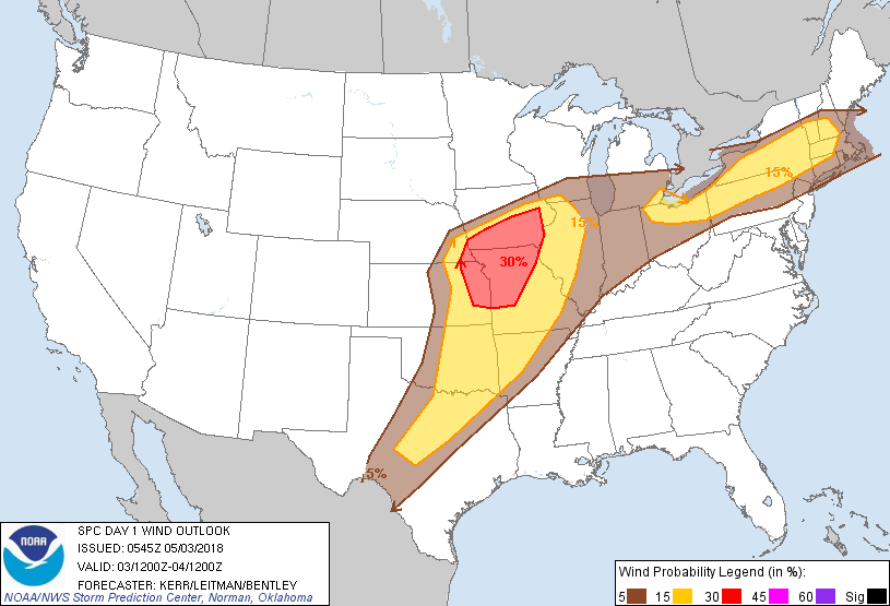
Probability of damaging thunderstorm winds or wind gusts of 50 knots or higher within 25 miles of a point. Hatched Area: 10% of greater probability of wind gusts 65 knots or greater within 25 miles of a point.
Day 1 Wind Risk
Area (sq. mi.)
Area Pop.
Some Larger Population Centers in Risk Area
30 %
61,313
4,668,833
Kansas City, MO...Des Moines, IA...Overland Park, KS...Kansas City, KS...Cedar Rapids, IA...
15 %
271,335
35,915,467
Dallas, TX...Fort Worth, TX...Oklahoma City, OK...Cleveland, OH...Omaha, NE...
5 %
271,136
65,135,965
New York, NY...Chicago, IL...Detroit, MI...Indianapolis, IN...Columbus, OH...
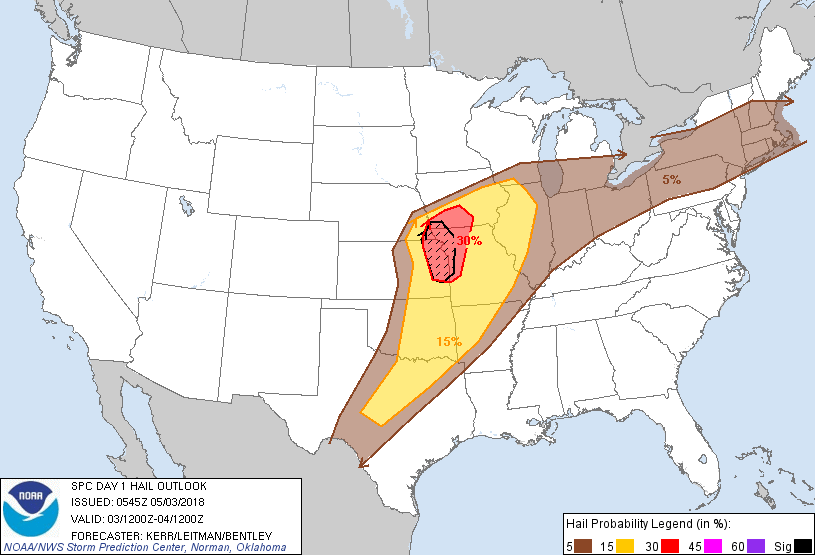
Probabilistic Large Hail Graphic
Probability of hail 1" or larger within 25 miles of a point. Hatched Area: 10% or greater probability of hail 2" or larger within 25 miles of a point.
Day 1 Hail Risk
Area (sq. mi.)
Area Pop.
Some Larger Population Centers in Risk Area
SIG SEVERE
18,847
2,564,732
Kansas City, MO...Overland Park, KS...Kansas City, KS...Topeka, KS...Olathe, KS...
30 %
35,830
3,396,583
Kansas City, MO...Des Moines, IA...Overland Park, KS...Kansas City, KS...Topeka, KS...
15 %
218,143
21,648,825
Dallas, TX...Fort Worth, TX...Oklahoma City, OK...Omaha, NE...Tulsa, OK...
5 %
348,079
80,504,154
New York, NY...Chicago, IL...Detroit, MI...Indianapolis, IN...Columbus, OH...
SPC AC 030545
Day 1 Convective Outlook
NWS Storm Prediction Center Norman OK
1245 AM CDT Thu May 03 2018
Valid 031200Z - 041200Z
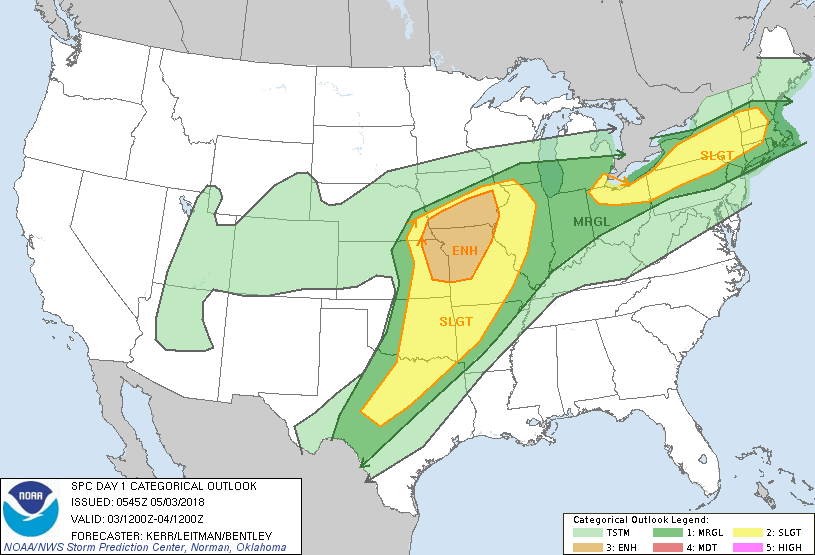
...THERE IS AN ENHANCED RISK OF SEVERE THUNDERSTORMS LATE THIS
AFTERNOON AND EVENING ACROSS THE LOWER MISSOURI/MIDDLE MISSISSIPPI
VALLEY REGION...
...THERE IS A SLIGHT RISK OF SEVERE THUNDERSTORMS ACROSS PARTS OF
THE LOWER GREAT LAKES AND ALLEGHENY PLATEAU INTO SOUTHERN NEW
ENGLAND...
...SUMMARY...
Severe thunderstorms are expected to impact the lower Missouri and
middle Mississippi Valley region late this afternoon and evening,
with additional severe thunderstorms possible in a corridor across
parts of the lower Great Lakes region into southern New England, as
well across parts of the southern Plains by late tonight.
...Synopsis...
Fairly strong mid/upper ridging within the subtropical and
mid-latitude westerlies appears likely to persist across much of the
southeastern U.S., while ridging also builds inland of the Pacific
coast through much of the Intermountain West. In between, troughing
may linger across portions of the Four Corner states, but the most
prominent impulse emerging from it appears likely to accelerate east
northeast of the Colorado Rockies today. As it does, it likely will
be accompanied by at least a modest surface frontal wave/low across
the central Plains through lower Missouri Valley region by early
this evening. More substantive deepening of the low may commence
late tonight across the Great Lakes region, when models suggest
increased phasing of its associated upper impulse with another short
wave impulse digging east southeast of the Canadian Prairies.
Although a plume of very warm elevated mixed layer air emanating
from the Mexican Plateau region is in the process of becoming at
least somewhat suppressed, mid-level lapse rates may remain modestly
steep across the central/southern Plains into Mississippi Valley
region. Coupled with continued low-level moistening on southerly
return flow around the Southeastern ridge, east of the southern
Plains dryline, and southeast of the frontal zone extending across
the central Plains through the Great Lakes region into portions of
the Northeast, sufficient destabilization likely will occur today to
support areas of strong/severe thunderstorm development.
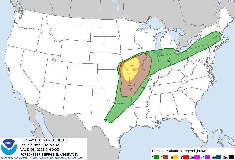
...Plains into lower Missouri/mid Mississippi Valley...
Remnant convection/cloud cover probably will at least slow warm
sector boundary layer destabilization early today into this
afternoon. However, beneath a developing mid-level dry slot
associated with the short wave impulse and accompanying 70-90 kt 500
mb jet, destabilization preceding stronger mid-level forcing for
ascent seems likely to provide the focus for the most certain severe
weather risk today. By late afternoon, this is expected across
parts of the lower central Plains into lower Missouri Valley, where
the environment may become conducive to discrete supercells capable
of producing large hail and a few tornadoes. It is possible that
this activity could grow upscale into an organizing convective
system with increasing potential for damaging wind gusts near the
Missouri/Iowa border vicinity through this evening, before weakening
in waning instability as it approaches the Great Lakes region
tonight.
Southward through the southern Plains, severe thunderstorm potential
during the peak late afternoon and evening hours may be more
isolated in the presence of weak forcing for ascent. However, it is
possible that strengthening ascent ahead of remnant upper troughing
may contribute to increasing thunderstorm activity with at least
some severe weather potential across parts of the Edwards Plateau
into central Texas late this evening into the overnight hours.
...Great Lakes adjacent Allegheny Plateau into New England...
Peak boundary layer destabilization along and just south of the
quasi-stationary surface frontal zone may be fairly modest
(generally on the order of 500-1000 J/kg) today. However, a belt of
30-50 kt lower/mid tropospheric flow with a number of small-scale
perturbations, well in advance of the main impulse emerging from the
Great Basin, may enhance afternoon and evening thunderstorm
development. Some of this may become capable of producing damaging
wind gusts.
..Kerr/Leitman/Bentley.. 05/03/2018
CLICK TO GET WUUS01 PTSDY1 PRODUCT
NOTE: THE NEXT DAY 1 OUTLOOK IS SCHEDULED BY 1300Z