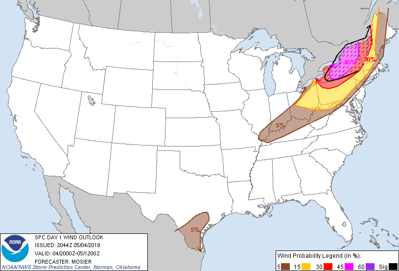
Probability of damaging thunderstorm winds or wind gusts of 50 knots or higher within 25 miles of a point. Hatched Area: 10% of greater probability of wind gusts 65 knots or greater within 25 miles of a point.
SPC AC 042044
Day 1 Convective Outlook CORR 1
NWS Storm Prediction Center Norman OK
0344 PM CDT Fri May 04 2018
Valid 042000Z - 051200Z
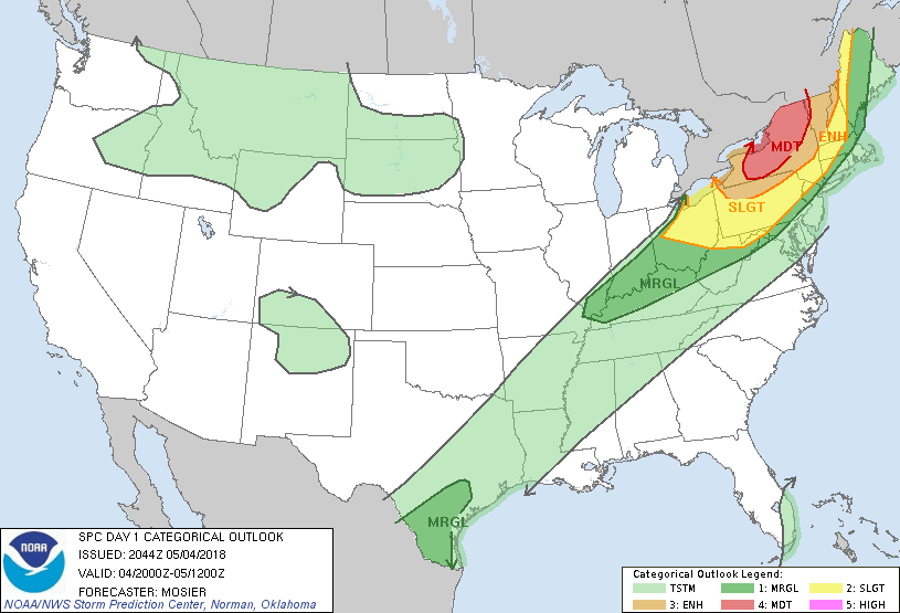
...THERE IS A MODERATE RISK OF SEVERE THUNDERSTORMS FROM WESTERN NY
INTO THE ADIRONDACKS...
CORRECTED FOR ERRORS IN CATEGORICAL GRAPHIC
...SUMMARY...
Severe thunderstorms are expected today east of the lower Great
Lakes into the upper Ohio Valley and western portions of New
England. This includes a threat for widespread damaging winds, as
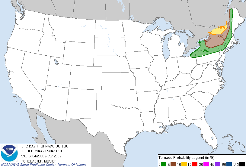
well as tornadoes across parts of New York and Vermont.
...NY/PA into New England...
Progressive, compact shortwave trough continues to move quickly
towards the Lower Great Lakes. Strong forcing for ascent along the
leading edge of this system has resulted in banded thunderstorm
development across Lower MI and adjacent portions of the Upper OH
Valley. Numerous severe gusts (i.e. greater than 50 kt) were
measured around the DTX as this line moved through. This convection
has weakened somewhat as it moves across the cool water of Lake Erie
but it is expected to re-intensify quickly once it moves into the
steep low-level lapse rate environment over western NY and the
Finger Lakes region. Additionally, storm coverage has increased
south of Lake Erie across northern OH, with this activity expected
to pose a downstream wind damage threat.
Given current storm and environmental trends, a swath of significant
wind gusts looks probable from BUF to BTV where very strong winds
(60 to 70 kt) will exist just above the surface (i.e. 500m to 1 km
AGL) over the next few hours. Recent BUF VAD sampled the leading
edge of this stronger flow, measuring 50 kt around 750m. Expectation
is for these winds to mix down as the convective line moves through.
As a result, 45% wind probabilities were delineated across the
region where the best overlap of convective coverage, steep
low-level lapse rates, and instability exists. This result in an
upgrade to Moderate Risk from western NY northeastward into the
Adirondacks.
As discussed in the previous outlook (appended below),
isolated/discrete cells are still possible over northeast NY as
favorable kinematics align with sufficient instability. Tornado
Watch 76 was recent issued to cover this threat. More short-term
details can be found in MCD 350.
...South TX...
Northeastern extent of the 5% wind probabilities across the region
was trimmed based on ongoing precipitation. Very moist and
moderately unstable environment over the remainder of the region
still supports the potential for a few damaging wind gusts.
..Mosier.. 05/04/2018
.PREV DISCUSSION... /ISSUED 1112 AM CDT Fri May 04 2018/
...NY/PA into New England...
Morning water vapor loop shows a very strong, compact, and
progressive shortwave trough moving eastward across MI. This
feature will track rapidly eastward across NY/PA this afternoon.
Impressive mid-level height falls will occur across this region this
afternoon and evening, promoting thunderstorm development along and
ahead of the approaching cold front. Wind fields will rapidly
strengthen through the day, indicating the potential for a rather
widespread damaging wind event, including a few tornadoes across the
ENH risk area. This threat appears to be in two distinct waves.
The first area of risk today will be as isolated/discrete cells form
this afternoon in vicinity of the surface warm front over northeast
NY near the US/Canadian border, and with less confidence farther
south across eastern NY/ and much of VT/NH. Forecast soundings show
only marginally favorable thermodynamic parameters. However,
low-level winds will be very strong with large, looping hodographs.
If convection can remain discrete for awhile, an enhanced tornado
threat will develop in this area. These storms will track eastward
into western ME before weakening this evening.
Farther west, 12z model solutions are consistent in the development
of a fast moving squall line along the front that will race across
the ENH area this afternoon and evening. Given the intense wind
fields (50-60 knots just above the surface), widespread damaging
winds are possible including significant wind damage. If the squall
line can attain sufficient mesoscale organization, the environment
also supports QLCS tornadoes. These storms will affect much of NY
and parts of northern PA before sweeping into VT/NH and parts of
western ME/MA this evening. Marginal thermodynamic parameters are
the primary mitigating factor for a categorical upgrade.
...TX...
A long-lived thunderstorm complex over central TX will likely
persist through the afternoon, sagging southeastward. Strong
heating ahead of the leading edge of storms will promote isolated
strong cells capable of gusty winds. At this time, it appears
unlikely that a more organized severe risk will develop. Therefore
will maintain only MRGL risk.
CLICK TO GET WUUS01 PTSDY1 PRODUCT
NOTE: THE NEXT DAY 1 OUTLOOK IS SCHEDULED BY 0100Z