Kansas City, MO...Omaha, NE...Lincoln, NE...Des Moines, IA...Overland Park, KS...
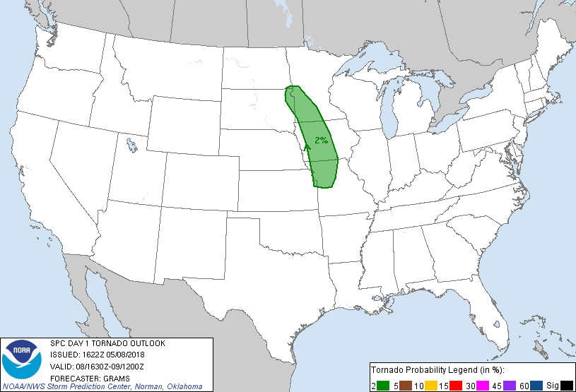
Probabilistic Tornado Graphic
Probability of a tornado within 25 miles of a point. Hatched Area: 10% or greater probability of EF2 - EF5 tornadoes within 25 miles of a point.
Day 1 Tornado Risk
Area (sq. mi.)
Area Pop.
Some Larger Population Centers in Risk Area
2 %
64,100
3,945,311
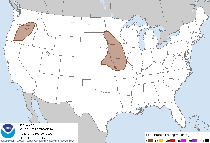
Kansas City, MO...Des Moines, IA...Overland Park, KS...Kansas City, KS...Olathe, KS...
Probabilistic Damaging Wind Graphic
Probability of damaging thunderstorm winds or wind gusts of 50 knots or higher within 25 miles of a point. Hatched Area: 10% of greater probability of wind gusts 65 knots or greater within 25 miles of a point.
Day 1 Wind Risk
Area (sq. mi.)
Area Pop.
Some Larger Population Centers in Risk Area
5 %
158,292
7,594,843
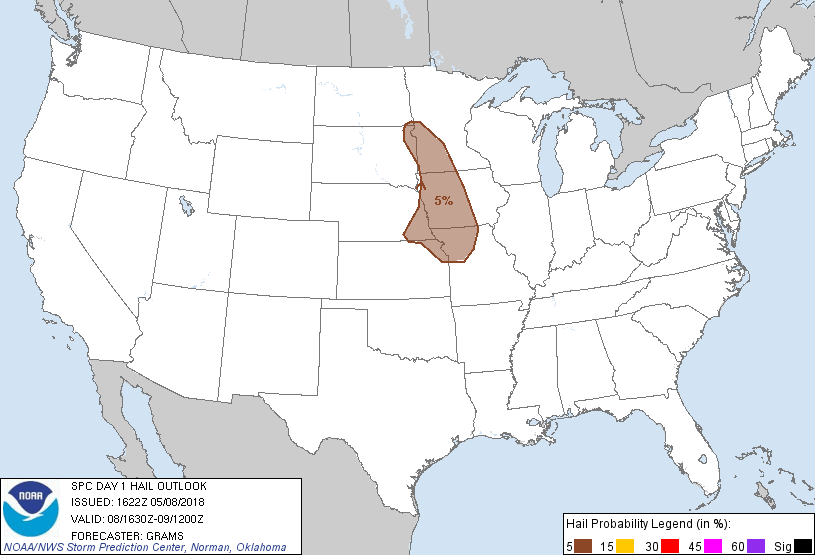
Kansas City, MO...Omaha, NE...Lincoln, NE...Des Moines, IA...Overland Park, KS...
Probabilistic Large Hail Graphic
Probability of hail 1" or larger within 25 miles of a point. Hatched Area: 10% or greater probability of hail 2" or larger within 25 miles of a point.
Day 1 Hail Risk
Area (sq. mi.)
Area Pop.
Some Larger Population Centers in Risk Area
5 %
80,549
5,185,720
Kansas City, MO...Omaha, NE...Lincoln, NE...Des Moines, IA...Overland Park, KS...
SPC AC 081622
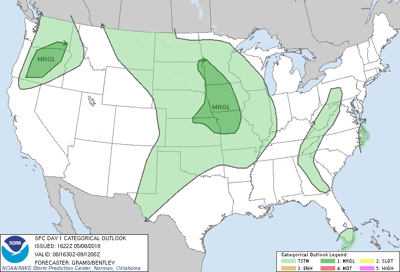
Day 1 Convective Outlook
NWS Storm Prediction Center Norman OK
1122 AM CDT Tue May 08 2018
Valid 081630Z - 091200Z
...THERE IS A MARGINAL RISK OF SEVERE THUNDERSTORMS UPPER MIDWEST TO
LOWER MO VALLEY...
...SUMMARY...
Isolated severe storms are possible from the Upper Minnesota Valley
south to the Lower Missouri Valley, and across parts of Oregon
during the late afternoon and evening.
..Upper MN Valley to Lower MO Valley...
A cluster of warm advection-driven convection is ongoing across
parts of the Siouxland. This activity should diminish as warm
advection decreases into this afternoon. However, convection should
redevelop late afternoon into this evening along the trailing
outflow/warm front intersection expected to lie across the northwest
IA portion of the MO Valley. Additional storms may form farther
north near the surface cyclone that will drift from northeast SD
into the MN Valley, and farther south across parts of MO near the
warm front.
With a lack of a connection to richer boundary-layer moisture over
the southwest Gulf, mixed surface dew points should remain in the
50s across the warm sector. This should result in relatively large
surface temperature/dew point spreads south of the ongoing
convective cluster. Deep-layer shear of 20-30 kts will also limit
sustained supercells across much of the Mid/Lower MO Valley owing to
the low-amplitude nature of the SD shortwave trough and modest
mid/upper-level winds. The presence of a southerly low-level jet
that will restrengthen this evening will support enlarged hodographs
near the surface warm front. Convective mode should quickly evolve
into multicell clusters with potential for a few embedded transient
low-level mesocyclones. Such a setup will tend to favor isolated
damaging winds as the primary overall hazard, with isolated severe
hail favored in the initial development stage, along with a risk for
a brief tornado or two near the warm front. While convection will
likely persist into the overnight and become increasingly elevated
east of the surface warm front, an increasingly marginal CAPE/shear
combination should result in the severe-storm threat waning tonight.
...OR...
A shortwave trough off the Pacific Northwest Coast will brush the WA
Coast tonight, aiding in the breakdown of the upper ridge. Meager
buoyancy atop a deep mixed layer should be supportive of a few
strong, high-based storms east of the Cascades during the late
afternoon and evening. While mid/upper-level speed shear will
strengthen with approach of the trough, effective shear will likely
remain on the margins for organized storms given the lack of larger
buoyancy. Isolated strong to severe wind gusts should be the primary
hazard, enhanced by evaporative effects within the dry sub-cloud
boundary layer. Risk for severe weather should wane after sunset as
inhibition rapidly increases.
..Grams/Bentley.. 05/08/2018
CLICK TO GET WUUS01 PTSDY1 PRODUCT
NOTE: THE NEXT DAY 1 OUTLOOK IS SCHEDULED BY 2000Z