Philadelphia, PA...Baltimore, MD...Washington, DC...Virginia Beach, VA...Newark, NJ...
MARGINAL
260,574
38,432,443
New York, NY...Charlotte, NC...Omaha, NE...Raleigh, NC...Lincoln, NE...
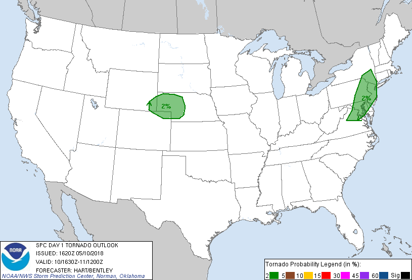
Probabilistic Tornado Graphic
Probability of a tornado within 25 miles of a point. Hatched Area: 10% or greater probability of EF2 - EF5 tornadoes within 25 miles of a point.
Day 1 Tornado Risk
Area (sq. mi.)
Area Pop.
Some Larger Population Centers in Risk Area
2 %
77,917
35,929,414
New York, NY...Philadelphia, PA...Baltimore, MD...Washington, DC...Newark, NJ...
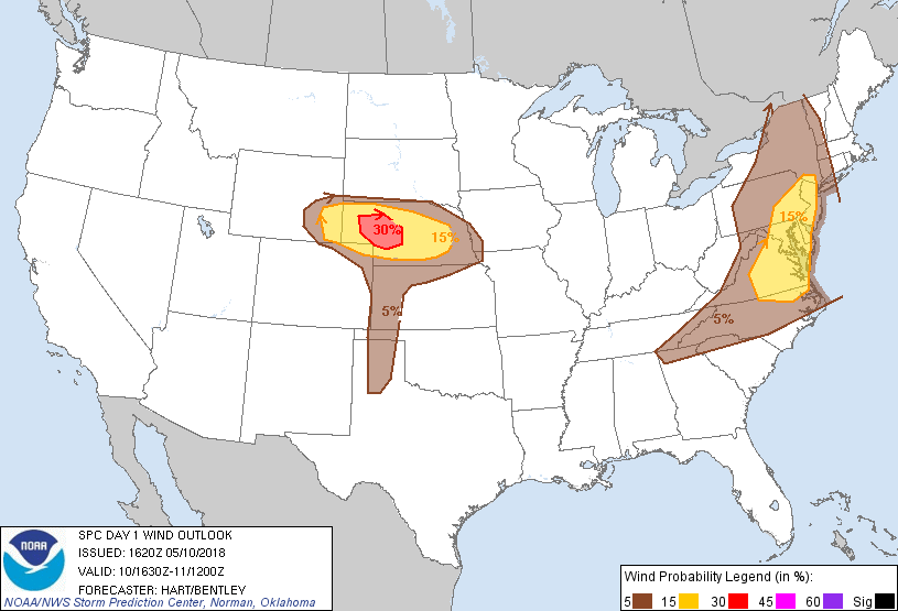
Probabilistic Damaging Wind Graphic
Probability of damaging thunderstorm winds or wind gusts of 50 knots or higher within 25 miles of a point. Hatched Area: 10% of greater probability of wind gusts 65 knots or greater within 25 miles of a point.
New York, NY...Charlotte, NC...Virginia Beach, VA...Omaha, NE...Raleigh, NC...
Probabilistic Large Hail Graphic
Probability of hail 1" or larger within 25 miles of a point. Hatched Area: 10% or greater probability of hail 2" or larger within 25 miles of a point.
Day 1 Hail Risk
Area (sq. mi.)
Area Pop.
Some Larger Population Centers in Risk Area
30 %
11,608
54,568
North Platte, NE...
15 %
53,157
605,355
Cheyenne, WY...Grand Island, NE...Kearney, NE...Norfolk, NE...Hastings, NE...
5 %
257,966
52,534,198
New York, NY...Philadelphia, PA...Baltimore, MD...Charlotte, NC...Washington, DC...
SPC AC 101620
Day 1 Convective Outlook
NWS Storm Prediction Center Norman OK
1120 AM CDT Thu May 10 2018
Valid 101630Z - 111200Z
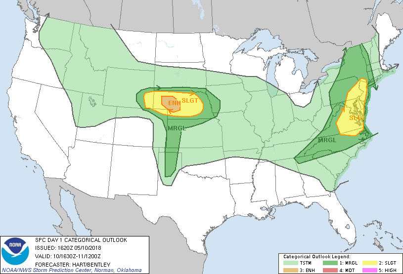
...THERE IS AN ENHANCED RISK OF SEVERE THUNDERSTORMS OVER PARTS OF
NEBRASKA...
...THERE IS A SLIGHT RISK OF SEVERE THUNDERSTORMS ACROSS PORTIONS OF
THE MID ATLANTIC REGION...AND THE CENTRAL HIGH PLAINS...
...SUMMARY...
Afternoon severe thunderstorms will produce large hail and damaging
winds over parts of the central Plains states. A few severe storms
capable of damaging winds are also expected to affect portions of
the Mid-Atlantic to southern Appalachians.
...Central Plains...
Water vapor loop shows a upper ridge centered over the central
Rockies, with an low-amplitude upper trough over the western states.
This trough will spread eastward today, with large-scale forcing
affecting parts of the central High Plains. Easterly post-frontal
surface winds are present across much of NE and eastern WY, where
40s and 50s dewpoints are being slowly transported westward. This
combined with strong daytime heating will yield afternoon MLCAPE
values around 1000 J/kg in southeast WY, and approaching 2000 J/kg
farther east in western NE.
Present indications are that thunderstorms will intensify this
afternoon to the east of the Laramie range and track eastward into
the adjacent plains of western NE. Initial storms will likely have
supercellular characteristics due to favorable low level
shear/hodographs. An isolated tornado or two is possible, but
greater threat appears to be large hail and damaging wind gusts
today. Storms are expected to grow upscale though the evening with
numerous CAM solutions suggesting bowing storm structures and an
increasing risk of damaging wind gusts.
...Mid Atlantic...
Morning clouds/precipitation are slowly decreasing, allowing pockets
of strong afternoon heating over portions of VA/MD. This area will
see re-development of thunderstorms by mid afternoon along/ahead the
cold front currently over WV. Local VAD and forecast soundings
suggest sufficiently steep low-level lapse rates and wind fields to
pose a risk of damaging wind gusts in the stronger cells. Isolated
severe hail is also possible.
Farther north, clouds are holding firm over eastern PA, NJ, and
southeast NY. Wind fields are stronger in this area than farther
south, but weaker thermodynamics are a mitigating factor. Have
trimmed the SLGT risk in NY, but will maintain across eastern PA/NJ
where some heating may occur later today.
..Hart/Bentley.. 05/10/2018
CLICK TO GET WUUS01 PTSDY1 PRODUCT
NOTE: THE NEXT DAY 1 OUTLOOK IS SCHEDULED BY 2000Z