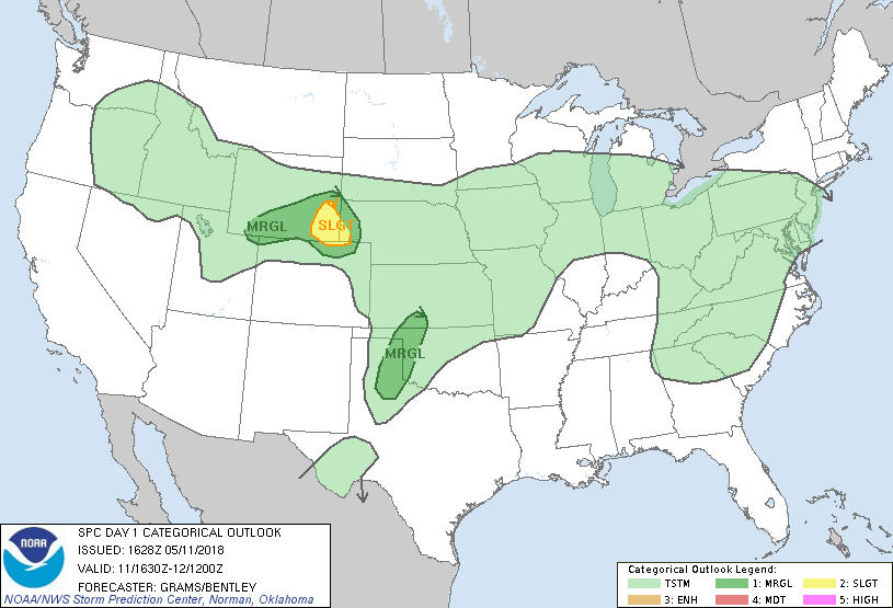
Fort Collins, CO...Greeley, CO...Casper, WY...Evans, CO...Rock Springs, WY...
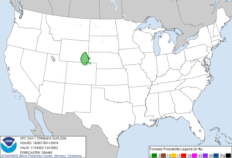
Probabilistic Tornado Graphic
Probability of a tornado within 25 miles of a point. Hatched Area: 10% or greater probability of EF2 - EF5 tornadoes within 25 miles of a point.
Day 1 Tornado Risk
Area (sq. mi.)
Area Pop.
Some Larger Population Centers in Risk Area
2 %
12,208
168,716
Cheyenne, WY...Laramie, WY...Torrington, WY...
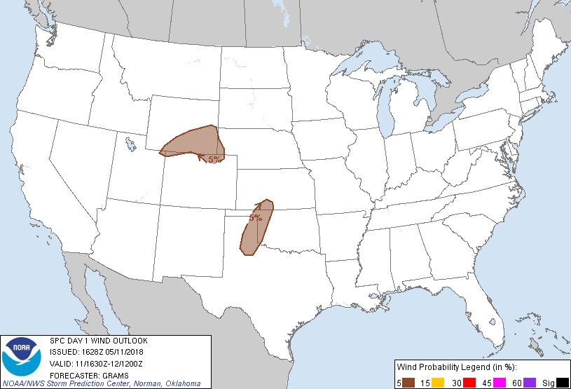
Probabilistic Damaging Wind Graphic
Probability of damaging thunderstorm winds or wind gusts of 50 knots or higher within 25 miles of a point. Hatched Area: 10% of greater probability of wind gusts 65 knots or greater within 25 miles of a point.
Day 1 Wind Risk
Area (sq. mi.)
Area Pop.
Some Larger Population Centers in Risk Area
5 %
63,643
706,335
Fort Collins, CO...Greeley, CO...Cheyenne, WY...Laramie, WY...Evans, CO...
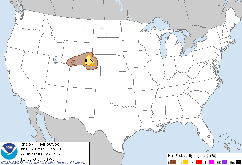
Probabilistic Large Hail Graphic
Probability of hail 1" or larger within 25 miles of a point. Hatched Area: 10% or greater probability of hail 2" or larger within 25 miles of a point.
Day 1 Hail Risk
Area (sq. mi.)
Area Pop.
Some Larger Population Centers in Risk Area
SIG SEVERE
4,486
16,475
No Major Population Center in Risk Area
15 %
12,530
186,844
Cheyenne, WY...Laramie, WY...Torrington, WY...
5 %
37,279
556,591
Fort Collins, CO...Greeley, CO...Casper, WY...Evans, CO...Rock Springs, WY...
   SPC AC 111628

   Day 1 Convective Outlook
   NWS Storm Prediction Center Norman OK
   1128 AM CDT Fri May 11 2018

   Valid 111630Z - 121200Z

   ...THERE IS A SLIGHT RISK OF SEVERE THUNDERSTORMS SOUTHEAST WY
   VICINITY...

   ...SUMMARY...
   A few severe storms with large hail as the primary hazard are most
   likely to occur across the central High Plains this afternoon into
   early evening.

   ...Central High Plains...
   Well north of a surface cold front that has progressed into the
   southern High Plains, easterly upslope flow will strengthen this
   afternoon as the pressure gradient increases. A confined pocket of
   greater insolation is underway across the Front Range from
   north-central CO into southeast WY to the west of a nearly
   stationary stratus deck over much of the plains. A few storms will
   likely form off the Laramie Range during the early-mid afternoon.
   Within a belt of enhanced mid-level southwesterlies around 35-45 kt
   at 500 mb, atop the boundary-layer easterlies, effective shear will
   be quite favorable for a discrete supercell or two. Large hail will
   be the primary hazard. The spatiotemporal window for surface-based
   supercells will be limited as capping/inhibition remains very strong
   within the stratus deck at lower elevations. This should result in
   the severe risk decaying rather rapidly eastward during the early
   evening.

   ...Southern Great Plains...
   Isolated storms should develop for a few hours along the dryline in
   the late afternoon to early evening. Hot temperatures in the 96-102
   F range should result in very high-based storms rooted around
   600-500 mb. Capping/inhibition is increasingly large with eastern
   extent from the dryline, resulting in a limited spatiotemporal
   window for the severe risk. Despite weak shear within the
   cloud-bearing layer, the very steep lapse-rate environment will
   support dry microbursts producing strong to severe wind gusts.

   ...IA to southern Lower MI...
   Guidance is fairly consistent in suggesting scattered overnight
   convection forming north of the quasi-stationary front that should
   lie near the IA/MO border through central IL/IN. While NAM soundings
   appear unrealistically overdone with MUCAPE, the RAP and other
   guidance suggest moderate elevated buoyancy may develop along the
   northern periphery of the expansive EML plume over the central
   states. Within a belt of confluent mid-level westerlies, a few
   updrafts might produce hail approaching severe size. But given the
   westerly flow aloft paralleling the zone of broad isentropic ascent,
   convection should rapidly form into multicell clusters, likely
   limiting the overall potential for severe hail. Will monitor this
   area for possible upgrade to MRGL risk for hail in later outlooks.

   ..Grams/Bentley.. 05/11/2018

   CLICK TO GET WUUS01 PTSDY1 PRODUCT

   NOTE: THE NEXT DAY 1 OUTLOOK IS SCHEDULED BY 2000Z