SPC AC 131255
Day 1 Convective Outlook
NWS Storm Prediction Center Norman OK
0755 AM CDT Sun May 13 2018
Valid 131300Z - 141200Z
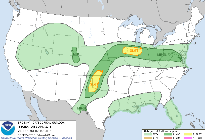
...THERE IS A SLIGHT RISK OF SEVERE THUNDERSTORMS FROM PARTS OF
SOUTHWESTERN KANSAS TO NORTHWEST TX...AND FROM EASTERN IOWA TO
NORTHWESTERN INDIANA....
...SUMMARY...
A few strong to severe thunderstorms are possible today from parts
of the Midwest to the Mid Atlantic, the southern/central Plains, and
a portion of the Colorado Front Range into the Laramie Mountains
vicinity of Wyoming. Damaging wind and hail will be the primary
threats.
...Synopsis...
A blocky, split-flow regime over western North America will continue
to dominate the upper-air pattern over the country today. A cut-off
cyclone centered over the Great Basin will continues to fill
gradually while drifting erratically near its present position. To
the east, ridging will prevail from the Ozarks to the Dakotas.
Farther downstream, a series of weak, substantially convectively
induced or enhanced perturbations will traverse a belt of west-
northwesterly flow from the Upper Midwest to the Mid-Atlantic and
New England. Meanwhile, another broad/cut-off cyclone, weaker than
the western low and presently situated over the eastern Gulf -- will
move slowly and erratically, with a probable net northward shift
over the northeastern Gulf through the period. This feature will
contribute to general thunderstorm potential over FL, as well as a
growing potential for heavy rain (per WPC precip-forecast products).
At the surface, 11Z analyses showed a wavy/quasistationary frontal
zone extending from a low over northeastern NM east-northeastward
over southern KS, central MO, central IN and southwestern PA,
intersecting a strong outflow boundary that extended southeastward
across northern VA to the southern Delmarva Peninsula near WAL. The
front may shift northward today over the lower Missouri Valley and
parts of IA, but elsewhere should remain near its present position,
with only minor/mesoscale movements. A dryline now over the
northern TX Panhandle and southeastern NM will mix eastward again
today, reaching the eastern Panhandle, southwestern KS, and the
Permian Basin region of west TX by mid/late afternoon.
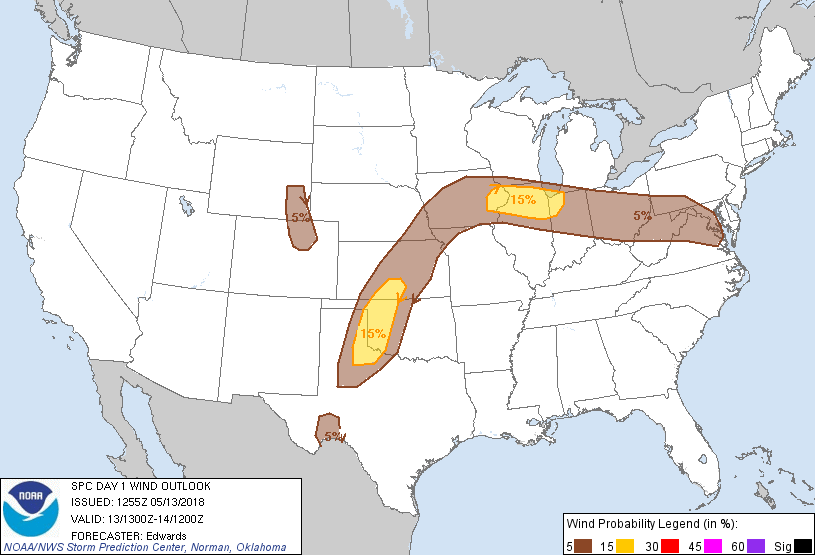
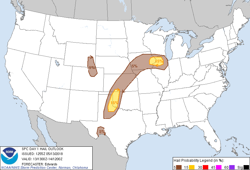
...Southern/central Plains...
Again today, afternoon thunderstorms are expected to initiate on and
very near the dryline, as related convergence and intense diabatic
heating overcome CINH in the basal EML capping layer. With greater
moisture and similarly steep midlevel lapse rates in place compared
to previous days, buoyancy will be much larger. MLCAPE is likely to
rise above 3000 J/kg within 50-75 nm east of the dryline, and some
values near 4000 J/kg are possible. Though strong directional shear
will exist in support of transient supercell characteristics,
vertical shear will be modest -- with effective-shear magnitudes
generally 25-35 kt and small 0-1-km hodographs. Multicells will be
the dominant storm mode for most of this event.
Regardless, the size, depth and "top-heavy" shape (e.g., 300-mb LI
of -13 to -16 C) of the buoyant profile in forecast soundings
suggest extremely intense updrafts, characterized by deep initial
lofting of condensate and fast-growing hydrometeors from a layer of
13-16 g/kg mean mixing ratios. In turn, that should yield the
potential for both severe downdrafts and large hail as cores
collapse. A few hours of upscale aggregation of multicellular
clusters and generally eastward forward propagation are possible,
extending the severe threat into parts of western OK, southwestern
KS and northwest TX. Activity should weaken with eastward extent
from there, as a combination of outflows and nocturnal/diabatic
cooling stabilize their inflow layers. The severe threat becomes
more isolated and conditional north and south of the "slight" risk
area due to coverage concerns, though a combination of modified
RAOBs, forecast soundings and a consensus of numerical guidance
suggest an afternoon severe thunderstorm or two may fire off the
dryline in the lower Pecos Valley region as well.
...Midwest...
A weak frontal-wave low may develop along the retreating boundary,
with theta-e advection occurring across the region. Boundary-layer
destabilization will be strong diurnally, both from that factor and
from diabatic surface heating, with MLCAPE and MUCAPE strengthening
into the 2000-3000 J/kg range. However, a stout elevated mixed
layer and mid/upper-level ridging over the region will render late-
afternoon severe potential very conditional. If thunderstorms storm
can sustain themselves in the relative convergence max near the low
over western/central IA, upscale development with eastward/forward-
propagating clustering and related severe-wind/hail potential may
occur earlier and somewhat farther west than presently indicated.
Barring that conditionality, and resultant stabilizing effects, low-
level warm advection, moisture transport and isentropic lift to LFC
are expected to support evening/overnight thunderstorm formation
mainly north of the boundary, offering a large-hail risk. This may
evolve to feature more of a wind threat with time, especially for
activity close to the frontal zone. Favorable mean winds, as well
as 40-50-kt effective-shear vectors -- each aligned nearly parallel
to the boundary -- may support a sustained severe threat into
tonight for any organized thunderstorm clusters that can develop.
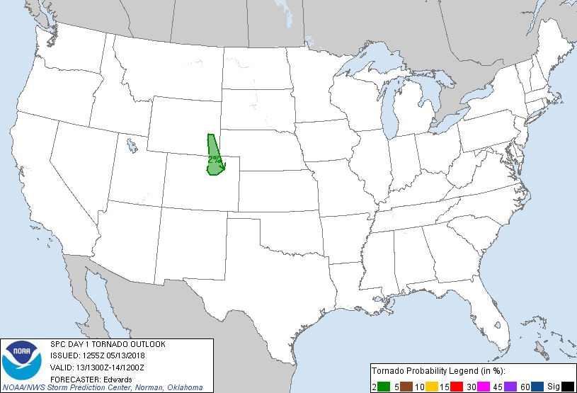
...Central Rockies region...
Widely scattered thunderstorms are expected to develop over portions
of the Front and Laramie Ranges late this afternoon, offering
isolated large hail and damaging gusts. A tornado cannot be ruled
out, with that threat strongly dependent upon meso-gamma to
storm-scale processes. A narrow corridor of favorable
destabilization will occur over the mountains, foothills, and a
small part of the adjacent High Plains, primarily within and north
of a cyclonically curved convergence zone forming over the DEN area.
Slightly rising heights aloft (with a lack of substantial upper
perturbations) and the presence of a strong EML will hamper
convection through most of the day; however, persistence of heating
and upslope flow should be sufficient for storms to develop by late
afternoon.
Forecast soundings show 800-1200 J/kg MLCAPE for a few hours around
00Z in the northern lobe of the convergence zone, and in a narrow
tongue northward toward the Laramie Range. The easterly surface
flow component north of the convergence zone will contribute upslope
lift, favorable storm-relative boundary-layer winds, augmented deep
shear with 40-50 kt effective-shear magnitudes, and locally
elongated 0-3-km hodographs to support supercell potential.
However, such flow also will advect more stable, smaller-theta-e air
from lower elevations, and keep the spatiotemporal window for
optimally productive storm maturity rather narrow. For now the
threat remains too small-scale and conditional for an upgrade, but
one may be needed should it become better-defined and more focused
through the day.
...Central Appalachians to Middle Atlantic region...
Scattered thunderstorms in episodic clusters are expected along and
north of the front and outflow boundary through the period, offering
isolated hail and possibly damaging gusts. Any activity accessing
effectively surface-based inflow parcels along and south of the
front would have a less-conditional damaging-wind threat, though
coverage may be lower in the warm sector, with deep shear decreasing
southward.
The outflow pool behind the boundary has been reinforced by
overnight precip, as well as additional/ongoing clusters of showers
and thunderstorms over southwestern/south-central PA, the eastern
panhandle of WV, and northern VA. This will hinder airmass recovery
across northern VA into south-central PA today. Progs are
accordingly inconsistent on the progress of the warm sector back
into those areas, with more confidence in destabilization over
southwestern PA. To the extent the boundary can retreat back under
the southern rim of the stronger mid/upper level winds, and in
combination with vorticity along the retreating boundary, a
narrow/localized supercell threat may develop. However, mesoscale
conditionalities and uncertainties preclude greater than
marginal-level unconditional outlook probabilities at this time.
..Edwards/Mosier.. 05/13/2018
CLICK TO GET WUUS01 PTSDY1 PRODUCT
NOTE: THE NEXT DAY 1 OUTLOOK IS SCHEDULED BY 1630Z
|