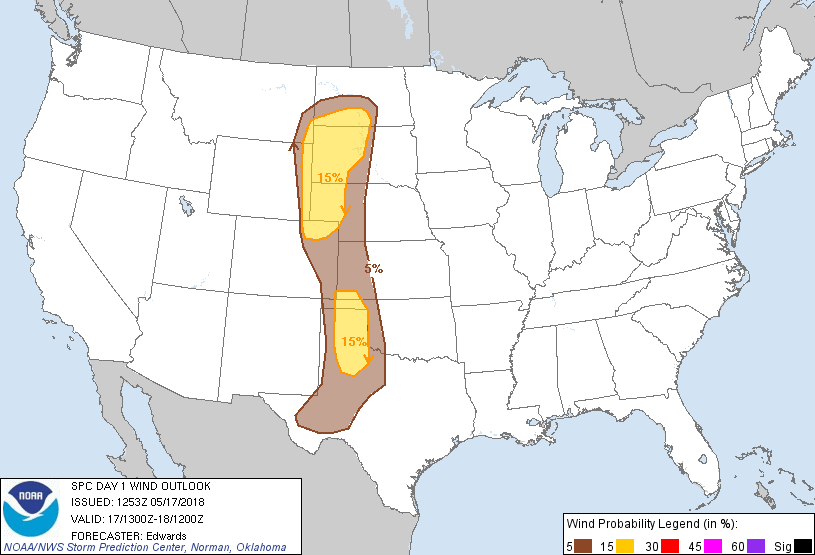
Probability of damaging thunderstorm winds or wind gusts of 50 knots or higher within 25 miles of a point. Hatched Area: 10% of greater probability of wind gusts 65 knots or greater within 25 miles of a point.
Day 1 Wind Risk
Area (sq. mi.)
Area Pop.
Some Larger Population Centers in Risk Area
15 %
112,761
1,044,365
Amarillo, TX...Rapid City, SD...Bismarck, ND...Plainview, TX...Liberal, KS...
SPC AC 171253
Day 1 Convective Outlook
NWS Storm Prediction Center Norman OK
0753 AM CDT Thu May 17 2018
Valid 171300Z - 181200Z
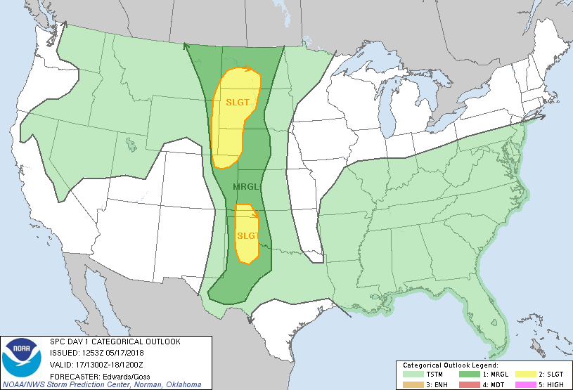
...THERE IS A SLIGHT RISK OF SEVERE THUNDERSTORMS OVER PARTS OF THE
HIGH PLAINS BETWEEN NORTH DAKOTA AND NORTHWEST TEXAS...
...SUMMARY...
Severe storms are expected this afternoon and evening across
portions of the High Plains.
...Synopsis...
The upper-air pattern is characterized by troughing over the West,
and also east of the Mississippi River, with weak ridging over the
High Plains. That ridging is forecast to shift eastward gradually
through the period, as the western trough (with primary vorticity
max and small 500-mb cyclone initially over western NV) moves
eastward to UT and AZ. Several lower-amplitude/precursory
shortwaves will eject through the downstream southwesterly flow
field, including a perturbation now apparent in moisture-channel
imagery over eastern UT. This feature should reach eastern WY by
00Z, with considerable strengthening due to convective vorticity
augmentation thereafter. By 12Z, the trough should be located over
the central Dakotas and northern NE, perhaps with one or two
embedded MCVs. Meanwhile, east of the ridge, a binary
mid/upper-level cyclone is evident with centers near MKC and over
northeastern AR. The southern lobe -- primarily related to an MCV
-- should move southeastward with gradual weakening, while the
northern one moves slowly southeastward across MO.
At the surface, 11Z analysis shows an Arctic cold front from
northern New England across southern ON, southern Lake Michigan, and
southern WI, becoming quasistationary west-northwestward to a low
between 2WX and DIK, to another weak low near GGW, then extending
over southern AB. This front should proceed southward/southeastward
across the remainder of New England and parts of the Mid-Atlantic
and portions of IL/IN/IA through the period, while the area of low
pressure shifts eastward slowly across southern ND. Temporarily
shunted southward into northwestern SD by ongoing convection, the
baroclinic zone should retreat to near or just north of the ND/SD
line by late afternoon.
A dryline and nearly collocated lee trough should remain largely in
place, save for minor/mesoscale oscillations due to mixing and
outflows, from the northern Plains low-pressure area southward
across eastern CO. Some eastward motion is likely into the TX
Panhandle and South Plains/Permian Basin regions, due to relatively
intense heating/mixing. A secondary area of low pressure should
develop over eastern CO this afternoon. Otherwise, a broad,
diffuse, slowly weakening, quasistationary frontal zone was analyzed
from central/southwest TX across TN to the Delmarva region. Little
movement is expected with this feature today.
...Great Plains...
Scattered thunderstorms are expected to develop across the High
Plains in generally north-south corridors, near the dryline/lee
trough. Greatest potential convective concentration still appears
to be over parts of the southern High Plains, where strong heating
and relatively maximized theta-e is expected, and from northeastern
CO to the western Dakotas near and south of the Arctic front --
though isolated activity is possible in between and on either side.
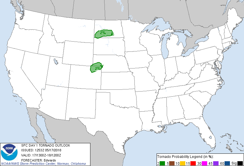
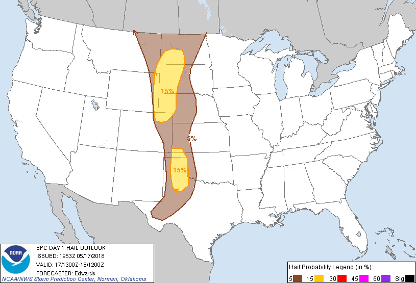
The main concerns will be damaging gusts and large hail, though a
tornado or two cannot be ruled out where favorable storm/boundary
interactions may occur.
Buoyancy should increase throughout the day along and east of the
dryline/lee trough, as a combination of strong diabatic surface
heating and moisture advection/transport occur. Surface dew points
generally should be in the 50s F over the central/northern Plains
moist sector, and in the 50s to low 60s over the southern Plains,
where considerable variability may occur due to vertical mixing
within residual pockets of outflow air. Steep midlevel lapse rates,
associated with a well-developed EML, will spread over that moist
sector, leading to a narrow corridor of favorable buoyancy, peaking
over the southern Plains slight-risk area where surface heating will
be most intense. In that area, 2000-3000 J/kg MLCAPE is possible.
Given its higher boundary-layer theta-e and the presence of some
favorable cloud-layer shear beneath the northern rim of a
subtropical jet, relatively organized multicells and perhaps
transient supercells are possible with the southern Plains activity.
However, weak midlevel winds are expected, and storms should
aggregate upscale relatively quickly.
Farther north, some at least short-lived supercell potential is
possible over portions of northeastern CO/southern NE Panhandle
region where backed near-surface flow north of the lee low enhances
hodographs, and near an area of backed flow and vorticity
enhancement related to the frontal zone and low-pressure area in ND.
A plume of large-scale ascent preceding the ejecting shortwave
trough may support some relatively dense convective coverage and
cold-pool aggregation over the northern Plains outlook area as well,
south of the frontal zone.
...Southeastern States...
Scattered thunderstorms are expected to develop this afternoon over
a large area from MO eastward to VA/MD (near and south of a
residual/weak frontal zone), and southward to southeastern MS and
portions of the FL Peninsula. Activity will be aided by areas of
strong diabatic heating of a generally richly moist but also
well-mixed boundary layer, weak MLCINH, sea-breeze boundaries near
the coasts, outflows across the region, and an area of ascent near
and southeast of the Ozarks/Mid-South perturbation. Some convection
associated with the latter is evident over western MS into
northeastern AR and southern MO at this time.
Within this broad area, isolated wet downbursts approaching severe
limits and capable of minor damage are possible, and a few clusters
may aggregate with well-developed mesobeta-scale cold pools. At
this time, the risk appears too isolated and/or dependent on
uncertain localized boundary evolutions for an unconditional/
categorical severe area, though mesoscale trends will be monitored
for potential concentrations of more than localized/brief wind
events.
..Edwards/Goss.. 05/17/2018
CLICK TO GET WUUS01 PTSDY1 PRODUCT
NOTE: THE NEXT DAY 1 OUTLOOK IS SCHEDULED BY 1630Z