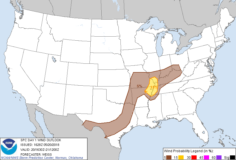
San Antonio, TX...Austin, TX...St. Louis, MO...Cincinnati, OH...Louisville, KY...
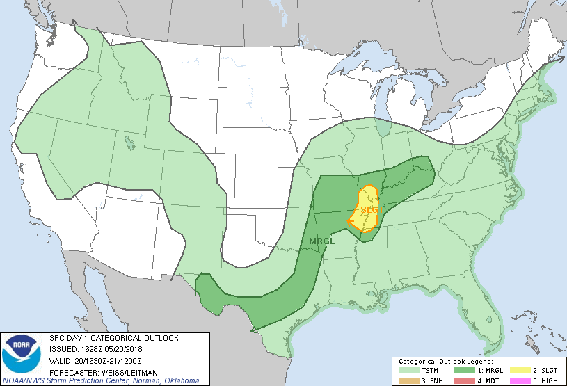
Probabilistic Tornado Graphic
Probability of a tornado within 25 miles of a point. Hatched Area: 10% or greater probability of EF2 - EF5 tornadoes within 25 miles of a point.
Day 1 Tornado Risk
Area (sq. mi.)
Area Pop.
Some Larger Population Centers in Risk Area
2 %
20,450
68,684
Carlsbad, NM...Pecos, TX...
Probabilistic Damaging Wind Graphic
Probability of damaging thunderstorm winds or wind gusts of 50 knots or higher within 25 miles of a point. Hatched Area: 10% of greater probability of wind gusts 65 knots or greater within 25 miles of a point.
San Antonio, TX...Austin, TX...St. Louis, MO...Springfield, MO...Mesquite, TX...
   SPC AC 201628

   Day 1 Convective Outlook
   NWS Storm Prediction Center Norman OK
   1128 AM CDT Sun May 20 2018

   Valid 201630Z - 211200Z

   ...THERE IS A SLIGHT RISK OF SEVERE THUNDERSTORMS FROM THE
   MID-MISSISSIPPI VALLEY INTO THE MID-SOUTH...

   ...SUMMARY...
   Strong to severe storms are possible across a large area from parts
   of southern and eastern Texas into the Ozarks and eastward into the
   Ohio Valley.  A more focused area of severe threat is expected from
   southern Illinois and southeast Missouri into northeast Arkansas and
   west Tennessee.

   ...Mid Mississippi Valley into the Mid-South...
   Several low-level convective boundaries are analyzed extending from
   southwest Indiana across far southeast Missouri, with an additional
   boundary arcing southward from ongoing convection over east central
   Missouri then extending westward across northern Arkansas.  The
   latter boundary is moving southeastward across southeast Missouri
   into a very moist low-level air mass where surface dewpoints are in
   the upper 60s to lower 70s.  Moderately steep mid-level lapse rates
   sampled by the 12Z LZK sounding extend into the Mid-South and are
   contributing to MLCAPE of 1500-2500 J/kg.  The area is along the
   southern edge of stronger westerly mid-level winds which may aid in
   storm organization with primarily multicell storms likely this
   afternoon.

   Model guidance including 12Z CAMs/HREF indicate storms will increase
   in coverage this afternoon as continued heating weakens the cap and
   convergence is focused along the primary outflow boundary.  The
   strong thermodynamic support suggest a few storms will become severe
   capable of producing large hail and strong wind gusts.  Activity
   will continue into the evening before storms begin to diminish by
   01-03z.

   ...Parts of eastern Oklahoma into western Arkansas and southwest
   Missouri...
   Visible imagery indicates clouds have thinned over this area in
   advance of a mid-level short-wave trough lifting northeastward from
   the Plains toward the lower Missouri Valley.  This will promote air
   mass destabilization in the wake of overnight convection.  Model
   guidance indicates a few storms will redevelop this afternoon from
   eastern Oklahoma into southwest Missouri along/immediately ahead of
   an advancing cold front and/or convective outflow.  Although winds
   aloft may slowly weaken into tonight, sufficient vertical shear may
   persist to aid development of a few strong to severe storms this
   afternoon and evening.  A Marginal Risk has been added across parts
   of this area.

   ...Southern into Eastern Texas...
   An extensive band of convection is moving southward/southeastward
   extending from east of the DFW Metroplex into central Texas.  The
   air mass across the region in advance of the convection remains
   moist and unstable with MLCAPE of 1500-2500 J/kg expected this
   afternoon.  The convection is likely to continue this afternoon with
   a few strong to severe storms possible.  Overall severe threat will
   be limited by marginal vertical shear, but stronger cells will be
   capable of producing hail and strong wind gusts.

   Other strong to isolated severe storms are expected to develop this
   afternoon within the moist upslope low-level flow over southwest
   Texas.

   ...Ohio Valley...
   A few strong storms will be possible this afternoon and evening over
   parts of the Ohio Valley near and south of a frontal boundary
   extending from southern Indiana into southern Ohio.  Forcing for
   large scale ascent appears to be weak which may limit the coverage
   of storms.

   ..Weiss/Leitman.. 05/20/2018

   CLICK TO GET WUUS01 PTSDY1 PRODUCT

   NOTE: THE NEXT DAY 1 OUTLOOK IS SCHEDULED BY 2000Z