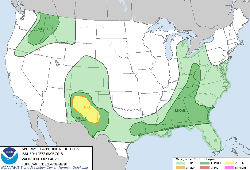
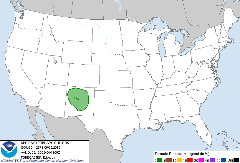
Probability of a tornado within 25 miles of a point. Hatched Area: 10% or greater probability of EF2 - EF5 tornadoes within 25 miles of a point.
Day 1 Tornado Risk
Area (sq. mi.)
Area Pop.
Some Larger Population Centers in Risk Area
2 %
52,698
1,314,233
Albuquerque, NM...Santa Fe, NM...Rio Rancho, NM...South Valley, NM...Alamogordo, NM...
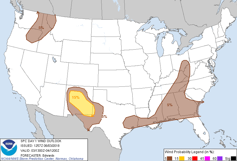
Probabilistic Damaging Wind Graphic
Probability of damaging thunderstorm winds or wind gusts of 50 knots or higher within 25 miles of a point. Hatched Area: 10% of greater probability of wind gusts 65 knots or greater within 25 miles of a point.
Day 1 Wind Risk
Area (sq. mi.)
Area Pop.
Some Larger Population Centers in Risk Area
15 %
59,278
1,433,348
Albuquerque, NM...Santa Fe, NM...Rio Rancho, NM...Roswell, NM...South Valley, NM...
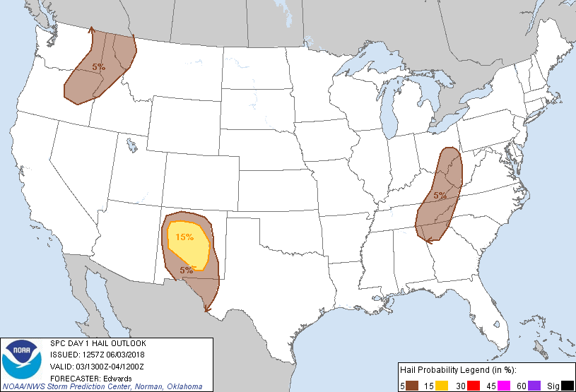
Probability of hail 1" or larger within 25 miles of a point. Hatched Area: 10% or greater probability of hail 2" or larger within 25 miles of a point.
Day 1 Hail Risk
Area (sq. mi.)
Area Pop.
Some Larger Population Centers in Risk Area
15 %
38,883
1,247,500
Albuquerque, NM...Santa Fe, NM...Rio Rancho, NM...South Valley, NM...Alamogordo, NM...
5 %
201,488
12,123,672
Spokane, WA...Knoxville, TN...Chattanooga, TN...Sandy Springs, GA...Las Cruces, NM...
   SPC AC 031257

   Day 1 Convective Outlook
   NWS Storm Prediction Center Norman OK
   0757 AM CDT Sun Jun 03 2018

   Valid 031300Z - 041200Z

   ...THERE IS A SLIGHT RISK OF SEVERE THUNDERSTORMS OVER MUCH OF NEW
   MEXICO AND ADJOINING PORTIONS OF WEST TEXAS...

   ...SUMMARY...
   The greatest potential for severe thunderstorms, with large hail and
   wind damage the main threats, is this afternoon and evening across
   parts of New Mexico.

   ...Synopsis...
   In mid/upper levels, a progressive pattern will continue over much
   of the contiguous U.S., except for the anticyclone anchored across
   portions of northern MX and the Big Bend region of west TX.  Mean
   ridging that extends north-northwestward, up the Rockies into
   Canada, will be penetrated by a well-developed shortwave trough now
   evident in moisture-channel imagery over AZ and southern UT.  This
   trough should eject east-northeastward to the southern Rockies,
   extending from south-central CO to near ELP by 00Z.  By 12Z, the
   trough (with some convective vorticity supplementation likely)
   should extend from the central High Plains southward across the
   OK/TX Panhandles to the TX South Plains region.

   East of the mean ridge, a strong synoptic trough will extend
   southeastward from a weakening 500-mb cyclone over northern SK,
   through an intensifying low crossing Lake Superior and adjoining
   northern ON.  The southward extension of the trough will cross the
   upper Great Lakes today and reach inland NY and PA by the end of the
   period.  Meanwhile, as a cyclone moves slowly eastward toward
   northern parts of the BC coast, a series of shortwaves will eject
   northeastward from its basal synoptic trough across the northwestern
   U.S.  The strongest of those -- now evident west of WA/OR around
   137W -- will move ashore around 00Z.  This perturbation then should
   deamplify and eject northeastward across the Canadian Rockies late
   overnight.

   At the surface, 11Z analysis showed a cold front, extending from an
   occlusion triple point over eastern IN southwestward across AR and
   central TX to south-central and northwestern NM.  By 00Z, this front
   should reach western NC, central AL, central LA, and southwest TX,
   becoming quasistationary northwestward across southern and
   northwestern NM.  By 12Z the front should reach eastern NC, the
   LA/MS Gulf coast, and south-central TX, becoming ill-defined amidst
   more intensively baroclinic convective outflow processes over NM and
   portions of west TX.

   ...NM, west TX...
   Scattered thunderstorms are forecast to develop, initially in two
   somewhat separate regimes that may merge over central NM as they
   evolve upscale;

   1. Midday or even midmorning through afternoon over northwestern
   into west-central NM.  A narrower favorable thermodynamic sector
   here under colder air and stronger large-scale forcing aloft will
   render the threat somewhat earlier and perhaps shorter-lived
   compared to farther southeast.  Supercells and merging lines of
   convection are expected, with all severe types possible.
   2.  Afternoon and evening, with storm initiation on higher terrain
   either side of the Rio Grande Valley and southward over Chihuahua.
   Early high-based supercell and multicell modes should offer
   wind/hail threats before potentially evolving upscale into an
   evening/overnight MCS activity that will offer mainly a wind threat.
    Strong consensus in available synoptic and CAM guidance for this
   scenario compels an enlargement of wind probabilities over portions
   of southern NM and west TX.

   In both regimes, a net easterly flow component in and north of the
   frontal zone will aid storm development, longevity and severity
   today through mass convergence, greater deep shear, enlarged
   low-level shear/hodographs, stronger storm-relative flow in low
   levels, upslope flow on eastern faces of ranges, and moisture
   advection.  A roughly northwest/southeast-oriented axis of favorable
   moisture should take shape across NM, with surface dew points 40s to
   low 50s and 1.0-1.4-inch PW, amidst strengthening heating with
   southward extent.  A corridor of preconvective MLCAPE roughly
   1000-1500 J/kg should develop, narrowing from southern into western
   NM.

   In addition to the backed near-surface winds, a tightening mid/upper
   height gradient and related enhancements to winds aloft will
   contribute further to favorable shear.  Forecast soundings
   reasonably depict 45-55-kt effective shear and affective SRH 200-400
   J/kg in the narrow CAPE plume over west-central/northwestern NM,
   favoring relatively lowered LCL and the potential for supercells and
   even a tornado or two as long as storms can remain discrete within
   surface-based buoyancy.  Meanwhile, hotter diurnal surface
   conditions, higher LCL, and more deeply mixed boundary layers are
   likely over southern NM and west TX, persisting into evening even as
   a strengthening, confluent LLJ develops into the region to aid
   storm-relative/inflow-wind vectors.

   ...Ohio Valley to Southeast...
   Widely scattered to scattered thunderstorms are forecast to develop
   this afternoon as diurnal heating minimizes MLCINH near the cold
   front, and along prefrontal boundaries such as outflows, sea breezes
   and differential-heating zones.  Isolated damaging gusts are
   possible, and marginally severe hail cannot be ruled out.

   The favorable prefrontal sector will narrow with northward extent
   ahead of the front, exhibiting 500-1500 J/kg MLCAPE and largely
   unidirectional vertical wind profiles from the OH Valley through TN,
   with MLCAPE increasing to the 2000-3000 J/kg range across portions
   of AL and 3000-4000 J/kg over southeast TX, west of a residual plume
   of clouds/precip over portions of LA.  Slight strengthening of
   deep-layer speed shear with northward extent will be offset somewhat
   by increasing buoyancy southward and westward (away from area of
   antecedent clouds/precip).  Hodographs should remain relatively
   small in low levels.

   Especially over parts of the Southeast, mesoscale concentrations of
   wind-damage potential may develop under and downshear from where
   clusters of convection can form in response to strong diurnal
   heating, rich low-level moisture, and processes/interactions of
   various boundaries.  Given the mesoscale to storm-scale (i.e.,
   cold-pool process) dependencies, will leave the broad-brushed 5% for
   now, subject to more-focused upgrading as boundary/convective trends
   warrant.

   ...Interior Northwest/northern Rockies...
   Widely scattered to scattered thunderstorms should develop this
   afternoon into evening, initially over eastern OR, and move rapidly
   northeastward across the outlook area into this evening, offering
   the potential for isolated damaging wind and marginally severe hail.
   Lower-elevation surface dew points generally in the 40s F and steep
   low/middle-level lapse rates -- the latter including very well-mixed
   boundary layers -- will support the development of MLCAPE to around
   500 J/kg in the preconvective environment.  Strong mid/upper-level
   flow will contribute to deep-layer speed shear and 30-40 kt
   effective shear magnitudes.  Limiting factors will include lack of
   both more robust buoyancy and low-level shear.

   ..Edwards/Marsh.. 06/03/2018

   CLICK TO GET WUUS01 PTSDY1 PRODUCT

   NOTE: THE NEXT DAY 1 OUTLOOK IS SCHEDULED BY 1630Z