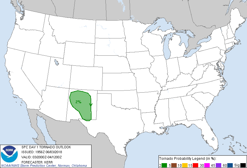
Probability of a tornado within 25 miles of a point. Hatched Area: 10% or greater probability of EF2 - EF5 tornadoes within 25 miles of a point.
Day 1 Tornado Risk
Area (sq. mi.)
Area Pop.
Some Larger Population Centers in Risk Area
2 %
63,136
1,439,755
Albuquerque, NM...Santa Fe, NM...Rio Rancho, NM...Roswell, NM...South Valley, NM...
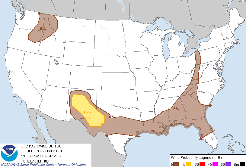
Probabilistic Damaging Wind Graphic
Probability of damaging thunderstorm winds or wind gusts of 50 knots or higher within 25 miles of a point. Hatched Area: 10% of greater probability of wind gusts 65 knots or greater within 25 miles of a point.
SPC AC 031956
Day 1 Convective Outlook
NWS Storm Prediction Center Norman OK
0256 PM CDT Sun Jun 03 2018
Valid 032000Z - 041200Z
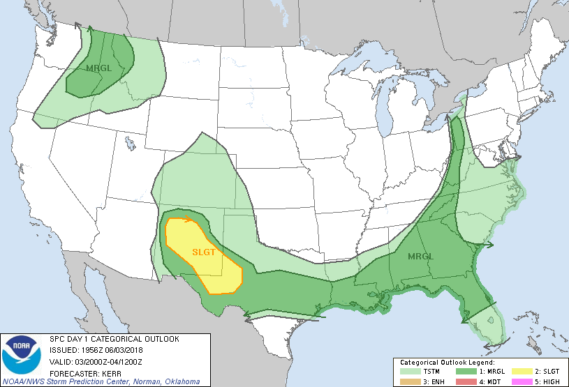
...THERE IS A SLIGHT RISK OF SEVERE THUNDERSTORMS LATE THIS
AFTERNOON AND EVENING ACROSS NEW MEXICO INTO WESTERN/SOUTHWEST
TEXAS...
...SUMMARY...
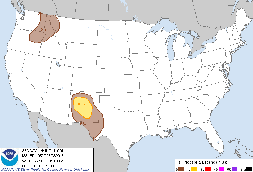
The greatest potential for severe thunderstorms, with large hail and
wind damage the main threats, is this afternoon and evening across
parts of New Mexico into west/southwest Texas. Other more isolated
severe thunderstorms are possible across the Gulf Coast States and
near the Appalachians as well as the northern Rockies.
...20Z Outlook Update...
Some changes to categorical and probabilistic lines have been made
to account for current trends concerning destabilization and
ongoing/prior convective development.
...Southern Rockies/west Texas vicinity...
Stronger destabilization has been largely focused across the higher
terrain west of the Rio Grande River in New Mexico, and along the
southwestern slopes of the Davis Mountains vicinity of far southwest
Texas. However, moistening upslope flow along the
northeastern/eastern slopes of the Davis Mountains into the
Guadalupe and Sacramento Mountains is forecast to contribute to
moderately large boundary layer CAPE by early evening. This should
support increasing convective development along the higher terrain.
In the presence of light (less than 20 kt) southwesterly mean flow,
activity may be slow to propagate off the higher terrain, but
strong deep layer shear due to pronounced veering of winds with
height may support organizing convective development (including
supercells initially) which may eventually propagate into the Pecos
Valley this evening.
Otherwise, scattered severe storms, including isolated supercells,
likely will continue through the remainder of the afternoon across
the Rio Grande vicinity of New Mexico.
...Ahead of front from eastern Texas into southern Appalachians...
Daytime heating beneath a remnant plume of steep lapse rates
associated with elevated mixed layer air has contributed to large
CAPE and thermodynamic profiles at least conditionally conducive to
storms capable of producing localized downbursts and strong cold
pools with potential for severe surface gusts. While widely
scattered thunderstorm development is underway, weak low-level
shear and convergence along and ahead of the front still seem likely
to limit the overall severe weather threat, at least in terms of
coverage. Stronger lingering mid-level inhibition across/west of
the lower Mississippi Valley vicinity also is expected to suppress
the overall convective potential.
..Kerr.. 06/03/2018
.PREV DISCUSSION... /ISSUED 1159 AM CDT Sun Jun 03 2018/
...New Mexico into west/southwest Texas...
A shortwave trough will continue to spread northeastward over the
southern Rockies and reach the south-central High Plains late
tonight. Some thunderstorms are already occurring this morning
across northern into central New Mexico. A very moist air mass for
the region and gradual heating/destabilization this afternoon will
allow for additional development over interior/west-central New
Mexico, and by late afternoon across south-central New Mexico/nearby
Mexico into far west Texas. Strong vertical shear (40+ kt effective
shear) will support some supercells capable of large hail, some
severe-caliber wind gusts, and perhaps even a tornado. It still
appears plausible, if not likely, that storms will merge and grow
upscale and spread generally eastward into west/southwest Texas
during the evening into the overnight with the possibility of a
continued damaging wind risk along with some hail.
...Gulf Coast/Southeast States...
Isolated severe storms capable of wind damage and some hail are
expected this afternoon and early evening across the region. A very
moist air mass exists across the region in advance of a
south/southeastward-moving cold front, with an elevated mixed
layer/steep mid-level lapse rates noted along the Gulf Coast into
Georgia as noted per 12Z observed soundings (7+ C/km 700-500 lapse
rates noted as far northeast as Atlanta/FFC). Although larger scale
forcing will be weak on the periphery of the southern tier upper
ridge, the front, and perhaps more so, some residual/subtle outflows
and zones of differential heating will influence isolated to widely
scattered thunderstorm development within a destabilizing air mass.
A few south/southeastward-moving clusters of storms may evolve
across the region this afternoon with wind damage and some hail
possible.
...Upper Ohio Valley/Appalachians vicinity...
Isolated severe storms capable of wind damage and possibly some hail
are expected this afternoon across the region. Although mid-level
lapse rates will not be steep, a relatively moist air mass (60s F
surface dewpoints) and ample insolation/heating will occur across
the upper Ohio River Valley and nearby Appalachians in advance of an
eastward-moving cold front. Aided by the glancing influence of a
shortwave trough over the Great Lakes, storms should increase and
intensify this afternoon as low-level lapse rates steepen, with such
development initially spanning eastern portions of Ohio, Kentucky,
and Tennessee. At least isolated instances of wind damage and some
hail are expected as storms spread eastward through the afternoon
into evening.
...Interior Northwest/northern Rockies...
Widely scattered to scattered thunderstorms should develop this
afternoon into evening, initially over eastern Oregon, and move
rapidly northeastward across the outlook area into this evening,
offering the potential for isolated damaging wind and marginally
severe hail. Lower-elevation surface dew points generally in the 40s
F and steep low/middle-level lapse rates -- the latter including
very well-mixed boundary layers -- will support the development of
MLCAPE to around 500 J/kg in the preconvective environment. Strong
mid/upper-level flow will contribute to deep-layer speed shear and
30-40 kt effective shear magnitudes. Limiting factors will include
lack of both more robust buoyancy and low-level shear.
CLICK TO GET WUUS01 PTSDY1 PRODUCT
NOTE: THE NEXT DAY 1 OUTLOOK IS SCHEDULED BY 0100Z