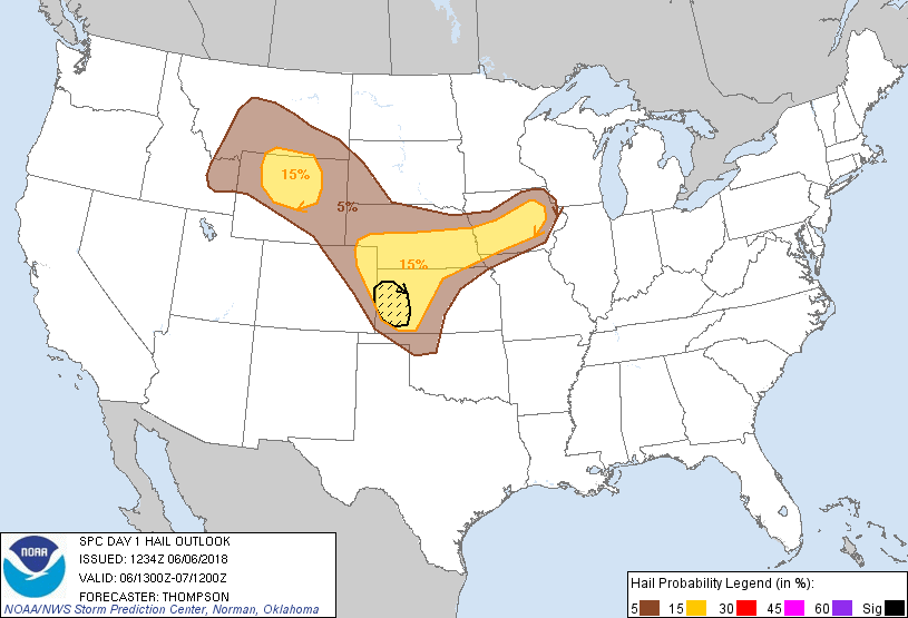
Probability of damaging thunderstorm winds or wind gusts of 50 knots or higher within 25 miles of a point. Hatched Area: 10% of greater probability of wind gusts 65 knots or greater within 25 miles of a point.
Fort Collins, CO...Billings, MT...Greeley, CO...Sioux City, IA...Iowa City, IA...
SPC AC 061234
Day 1 Convective Outlook
NWS Storm Prediction Center Norman OK
0734 AM CDT Wed Jun 06 2018
Valid 061300Z - 071200Z
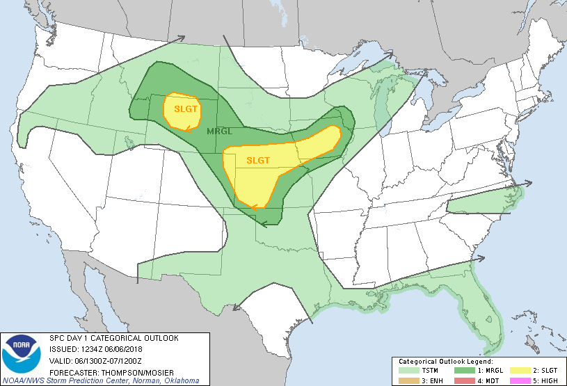
...THERE IS A SLIGHT RISK OF SEVERE THUNDERSTORMS MAINLY THIS
AFTERNOON AND EVENING FROM CENTRAL IA TO WESTERN KS...AND ACROSS
CENTRAL AND NORTH CENTRAL WY...
...SUMMARY...
Thunderstorms will be capable of producing large hail and damaging
winds in several corridors later today into early tonight across
western Kansas and vicinity, Iowa, and Wyoming.
...Southwestern NE to northwestern OK late this afternoon through
early tonight...
Strong surface heating/mixing along the west edge of the richer
low-level moisture and low-level upslope flow will support
thunderstorm development late this afternoon/evening from eastern CO
into western KS and southwest NE. An MCS should emerge from this
initial activity and propagate eastward along and just south the
slow-moving front in NE and northwest KS. Some large hail will be
possible, though damaging outflow winds will become the main threat
as a result of steep low-level lapse rates/strong downdraft
potential and large buoyancy. A separate MCS corridor will be
possible from western KS southeastward toward northwest OK late this
evening into early tonight. Here, initial high-based convection
near the CO/KS border will encounter increasingly large buoyancy
(MLCAPE of 3000-4000 J/kg) while spreading into western KS. Some
supercell structures will be possible initially given the large
CAPE/steep lapse rate environment with effective bulk shear of
35-40kt. The storms should then grow upscale through
mergers/outflow interactions and then forward propagate into the
strengthening low-level southeasterly/southerly flow this evening
along the corridor of strong buoyancy. The storms could make it as
far southeast as northwestern OK before the damaging wind/hail
threats begin to diminish overnight. Will add significant severe
areas for hail given some supercell potential and large CAPE/steep
lapse rates, as well as for damaging winds given intense downdraft
potential in the hybrid profiles with large CAPE atop a deeply mixed
boundary layer, though uncertainties remain regarding storm coverage
and evolution.
...IA to eastern NE through this evening...
An MCS (with a well-defined MCV and cold pool) is moving
southeastward across southern MN this morning, along a surface warm
front and the instability gradient. The outflow with this
convection is well ahead of the somewhat diffuse synoptic cold
front. The convection has been weakening this morning and the
outflow is expected to slow across central IA by midday. Surface
heating along the outflow boundary and south of the remnant MCS
cloud shield, and a continued influx of 68+ F dewpoints from
KS/southeast NE, will drive strong buoyancy this afternoon.
Additional thunderstorms should form mid-late afternoon across
central IA along the remnant outflow, and subsequently move
southward and develop westward toward eastern NE. Deep-layer
vertical shear will be sufficient for a mix of organized multicell
clusters and/or marginal supercells, with an attendant threat for
large hail and damaging winds.
...Central and northern WY this afternoon/evening...
Water vapor imagery shows a midlevel shortwave trough moving
north-northeastward toward southwestern UT this morning. This
trough will approach western WY this evening and interact with the
west edge of relatively rich low-level moisture (55-60 F dewpoints
now across central WY), within the upslope flow regime north of a
slow-moving cold front. Thunderstorm development is expected over
the high terrain of the Wind River and Absaroka ranges by around mid
afternoon, and storms will then spread northeastward toward the Big
Horn Basin. Moderate buoyancy (MLCAPE of 1500-2500 J/kg) and
effective bulk shear of 30-40kt will be sufficient for supercells,
though growth into a larger cluster is also expected this
afternoon/evening. Large hail will be possible with any initial
supercells, with the threat transitioning more to damaging winds as
upscale growth occurs.
..Thompson/Mosier.. 06/06/2018
CLICK TO GET WUUS01 PTSDY1 PRODUCT
NOTE: THE NEXT DAY 1 OUTLOOK IS SCHEDULED BY 1630Z