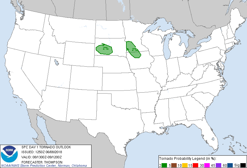
Probability of a tornado within 25 miles of a point. Hatched Area: 10% or greater probability of EF2 - EF5 tornadoes within 25 miles of a point.
Day 1 Tornado Risk
Area (sq. mi.)
Area Pop.
Some Larger Population Centers in Risk Area
2 %
36,589
610,111
Rapid City, SD...Fort Dodge, IA...Ledyard, IA...Pierre, SD...New Ulm, MN...
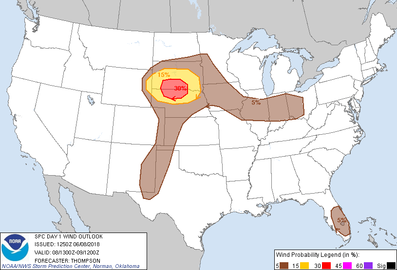
Probabilistic Damaging Wind Graphic
Probability of damaging thunderstorm winds or wind gusts of 50 knots or higher within 25 miles of a point. Hatched Area: 10% of greater probability of wind gusts 65 knots or greater within 25 miles of a point.
Day 1 Wind Risk
Area (sq. mi.)
Area Pop.
Some Larger Population Centers in Risk Area
30 %
23,739
67,328
No Major Population Center in Risk Area
15 %
60,344
457,358
Rapid City, SD...Mitchell, SD...Pierre, SD...Yankton, SD...Huron, SD...
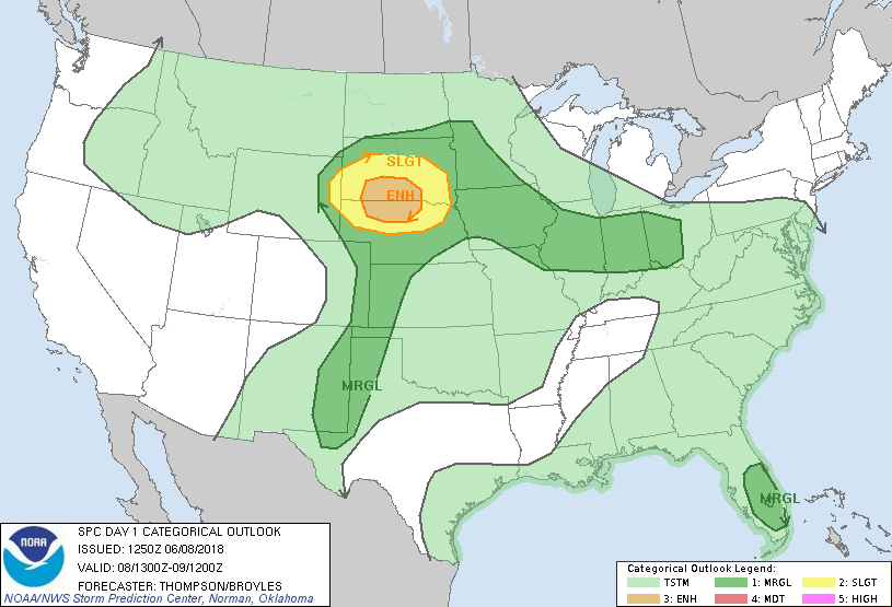
   SPC AC 081250

   Day 1 Convective Outlook
   NWS Storm Prediction Center Norman OK
   0750 AM CDT Fri Jun 08 2018

   Valid 081300Z - 091200Z

   ...THERE IS AN ENHANCED RISK OF SEVERE THUNDERSTORMS THIS AFTERNOON
   INTO EARLY TONIGHT FOR SOUTHERN SD AND NORTHERN NE...

   ...SUMMARY...
   Severe hail and wind is likely across parts of the northern Plains
   during the late afternoon and evening. Sporadic hail or wind is also
   possible across the central and southern High Plains, over parts of
   the Midwest, and over central Florida.

   ...SD/NE this afternoon into tonight...
   The remnants of a small overnight MCS will continue to move eastward
   from eastern SD to southern MN/northwestern IA today, along with an
   attendant MCV.  As a result of rain-cooled outflow, a baroclinic
   zone has become diffuse this morning.  Still, surface heating will
   result in destabilization in the wake of the overnight convection,
   and will help re-establish the baroclinic zone across SD by this
   afternoon.  Strong buoyancy is expected along and south of the
   boundary (MLCAPE in excess of 3000 J/kg) as a surface temperatures
   warm to 85-90 F, with boundary-layer dewpoints in the mid 60s
   beneath steep midlevel lapse rates.  Initial thunderstorm
   development is expected in the weak upslope flow regime across the
   Black Hills by mid afternoon, to the north of a weak lee cyclone
   across the central High Plains.  Vertical shear will be marginally
   supportive of supercells initially, with some threat for isolated
   very large hail.  With the approach of a subtle midlevel trough from
   WY/MT this afternoon, storms should grow upscale through mergers and
   outflow interactions and spread eastward and southeastward across
   SD/northern NE through tonight.  The steep lapse rate environment
   will favor strong downdrafts with damaging winds this evening, in
   addition to a continuing large hail threat.

   ...Central and southern High Plains this afternoon/evening...
   Low-level moisture has spread westward into eastern NM, on the west
   side of outflow from overnight storm clusters in TX.  Strong surface
   heating will contribute to scattered high-based thunderstorm
   development this afternoon along the lee trough from the CO/KS
   border southward along the NM/TX border.  Multicell clusters will be
   the primary convective mode, with inverted-V profiles favoring
   isolated severe outflow gusts and marginally severe from about
   22-03z.

   ...IA to western OH today...
   Elevated thunderstorms are ongoing this morning in a zone of weak
   low-level warm advection from southern MN/northeastern IA to
   northern IL, to the north of a surface front.  The convection will
   help reinforce the front through differential heating today, and a
   few surface-based storms will be possible along the boundary this
   afternoon.  Vertical shear will be weak, but moderate instability
   could support a marginal wind/hail threat with the stronger storms
   this afternoon/evening.

   ...Central FL this afternoon...
   A weak midlevel low will persist near the FL Gulf coast, with slight
   enhancement of midlevel flow over central FL, along with relatively
   cool midlevel temperatures.  Surface heating in cloud breaks and
   local sea breeze circulations will help focus renewed thunderstorm
   development this afternoon across the central FL peninsula, and
   convection will spread eastward to the Atlantic coast later this
   afternoon.  Marginally severe hail and strong downburst winds will
   be the main threats.

   ..Thompson/Broyles.. 06/08/2018

   CLICK TO GET WUUS01 PTSDY1 PRODUCT

   NOTE: THE NEXT DAY 1 OUTLOOK IS SCHEDULED BY 1630Z