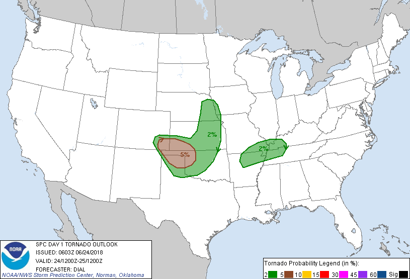
Enid, OK...Garden City, KS...Dodge City, KS...Yukon, OK...Liberal, KS...
SLIGHT
204,439
10,924,255
Oklahoma City, OK...Kansas City, MO...Omaha, NE...Tulsa, OK...Wichita, KS...
MARGINAL
269,914
20,184,447
Memphis, TN...Nashville, TN...Colorado Springs, CO...St. Louis, MO...Louisville, KY...
Probabilistic Tornado Graphic
Probability of a tornado within 25 miles of a point. Hatched Area: 10% or greater probability of EF2 - EF5 tornadoes within 25 miles of a point.
Day 1 Tornado Risk
Area (sq. mi.)
Area Pop.
Some Larger Population Centers in Risk Area
5 %
41,435
342,238
Garden City, KS...Dodge City, KS...Liberal, KS...Pampa, TX...Dumas, TX...
2 %
142,397
7,342,187
Oklahoma City, OK...Omaha, NE...Wichita, KS...Lincoln, NE...Amarillo, TX...
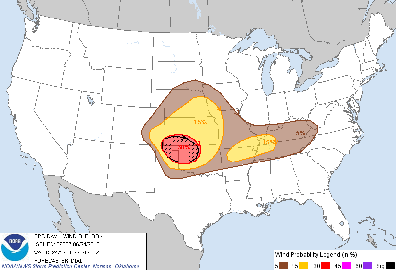
Probabilistic Damaging Wind Graphic
Probability of damaging thunderstorm winds or wind gusts of 50 knots or higher within 25 miles of a point. Hatched Area: 10% of greater probability of wind gusts 65 knots or greater within 25 miles of a point.
Day 1 Wind Risk
Area (sq. mi.)
Area Pop.
Some Larger Population Centers in Risk Area
SIG SEVERE
39,338
411,774
Enid, OK...Dodge City, KS...Liberal, KS...Woodward, OK...Elk City, OK...
30 %
47,514
685,322
Enid, OK...Garden City, KS...Dodge City, KS...Yukon, OK...Liberal, KS...
15 %
204,627
10,994,862
Oklahoma City, OK...Kansas City, MO...Omaha, NE...Tulsa, OK...Wichita, KS...
5 %
270,085
20,148,404
Memphis, TN...Nashville, TN...Colorado Springs, CO...St. Louis, MO...Louisville, KY...
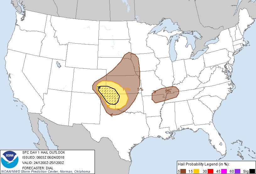
Probabilistic Large Hail Graphic
Probability of hail 1" or larger within 25 miles of a point. Hatched Area: 10% or greater probability of hail 2" or larger within 25 miles of a point.
Day 1 Hail Risk
Area (sq. mi.)
Area Pop.
Some Larger Population Centers in Risk Area
SIG SEVERE
32,635
261,050
Garden City, KS...Liberal, KS...Pampa, TX...Borger, TX...Woodward, OK...
15 %
80,783
740,886
Enid, OK...Garden City, KS...Dodge City, KS...Yukon, OK...Altus, OK...
5 %
198,509
9,122,181
Oklahoma City, OK...Omaha, NE...Tulsa, OK...Wichita, KS...Lincoln, NE...
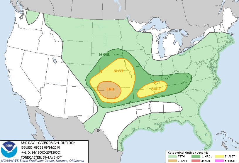
   SPC AC 240603

   Day 1 Convective Outlook
   NWS Storm Prediction Center Norman OK
   0103 AM CDT Sun Jun 24 2018

   Valid 241200Z - 251200Z

   ...THERE IS AN ENHANCED RISK OF SEVERE THUNDERSTORMS OVER A PORTION
   OF THE CENTRAL AND SOUTHERN PLAINS...

   ...THERE IS A SLIGHT RISK OF SEVERE THUNDERSTORMS OVER A PORTION OF
   THE CENTRAL AND SOUTHERN PLAINS AND THE LOWER MISSISSIPPI VALLEY AND
   TENNESSEE VALLEY AREAS...

   ...SUMMARY...
   Severe storms capable of a significant damaging wind, large hail and
   possibly a few tornadoes are expected from southeast Colorado
   through southwest Kansas, the Texas and Oklahoma Panhandles and
   northwest Oklahoma. A few severe storms are also possible from
   northeast Kansas into eastern Nebraska, and from southeast Missouri
   toward Tennessee and Kentucky.

   ...Synopsis...

   Shortwave trough currently centered over southwest MT will advance
   southeast today, reaching the central High Plains this afternoon. A
   cold front from SD through northeast CO is advancing south and will
   reach south CO later this afternoon. Preceding the cold front an
   outflow boundary associated with ongoing storms is expected to lay
   out across OK and extend west into the TX panhandle at the start of
   this period. This boundary may retreat slowly northward as far as
   southwest KS during the afternoon.

   ...Central and southern High Plains region...

   Indications are that the MCS currently over northwest OK will still
   be in progress with some threat for damaging wind at the start of
   this period, and this activity will continue east. The storms will
   lay out an expansive outflow boundary that will extend west into the
   TX Panhandle, and this boundary may retreat slowly northward during
   the day. The atmosphere south of the outflow boundary is expected to
   become strongly unstable with 3000+ J/kg MLCAPE, but with a capping
   inversion resulting from warm air at the base of an elevated mixed
   layer which may limit additional development much of the day.
   However, increasing northeasterly upslope flow over the higher
   terrain of southeast CO accompanying the trailing portion of the
   cold front may contribute to thunderstorm initiation later in the
   afternoon. Additional storms may develop along the dryline/outflow
   boundary intersection over the TX Panhandle. A mid-level jet
   accompanying the mid-latitude shortwave trough will spread through
   the central/southern high Plains above easterly low-level winds
   resulting in sufficient effective bulk shear for some supercells.
   Large hail, and possibly a couple of tornadoes will be the initial
   threats. But storms may eventually grow upscale into an MCS and
   continue east in vicinity of the outflow boundary with damaging wind
   becoming the primary threat into the evening across southern KS into
   northern and central OK.

   ...Northeast KS through east Nebraska...

   Storms are expected to develop along the cold front where the
   atmosphere will become moderately unstable during the afternoon.
   Wind profiles will undergo some increase with the approach of the
   upper trough with 30-35 kt effective bulk shear supportive of
   multicells and possibly some supercell structures capable of
   damaging wind and large hail through mid evening.

   ...Northern Arkansas, southern Missouri through west Tennessee and
   Kentucky...

   Storms will be ongoing over eastern OK and possibly as far east as
   western AR at the start of this period. The downstream atmosphere
   will become moderately unstable, and the remnant progressive MCV may
   promote the development of additional storms as it advances east.
   Storms may organize into line segments and pose a threat for mainly
   damaging wind through the afternoon.

   ..Dial/Wendt.. 06/24/2018

   CLICK TO GET WUUS01 PTSDY1 PRODUCT

   NOTE: THE NEXT DAY 1 OUTLOOK IS SCHEDULED BY 1300Z