St. Louis, MO...Lubbock, TX...Grand Rapids, MI...Lansing, MI...South Bend, IN...
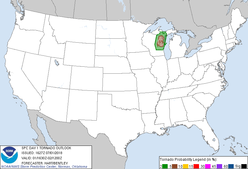
Probabilistic Tornado Graphic
Probability of a tornado within 25 miles of a point. Hatched Area: 10% or greater probability of EF2 - EF5 tornadoes within 25 miles of a point.
Day 1 Tornado Risk
Area (sq. mi.)
Area Pop.
Some Larger Population Centers in Risk Area
5 %
7,527
749,909
Green Bay, WI...Appleton, WI...Neenah, WI...De Pere, WI...Ashwaubenon, WI...
2 %
14,957
734,385
Oshkosh, WI...Fond du Lac, WI...Manitowoc, WI...Stevens Point, WI...Weston, WI...
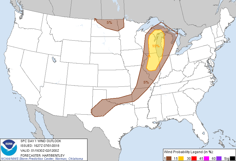
Probabilistic Damaging Wind Graphic
Probability of damaging thunderstorm winds or wind gusts of 50 knots or higher within 25 miles of a point. Hatched Area: 10% of greater probability of wind gusts 65 knots or greater within 25 miles of a point.
SPC AC 011627
Day 1 Convective Outlook
NWS Storm Prediction Center Norman OK
1127 AM CDT Sun Jul 01 2018
Valid 011630Z - 021200Z
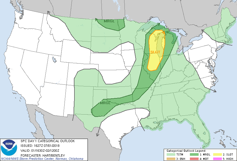
...THERE IS A SLIGHT RISK OF SEVERE THUNDERSTORMS OVER PARTS OF
WESTERN MICHIGAN...WISCONSIN...ILLINOIS...AND NORTHWEST INDIANA...
...SUMMARY...
Strong to severe thunderstorms are expected today from Illinois and
northwest Indiana into Wisconsin and portions of Michigan.
...Michigan/Wisconsin/Illinois/Indiana...
No significant changes have been made to the forecast for this
update. A potent shortwave trough is tracking eastward across
MN/IA. Lift ahead of this feature will promote rapid thunderstorm
development this afternoon along an axis from central WI into
central IL. Strong heating is occurring in this zone, with
temperatures warming well into the 80s and ample low level moisture.
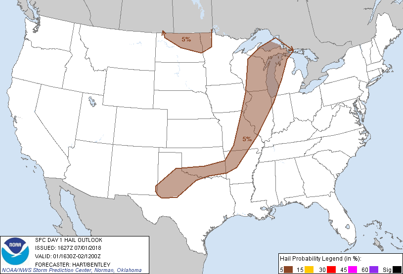
Strong instability will promote intense storms capable of hail and
gusty winds. A few supercells with some tornado risk are possible
today over eastern WI and western Upper MI where models consistently
show favorable low/deep layer wind fields. Otherwise, a transition
of linear structures and locally damaging wind gusts should be the
main threat through mid evening.
...MO/AR into OK/TX...
Remnant outflow boundaries from prior convection extend from
south-central MO into southern OK. Strong instability will develop
along/south of this boundary, where scattered afternoon
thunderstorms are forecast. A few of the storms may produce
damaging wind gusts and hail. This activity is likely to be chaotic
and poorly organized due to weak winds aloft. One exception could
be in vicinity of a remnant MCV over northwest TX that might help to
organize the convection over north TX and southern OK later today.
...ND...
A few strong to severe storms are possible this afternoon and
evening over ND as an upper trough and associated pocket of cooler
temperatures aloft track across the region. Hail is the main
threat.
...New England...
A hot and humid day will occur over much of northern New England
today, with rather large CAPE values and favorable vertical shear.
This will result in a conditional severe threat for any sustained
thunderstorms that can form. However, weak upper ridging, minimal
forcing mechanisms, and some capping will greatly limit the coverage
of convection today. Have removed the MRGL risk for this area due
to large forecast uncertainty, but will re-assess later today if
timing/position of convection initiation becomes more certain.
..Hart/Bentley.. 07/01/2018
CLICK TO GET WUUS01 PTSDY1 PRODUCT
NOTE: THE NEXT DAY 1 OUTLOOK IS SCHEDULED BY 2000Z