Probability of a tornado within 25 miles of a point. Hatched Area: 10% or greater probability of EF2 - EF5 tornadoes within 25 miles of a point.
Day 1 Tornado Risk
Area (sq. mi.)
Area Pop.
Some Larger Population Centers in Risk Area
2 %
6,175
30,590
No Major Population Center in Risk Area
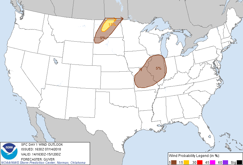
Probabilistic Damaging Wind Graphic
Probability of damaging thunderstorm winds or wind gusts of 50 knots or higher within 25 miles of a point. Hatched Area: 10% of greater probability of wind gusts 65 knots or greater within 25 miles of a point.
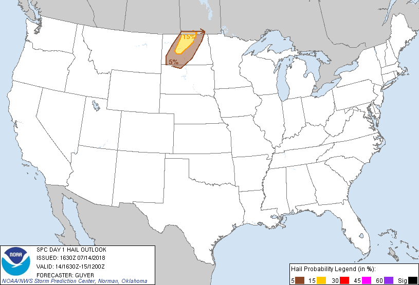
Probability of hail 1" or larger within 25 miles of a point. Hatched Area: 10% or greater probability of hail 2" or larger within 25 miles of a point.
Day 1 Hail Risk
Area (sq. mi.)
Area Pop.
Some Larger Population Centers in Risk Area
15 %
11,156
108,327
Minot, ND...
5 %
27,189
198,107
Bismarck, ND...Mandan, ND...Dickinson, ND...Devils Lake, ND...
   SPC AC 141630

   Day 1 Convective Outlook
   NWS Storm Prediction Center Norman OK
   1130 AM CDT Sat Jul 14 2018

   Valid 141630Z - 151200Z

   ...THERE IS A SLIGHT RISK OF SEVERE THUNDERSTORMS ACROSS
   NORTH-CENTRAL NORTH DAKOTA...

   ...SUMMARY...
   Isolated severe storms are possible over north-central North Dakota
   between 5 to 10 pm CDT.

   ...North Dakota....
   A narrow corridor of moderate buoyancy with MLCAPE of 1500-2000 J/kg
   is expected to develop along a cold front that will progress
   southeast this afternoon and evening. While low-level winds will
   veer ahead of the front, an anticyclone impinging from the Canadian
   Rockies will aid in a strengthening pressure gradient and
   convergence along the front late afternoon to early evening.
   Scattered storms will likely form from northwest South Dakota to
   southwest Manitoba. On the fringe of the mid-level jet ejecting
   across the southern Prairie Provinces, effective shear should range
   30-35 kt across north-central ND. Ample buoyancy and speed shear in
   the upper levels may prove favorable for a couple supercells
   producing quarter to golf ball size hail. Farther south, multicells
   will dominate with strong to isolated severe gusts the primary
   hazard. Activity should quickly weaken near to just after sunset
   owing to a dearth of instability across eastern SD and most of MN.

   ...Middle Mississippi River Valley...
   An early-day cluster of strong/locally severe storms has largely
   weakened across eastern Illinois at late morning. On the periphery
   of this activity, surface heating of a moist air mass characterized
   by upper 60s to lower 70s surface dew points will result in a broad
   corridor of moderate MLCAPE from 1500-2500 J/kg. Afternoon storm
   development will be aided by a couple of eastward-moving MCVs noted
   over eastern Iowa and eastern Kansas. While effective shear should
   only range 15-25 kt, at least a few multicell clusters will yield a
   risk for isolated 35-55 kt wind gusts into early evening.

   ..Guyer/Peters.. 07/14/2018

   CLICK TO GET WUUS01 PTSDY1 PRODUCT

   NOTE: THE NEXT DAY 1 OUTLOOK IS SCHEDULED BY 2000Z