New York, NY...Philadelphia, PA...Baltimore, MD...Boston, MA...Newark, NJ...
MARGINAL
345,723
28,228,917
Denver, CO...Washington, DC...Oklahoma City, OK...Virginia Beach, VA...Tulsa, OK...
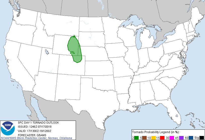
Probabilistic Tornado Graphic
Probability of a tornado within 25 miles of a point. Hatched Area: 10% or greater probability of EF2 - EF5 tornadoes within 25 miles of a point.
Day 1 Tornado Risk
Area (sq. mi.)
Area Pop.
Some Larger Population Centers in Risk Area
2 %
48,924
1,166,551
Fort Collins, CO...Thornton, CO...Greeley, CO...Longmont, CO...Loveland, CO...
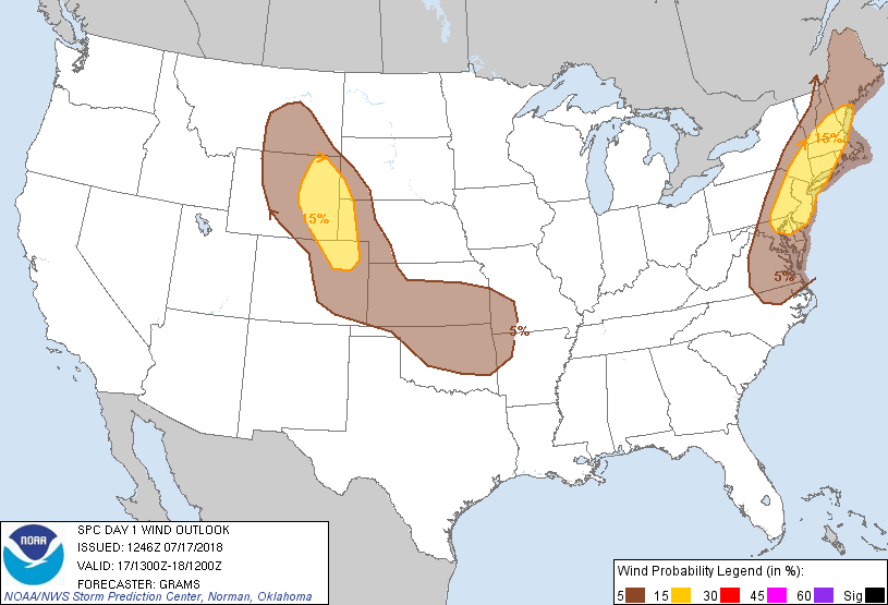
Probabilistic Damaging Wind Graphic
Probability of damaging thunderstorm winds or wind gusts of 50 knots or higher within 25 miles of a point. Hatched Area: 10% of greater probability of wind gusts 65 knots or greater within 25 miles of a point.
Day 1 Wind Risk
Area (sq. mi.)
Area Pop.
Some Larger Population Centers in Risk Area
15 %
99,043
42,563,157
New York, NY...Philadelphia, PA...Baltimore, MD...Boston, MA...Newark, NJ...
5 %
347,297
28,264,981
Denver, CO...Washington, DC...Oklahoma City, OK...Virginia Beach, VA...Tulsa, OK...
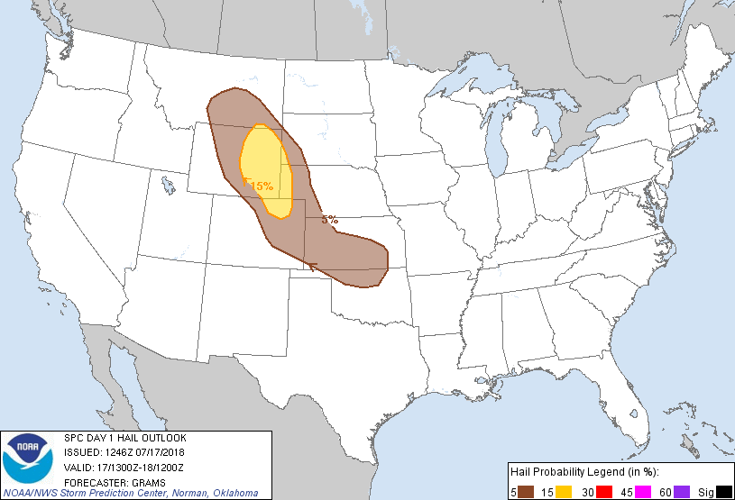
Probabilistic Large Hail Graphic
Probability of hail 1" or larger within 25 miles of a point. Hatched Area: 10% or greater probability of hail 2" or larger within 25 miles of a point.
Day 1 Hail Risk
Area (sq. mi.)
Area Pop.
Some Larger Population Centers in Risk Area
15 %
53,012
612,971
Fort Collins, CO...Greeley, CO...Cheyenne, WY...Casper, WY...Laramie, WY...
5 %
175,668
5,723,790
Denver, CO...Colorado Springs, CO...Wichita, KS...Aurora, CO...Lakewood, CO...
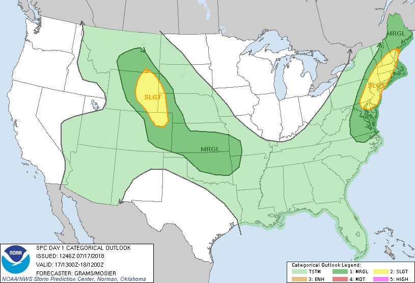
   SPC AC 171246

   Day 1 Convective Outlook
   NWS Storm Prediction Center Norman OK
   0746 AM CDT Tue Jul 17 2018

   Valid 171300Z - 181200Z

   ...THERE IS A SLIGHT RISK OF SEVERE THUNDERSTORMS CENTRAL HIGH
   PLAINS AND THE NORTHEAST...

   ...SUMMARY...
   Scattered severe storms are possible across parts of the Central
   High Plains during the late afternoon and evening. Strong wind gusts
   producing scattered damaging winds are possible over the Northeast
   through early evening.

   ...Central High Plains...
   In the wake of an MCS over central KS, southeasterly surface winds
   will maintain an upslope flow component towards the central/southern
   Rockies. A shortwave trough over the northern Rockies will shift
   east across the northern High Plains. 30-40 kt 500-mb westerlies
   attendant to this feature will overspread much of WY with mid to
   late afternoon storm initiation expected off the higher terrain.
   While deep-layer shear will be stronger relative to Monday,
   deleterious effects of the ongoing MCS on boundary-layer moisture
   should result in a more spatially confined plume of MLCAPE ranging
   from 1000-2000 J/kg. Speed shear through the cloud-bearing layer
   should be sufficient for a supercells with large hail and isolated
   severe gusts the primary hazards. Some upscale growth may occur in
   the evening, but guidance differs greatly on the degree of low-level
   warm advection.

   ...Northeast...
   Scattered storms are ongoing within the warm conveyor ahead of a
   cold front that stretches from the Saint Lawrence Valley southwest
   into the Upper OH Valley. Within a weak mid-level lapse rate
   environment, surface heating will be critical to strong storm
   potential. Early-day visible satellite imagery suggests this will be
   pronounced ahead of the ongoing convection. With pervasive low to
   mid 70s surface dew points, 1000-2000 J/kg MLCAPE should be common.
   While effective shear will remain modest around 20-30 kt, numerous
   storms should foster several multicell clusters by early to mid
   afternoon. Scattered downed trees will be the primary hazard from
   strong wind gusts.

   ...KS/OK...
   Ongoing MCS across central KS has yielded an MCV along the
   north-central KS/south-central NE border with outflow continuing to
   push southeast in southwest KS. CAM and non-CAM guidance have poorly
   handled the spatiotemporal aspects of this MCS. They also widely
   vary in the shear/instability environment and with simulations of
   renewed storm development this afternoon/evening. With a hot air
   mass becoming prevalent south/southwest of the outflow, and a
   moderately buoyant air mass to its southeast, it appears plausible
   that a couple supercells and multicell clusters may develop later
   today. Low confidence in when/where and how that may evolve will
   necessitate deferral on a categorical upgrade.

   ..Grams/Mosier.. 07/17/2018

   CLICK TO GET WUUS01 PTSDY1 PRODUCT

   NOTE: THE NEXT DAY 1 OUTLOOK IS SCHEDULED BY 1630Z