Probability of damaging thunderstorm winds or wind gusts of 50 knots or higher within 25 miles of a point. Hatched Area: 10% of greater probability of wind gusts 65 knots or greater within 25 miles of a point.
Day 1 Wind Risk
Area (sq. mi.)
Area Pop.
Some Larger Population Centers in Risk Area
15 %
155,188
10,260,736
Jacksonville, FL...Orlando, FL...Tallahassee, FL...Gainesville, FL...Spring Hill, FL...
5 %
221,768
20,921,679
Baltimore, MD...Washington, DC...Virginia Beach, VA...Raleigh, NC...Tampa, FL...
Probabilistic Large Hail Graphic
Probability of hail 1" or larger within 25 miles of a point. Hatched Area: 10% or greater probability of hail 2" or larger within 25 miles of a point.
SPC AC 221959
Day 1 Convective Outlook
NWS Storm Prediction Center Norman OK
0259 PM CDT Sun Jul 22 2018
Valid 222000Z - 231200Z
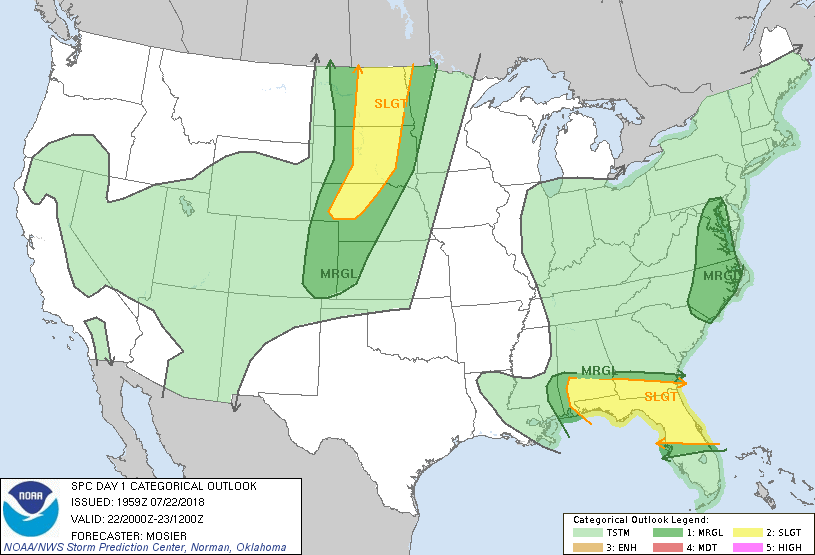
...THERE IS A SLIGHT RISK OF SEVERE THUNDERSTORMS OVER A PORTION OF
THE GULF COAST STATES AS WELL AS THE NORTHERN AND CENTRAL PLAINS...
...SUMMARY...
Severe storms, primarily capable of damaging winds and large hail,
will be possible across parts of the Southeast and northern/central
Plains this afternoon and evening. A few marginally severe storms
are also possible over a portion of the Middle Atlantic region.
...20Z Update...
...Central Gulf Coast into FL...
Very moist and unstable airmass over the region will continue to
support a severe thunderstorm threat. Recent radar imagery shows the
outflow surging southward along the east-central FL coast while
warm-air advection and resultant backbuilding persists farther
northwest towards the FL Big Bend. Outflow-dominant character to the
southeastern portion of the this convective complex suggests a
somewhat diminished severe threat, although isolated damaging wind
gusts remain possible. Relatively higher threat exists across the
backbuilding portion of the cluster as storm interactions and new
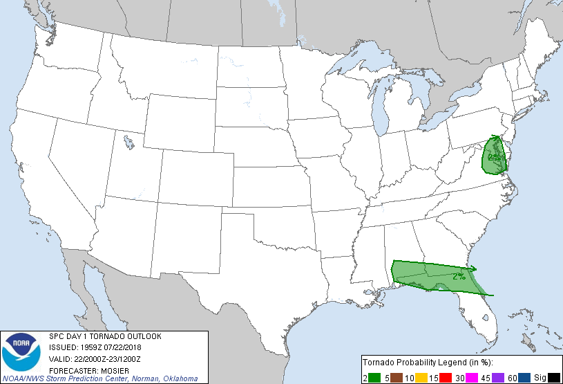
updraft development increase the chances for water loading. Moist
inflow and somewhat stronger southeasterly winds will also support a
low tornado threat in this region.
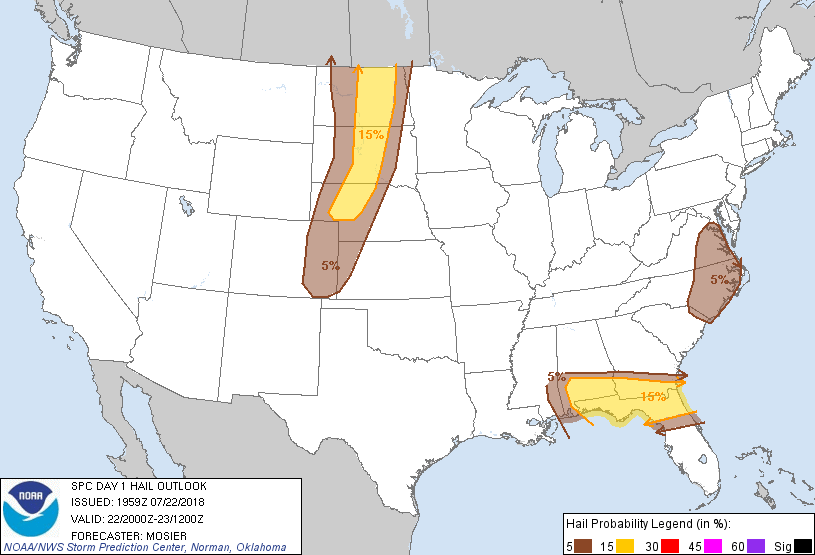
Severe threat also continues across southern AL, southwest GA, and
adjacent portions of the FL Panhandle. In this area, a more discrete
storm mode and stronger shear has lead to the development of several
supercells with the moist and unstable airmass supporting both left
and right splits. Discrete storm mode and more updraft organization
has led to a greater threat for hail here than over areas farther
southeast. Upscale growth into a more coherent convective line which
then tracks across the central FL Peninsula is possible. Subsidence
behind the ongoing storms as well as beneath the right exit region
of the upper jet will likely temper any additional development
across southern AL. Additional short-term details about this area
are available in MCD 1136.
...Northern/Central Plains...
Overall scenario outlined in the previous discussion (appended
below) remains valid with no change needed to the outlook.
Additional short-term information is available in MCD 1135.
...Mid-Atlantic States...
Observational trends and recent guidance suggest the severe threat
across SC has dropped below 5% and the outlook was updated
accordingly. Elsewhere across the region, enhanced mid-level flow
supports occasional bowing line segments and the potential for
damaging wind gusts. Additionally, southeasterly surface winds
across eastern VA result in slightly stronger low-level shear
(sampled well by recent LWX and AKQ VAD wind profiles) and a low
tornado risk.
..Mosier.. 07/22/2018
.PREV DISCUSSION... /ISSUED 1130 AM CDT Sun Jul 22 2018/
...Gulf Coastal area including Florida...
Numerous storms are in the process of developing within the weakly
capped, but moderately unstable environment across northern FL.
These storms will be capable of producing mainly isolated damaging
wind. Additional storms are expected to develop/intensify farther
west along and south of a cold front across southern AL as well as
in association with sea breeze boundaries over the FL Panhandle.
These storms will be embedded within 35-45 kt unidirectional
effective bulk shear within base of upper low circulation. Damaging
wind and large hail will be possible with both multicell and
supercell storm modes.
...Northern through central Plains region...
A shortwave trough will continue east through Saskatchewan and
Manitoba along the international border and eventually affecting
extreme northern ND. A cold front will accompany this feature
through the northern and central Plains today and tonight. A
corridor of moderate instability is likely in pre-frontal warm
sector along with sufficient (35-45 kt) deep-layer shear for
supercells from ND into SD. Storms will likely develop over the
Dakotas later this afternoon posing a risk for isolated large hail
and damaging wind gusts. Other storms might develop farther south
along the front across central NE by early evening where weaker
shear will promote multicells, but the thermodynamic environment
will support some threat for a few instances of damaging wind and
large hail. Other storms will form over the higher terrain of CO and
WY and spread east into the High Plains this afternoon and evening
with a modest threat for damaging wind and hail.
...Middle Atlantic region...
Some destabilization is likely in this region today and potential
will exist for storms to redevelop and interact with a weak warm
front as they lift north. Low-level hodographs in vicinity of this
boundary will support a modest risk for a few low-level
mesoscyclones and a brief tornado or two. Reference SWOMCD 1132 for
more information.
CLICK TO GET WUUS01 PTSDY1 PRODUCT
NOTE: THE NEXT DAY 1 OUTLOOK IS SCHEDULED BY 0100Z