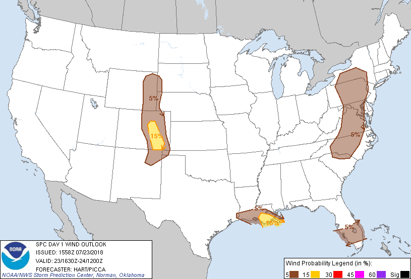
Probability of damaging thunderstorm winds or wind gusts of 50 knots or higher within 25 miles of a point. Hatched Area: 10% of greater probability of wind gusts 65 knots or greater within 25 miles of a point.
Day 1 Wind Risk
Area (sq. mi.)
Area Pop.
Some Larger Population Centers in Risk Area
15 %
23,858
2,462,983
Colorado Springs, CO...Aurora, CO...Pueblo, CO...Highlands Ranch, CO...Centennial, CO...
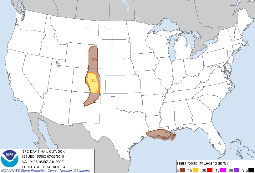
Probability of hail 1" or larger within 25 miles of a point. Hatched Area: 10% or greater probability of hail 2" or larger within 25 miles of a point.
Day 1 Hail Risk
Area (sq. mi.)
Area Pop.
Some Larger Population Centers in Risk Area
15 %
23,291
3,833,738
Denver, CO...Colorado Springs, CO...Aurora, CO...Lakewood, CO...Thornton, CO...
5 %
77,779
3,844,853
New Orleans, LA...Baton Rouge, LA...Metairie, LA...Fort Collins, CO...Lafayette, LA...
SPC AC 231558
Day 1 Convective Outlook
NWS Storm Prediction Center Norman OK
1058 AM CDT Mon Jul 23 2018
Valid 231630Z - 241200Z
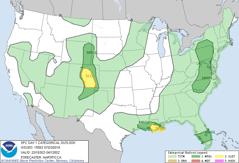
...THERE IS A SLIGHT RISK OF SEVERE THUNDERSTORMS OVER PARTS OF
CENTRAL COLORADO...AND PORTIONS OF SOUTHEAST LOUISIANA...
...SUMMARY...
A few severe storms will be possible across southern Louisiana, and
over parts of central/eastern Colorado today. Elsewhere, strong to
marginally severe storms will be possible over parts of the Florida
Peninsula and Mid-Atlantic region, primarily this afternoon and
evening.
...Central Rockies and High Plains...
A large upper ridge is centered over NM today, with the southern
fringe of stronger westerlies over parts of UT/CO. Strong heating
is occurring over the mountains of central CO, where sufficient low
level moisture is present for the development of scattered afternoon
thunderstorms. Forecast soundings show sufficient CAPE and
effective shear for a risk of large hail in the stronger cells over
the mountains. As the storms move off the higher terrain, the
primary threat will likely transition to strong/damaging winds
before activity weakens after dark.
...Southeast LA...
A weak surface cold front continues to sag southward across LA,
separating dewpoints in the 70s to the north, from near 80F to the
south. This area is beneath rather strong northerly mid/upper level
flow, sufficient for storm organization and some severe threat. The
main complicating factor to the forecast today is the substantial
mid/high cloudiness spreading across this area, limiting
heating/destabilization. Will maintain the SLGT risk for now but
confidence in a more active severe weather event is decreasing.
...NY/PA southward into the Carolinas...
A moist and moderately unstable air mass is present today over much
of the Mid-Atlantic region, beneath a band of moderately strong
southerly mid-level winds. Several weak shortwave troughs are
evident in water vapor imagery lifting northward across the region,
which will support the development of scattered afternoon
thunderstorms. Substantial cloud cover is limiting heating and will
likely preclude a more organized severe threat. Nevertheless, the
strongest cells will be capable of gusty or locally damaging
wind gusts through the afternoon.
...Central FL...
Strong heating is occurring over central FL today, ahead of a large
convective complex over the eastern Gulf. Vertical shear is weak
across this region, but ample moisture/CAPE and boundary
interactions may result in a few intense storms with gusty/damaging
winds.
..Hart/Picca.. 07/23/2018
CLICK TO GET WUUS01 PTSDY1 PRODUCT
NOTE: THE NEXT DAY 1 OUTLOOK IS SCHEDULED BY 2000Z