Omaha, NE...Madison, WI...Green Bay, WI...Rochester, MN...Sioux City, IA...
MARGINAL
266,998
13,009,025
Milwaukee, WI...Denver, CO...Colorado Springs, CO...Minneapolis, MN...Aurora, CO...
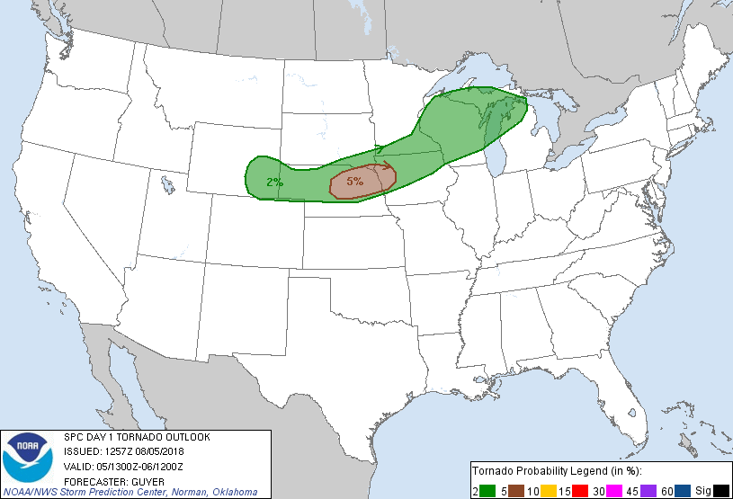
Probabilistic Tornado Graphic
Probability of a tornado within 25 miles of a point. Hatched Area: 10% or greater probability of EF2 - EF5 tornadoes within 25 miles of a point.
Day 1 Tornado Risk
Area (sq. mi.)
Area Pop.
Some Larger Population Centers in Risk Area
5 %
26,440
550,557
Sioux City, IA...Fremont, NE...Norfolk, NE...Columbus, NE...Yankton, SD...
2 %
185,073
7,441,776
St. Paul, MN...Madison, WI...Sioux Falls, SD...Green Bay, WI...Rochester, MN...
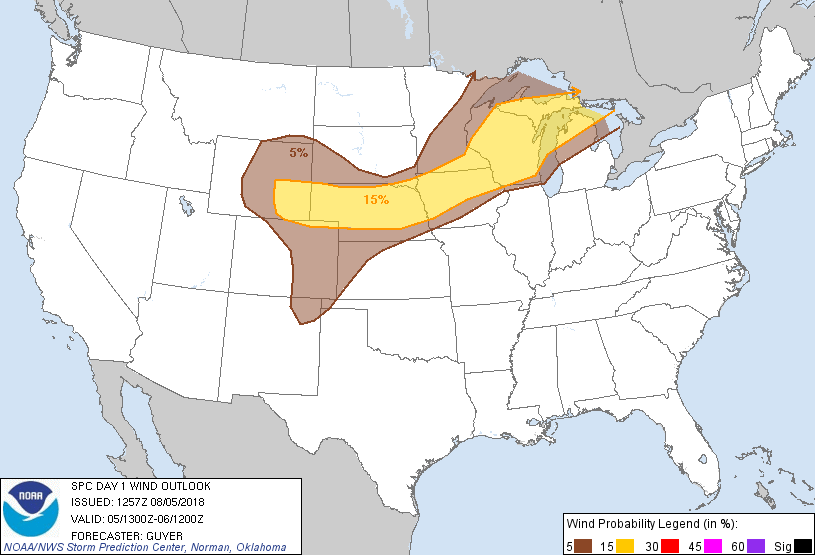
Probabilistic Damaging Wind Graphic
Probability of damaging thunderstorm winds or wind gusts of 50 knots or higher within 25 miles of a point. Hatched Area: 10% of greater probability of wind gusts 65 knots or greater within 25 miles of a point.
Day 1 Wind Risk
Area (sq. mi.)
Area Pop.
Some Larger Population Centers in Risk Area
15 %
211,240
8,746,889
Milwaukee, WI...Omaha, NE...Madison, WI...Green Bay, WI...Rochester, MN...
5 %
259,534
12,698,275
Denver, CO...Colorado Springs, CO...Minneapolis, MN...Aurora, CO...St. Paul, MN...
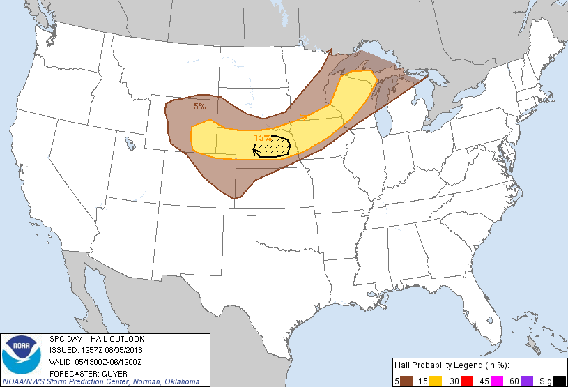
Probabilistic Large Hail Graphic
Probability of hail 1" or larger within 25 miles of a point. Hatched Area: 10% or greater probability of hail 2" or larger within 25 miles of a point.
Day 1 Hail Risk
Area (sq. mi.)
Area Pop.
Some Larger Population Centers in Risk Area
SIG SEVERE
16,704
237,140
Grand Island, NE...Norfolk, NE...Columbus, NE...
15 %
161,576
4,652,228
Omaha, NE...Rochester, MN...Sioux City, IA...Waterloo, IA...Eau Claire, WI...
SPC AC 051257
Day 1 Convective Outlook
NWS Storm Prediction Center Norman OK
0757 AM CDT Sun Aug 05 2018
Valid 051300Z - 061200Z
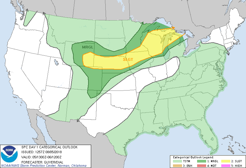
...THERE IS A SLIGHT RISK OF SEVERE THUNDERSTORMS FROM THE CENTRAL
HIGH PLAINS TO THE UPPER GREAT LAKES...
...SUMMARY...
Isolated to scattered severe storms, capable of large hail, damaging
winds, and a couple tornadoes, will be possible from parts of the
central High Plains to northern Michigan today.
...Central High Plains to the Mid-Missouri River Valley...
A somewhat complex convective scenario is expected today.
Regardless, this region will be susceptible to multiple rounds of
potentially severe convection this afternoon and tonight with all
convectively related hazards possible during the period, especially
across Nebraska into Iowa where strong consideration of a
categorical Enhanced Risk upgrade was given.
Outflow continues to stall/gradually wash-out across northeast
Nebraska/western Iowa with some regenerative convective development
atop a surface cold pool in the wake an overnight
severe-wind-producing MCS. Some sub-regional spatial uncertainty
exists regarding the severe risk later today due to this, although
gradual air mass recovery can be expected in most of these
MCS/outflow-impacted areas.
The region will be influenced by multiple eastward-spreading
mid-level disturbances within a belt of strengthening mid/high-level
westerlies (50+ kt in some cases), which will be relatively strong
by August standards. One such disturbance is across southeast
Wyoming/northern Colorado this morning. Ascent/mass response related
to this feature could influence increasing severe storm development
by mid/late afternoon in and around east-central Nebraska and points
east through evening. A secondary semi-focused belt of ascent,
related to a shortwave trough over the north-central Great Basin,
will also be a factor of severe storms from interior Wyoming this
afternoon eastward into Nebraska, potentially in the form of an MCS
tonight.
Coincident with cloud-filtered insolation and a strong elevated
mixed layer, pockets of strong heating through the day will combine
with surface dew points in the upper 60s/lower 70s and steep
mid-level lapse rates to yield MLCAPE upwards of 2500-3000 J/kg
across parts of central Nebraska. A south/southwesterly low-level
jet is expected to strengthen over central/eastern Nebraska by
evening, with scattered storms possibly developing from
central/eastern Nebraska into western Iowa near a
southwest-northeast oriented surface trough/effective warm front. In
addition to a large hail and damaging wind threat, a localized
enhancement in tornado potential may exist, owing to greater
storm-relative helicity in association with the amplifying low-level
jet. Over time, though, storm mergers should support damaging winds
becoming the main threat.
Farther west towards Wyoming, MLCAPE values should be closer to
500-1500 J/kg. As mentioned, one focused area of convective
initiation is expected here related to the secondary mid-level
impulse influencing increasing storm development over the higher
terrain. Aided by favorable easterly/upslope flow and ample
effective shear, these cells (likely in the form of supercells)
should intensify as they move towards southeast Wyoming and the
Nebraska Panhandle, with a potential for damaging winds, large hail,
and perhaps a tornado. Over time, the steep lapse-rate environment
and layers of dry air aloft could foster a transition to small-scale
bows, with a primary threat of severe wind gusts into the overnight
as storms move eastward across Nebraska potentially as a
well-organized/eastward-accelerating MCS.
...Portions of Minnesota/Wisconsin/Michigan...
To the north of the overnight/early morning MCS, a corridor of
relatively unperturbed unstable air remains especially across areas
such as south-central/eastern Minnesota. This is confirmed by the
12Z observed sounding from Minneapolis which featured a relatively
steep mid-level lapse rate with 3000+ J/kg MLCAPE, and to a lesser
extent at International Falls MN where a 7.3 C/km lapse rate was
noted per the 12Z sounding. While the decaying early-day MCS to the
south and any related MCV complicates the scenario, a modestly
amplifying shortwave trough along the international border vicinity
of northern Minnesota may influence diurnally increasing severe
potential coincident with the previously highlighted plume of
relatively unstable air as it advects east/northeastward coincident
with a warming boundary layer.
Accordingly, at least some severe risk appears probable from
east-central/northeast Minnesota into northern Wisconsin and Upper
Michigan this afternoon into evening given that 40-50 kt mid-level
flow will overlie a warm/moist boundary layer. In tandem with fairly
steep 700-500mb lapse rates, this thermodynamic environment will
offer a stout, but probable severe threat where storms
develop/mature. Relatively unidirectional flow suggests damaging
winds will be the predominant severe threat, but supercells are
possible and favorable low-level and deep-layer speed shear may
support a few instances of large hail and perhaps a tornado.
..Guyer/Dial.. 08/05/2018
CLICK TO GET WUUS01 PTSDY1 PRODUCT
NOTE: THE NEXT DAY 1 OUTLOOK IS SCHEDULED BY 1630Z