Denver, CO...Colorado Springs, CO...Aurora, CO...Lubbock, TX...Amarillo, TX...
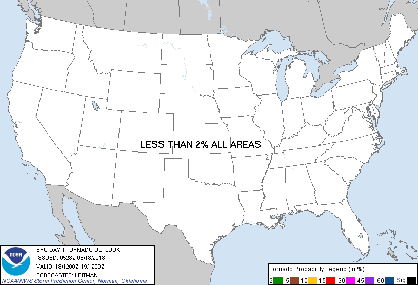
Probabilistic Tornado Graphic
Probability of a tornado within 25 miles of a point. Hatched Area: 10% or greater probability of EF2 - EF5 tornadoes within 25 miles of a point.
Day 1 Tornado Risk
Area (sq. mi.)
Area Pop.
Some Larger Population Centers in Risk Area
No Risk Areas Forecast
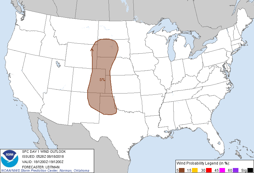
Probabilistic Damaging Wind Graphic
Probability of damaging thunderstorm winds or wind gusts of 50 knots or higher within 25 miles of a point. Hatched Area: 10% of greater probability of wind gusts 65 knots or greater within 25 miles of a point.
Day 1 Wind Risk
Area (sq. mi.)
Area Pop.
Some Larger Population Centers in Risk Area
5 %
218,793
5,050,511
Denver, CO...Colorado Springs, CO...Aurora, CO...Lubbock, TX...Amarillo, TX...
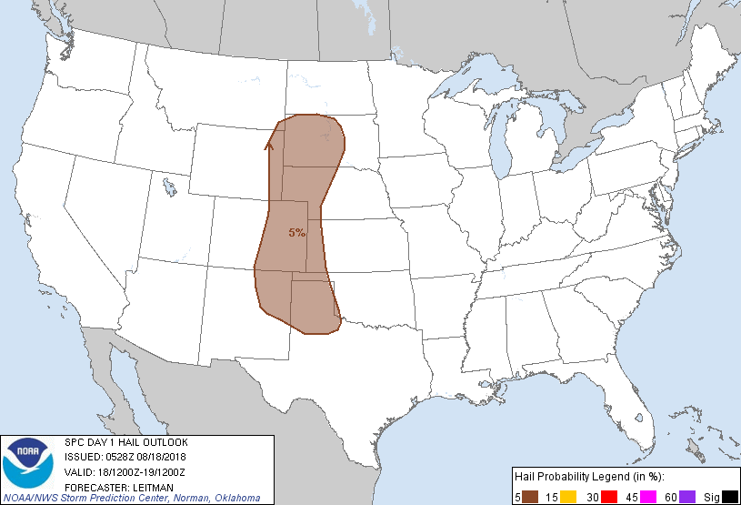
Probabilistic Large Hail Graphic
Probability of hail 1" or larger within 25 miles of a point. Hatched Area: 10% or greater probability of hail 2" or larger within 25 miles of a point.
Day 1 Hail Risk
Area (sq. mi.)
Area Pop.
Some Larger Population Centers in Risk Area
5 %
218,215
4,747,682
Denver, CO...Colorado Springs, CO...Aurora, CO...Lubbock, TX...Amarillo, TX...
SPC AC 180528
Day 1 Convective Outlook
NWS Storm Prediction Center Norman OK
1228 AM CDT Sat Aug 18 2018
Valid 181200Z - 191200Z
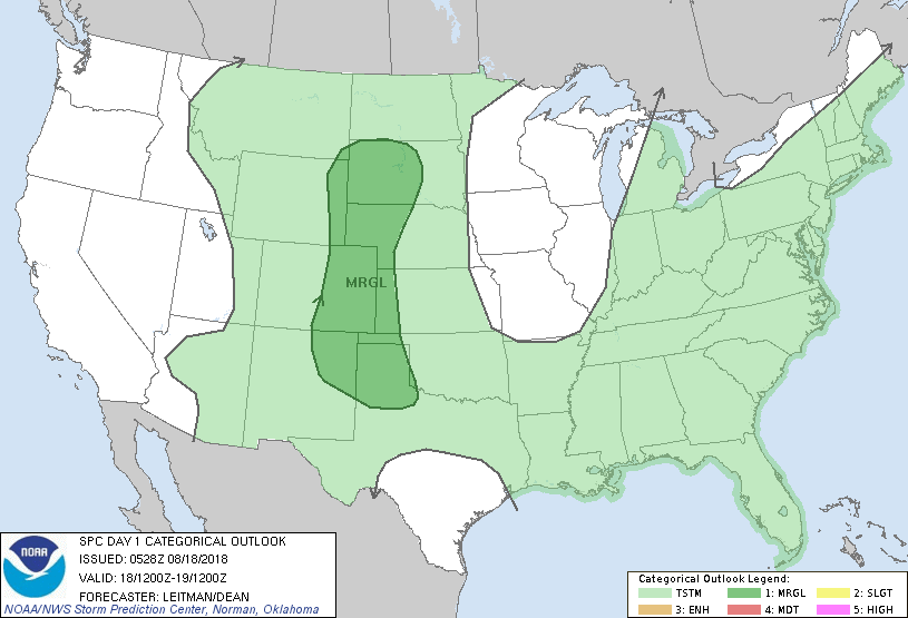
...THERE IS A MARGINAL RISK OF SEVERE THUNDERSTORMS ACROSS THE HIGH
PLAINS THIS AFTERNOON AND EVENING...
...SUMMARY...
Isolated severe storms will be possible across the High Plains
region this afternoon and evening.
...High Plains...
The northern Rockies mid/upper trough will drop east/southeast into
the Plains today and tonight. A weak low/surface trough will extend
across the western Dakotas into northeast CO, with southerly low
level flow maintaining 60s dewpoints across the region. A cold front
will track eastward across eastern MT/WY into the western Dakotas
and northeast CO by around 21-00z. As height falls ensue, 25-35 kt
effective shear will overspread the region. Steepening midlevel
lapse rates and pockets of strong heating will result in a corridor
of 1500-2500 J/kg SBCAPE. Convection will initially develop near
higher terrain by midday and shift eastward into the adjacent High
Plains ahead of the surging cold front. Given linear forcing
mechanism and marginal deep layer shear, multicell clusters and line
segments are expected. Strong, locally damaging wind gusts will be
the main concern, though some marginal hail will be possible in
strongest cores or in any cells than can remain discrete given lapse
rates approaching 7-8 C/km.
Across southern portions of the Marginal risk from southwest KS into
the OK/TX Panhandles, ongoing convection and cloud cover may limit
thunderstorm potential for much of the day as destabilization will
be delayed compared to points further north. This could result in a
more conditional severe threat since any storms developing during
the evening would likely be elevated, diminishing the threat of
strong winds.
...Mid-Atlantic Vicinity...
An upper trough will shift eastward from the OH/TN Valley region to
the Atlantic coast by Sunday morning. A moist and unstable airmass
coupled with weak forcing for ascent ahead of the trough will result
in widespread thunderstorm development. Upper 60s to low 70s
dewpoints will be in place across the NC/VA Piedmont into the
Chesapeake vicinity. While pockets of moderate instability are
expected, modest deep shear profiles and poor lapse rates will limit
severe potential. Nonetheless, a few strong wind gusts are possible
as PW values approaching 2 inches could result in a wet microburst
or two.
..Leitman/Dean.. 08/18/2018
CLICK TO GET WUUS01 PTSDY1 PRODUCT
NOTE: THE NEXT DAY 1 OUTLOOK IS SCHEDULED BY 1300Z