Boston, MA...Virginia Beach, VA...Colorado Springs, CO...Norfolk, VA...Chesapeake, VA...
Probabilistic Tornado Graphic
Probability of a tornado within 25 miles of a point. Hatched Area: 10% or greater probability of EF2 - EF5 tornadoes within 25 miles of a point.
Day 1 Tornado Risk
Area (sq. mi.)
Area Pop.
Some Larger Population Centers in Risk Area
No Risk Areas Forecast
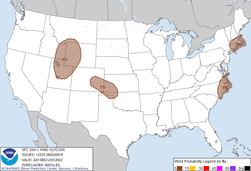
Probabilistic Damaging Wind Graphic
Probability of damaging thunderstorm winds or wind gusts of 50 knots or higher within 25 miles of a point. Hatched Area: 10% of greater probability of wind gusts 65 knots or greater within 25 miles of a point.
Day 1 Wind Risk
Area (sq. mi.)
Area Pop.
Some Larger Population Centers in Risk Area
5 %
197,532
17,763,834
Boston, MA...Virginia Beach, VA...Colorado Springs, CO...Norfolk, VA...Chesapeake, VA...
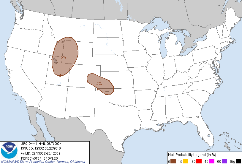
Probabilistic Large Hail Graphic
Probability of hail 1" or larger within 25 miles of a point. Hatched Area: 10% or greater probability of hail 2" or larger within 25 miles of a point.
Day 1 Hail Risk
Area (sq. mi.)
Area Pop.
Some Larger Population Centers in Risk Area
5 %
157,784
4,151,292
Colorado Springs, CO...Salt Lake City, UT...West Valley City, UT...Provo, UT...Pueblo, CO...
SPC AC 221233
Day 1 Convective Outlook
NWS Storm Prediction Center Norman OK
0733 AM CDT Wed Aug 22 2018
Valid 221300Z - 231200Z
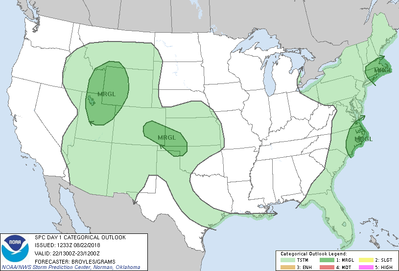
...THERE IS A MARGINAL RISK OF SEVERE THUNDERSTORMS ACROSS PARTS OF
THE GREAT BASIN...NORTHERN ROCKIES...HIGH PLAINS...SOUTHERN NEW
ENGLAND AND SOUTHERN MID ATLANTIC COAST...
...SUMMARY...
Widely scattered strong thunderstorms with marginally severe wind
gusts and hail will be possible in parts of southern New England,
the High Plains and Great Basin into the southern Rockies. A few
marginally severe wind gusts will also be possible along the
southern Mid Atlantic coast.
...Great Basin/Northern Rockies...
A positively tilted shortwave trough will move east-northeastward
across the Intermountain West today as a Pacific cold front advances
eastward across the region. This front should be located in western
Montana, central Idaho and far northwestern Utah by afternoon.
Low-level moisture should be maximized ahead of the front from
eastern Utah into western Wyoming with surface dewpoints generally
in the lower to mid 50s F in the lower elevations. In response,
surface heating should increase MLCAPE values in the 1200 to 1500
J/kg range by late afternoon as is shown on RAP forecast soundings.
This increase in instability should result in scattered thunderstorm
development along and ahead of the front. The instability should be
coincident with moderate deep-layer shear supporting at least a
marginal severe threat. 700 to 500 mb lapse rates of 7.5 to 8.0 C/km
will be conducive for hail with discrete rotating cells. A few
marginally severe wind gusts will be possible as well. A slight risk
could be needed in later outlooks once the exact location of the
strongest instability can be determined.
...Southern and Central High Plains...
A shortwave ridge will move across the central and northern High
Plains today. At the surface, a boundary with maximized low-level
convergence should be located from southeast Colorado
east-southeastward into the Oklahoma Panhandle. As surface
temperatures warm during the day, convection will likely initiate in
the higher terrain of south-central Colorado and southeastward along
the boundary. Thunderstorms should then spread eastward into the
lower elevations of southeast Colorado, southwest Kansas and the
Oklahoma Panhandle. RAP forecast soundings along this corridor by
00Z/Thursday show MLCAPE values generally between 1500 and 2500
J/kg. The Lamar, CO forecast sounding is the anomaly peaking near
2900 J/kg. The instability combined with 0-6 km in the 25 to 35 kt
range should be enough for an isolated severe threat. A few
marginally severe wind gusts will be possible with the stronger
multicells. In spite of the relatively poor lapse rates, the
stronger updrafts could also have hail in areas that destabilize the
most.
...Southern New England...
An upper-level trough will move eastward across southeast Canada,
the lower Great Lakes and the Ohio Valley today. At the surface, a
cold front will advance eastward into New England. Surface dewpoints
ahead of this feature will be in the mid to upper 60s F aiding the
development of a pocket of instability across southern New England
around midday. Isolated thunderstorms are forecast to initiate along
the front and move eastward across southern New England from late
this morning into early afternoon. RAP forecast soundings around
midday show weak instability in southern New England but have 0-6 km
shear in the 30 to 40 kt range. This could be enough for marginally
severe wind gusts with short line segments.
...Southern Mid Atlantic Coast...
An upper-level trough will move eastward across the lower Great
Lakes and Ohio Valley today as a cold front advances eastward into
the Mid Atlantic and Carolinas. Ahead of the front, surface
dewpoints in the mid 60s to lower 70s F should result in a corridor
of moderate instability by afternoon along the coasts of Georgia and
the Carolinas. Near the axis of strongest instability, the 21Z RAP
forecast soundings at Wilmington, NC has MLCAPE around 2500 J/kg
with 0-6 km shear of 25 kt. This combined with steep low-level lapse
rates may be enough for marginally severe wind gusts.
..Broyles/Grams.. 08/22/2018
CLICK TO GET WUUS01 PTSDY1 PRODUCT
NOTE: THE NEXT DAY 1 OUTLOOK IS SCHEDULED BY 1630Z