SPC AC 051259
Day 1 Convective Outlook
NWS Storm Prediction Center Norman OK
0759 AM CDT Wed Sep 05 2018
Valid 051300Z - 061200Z
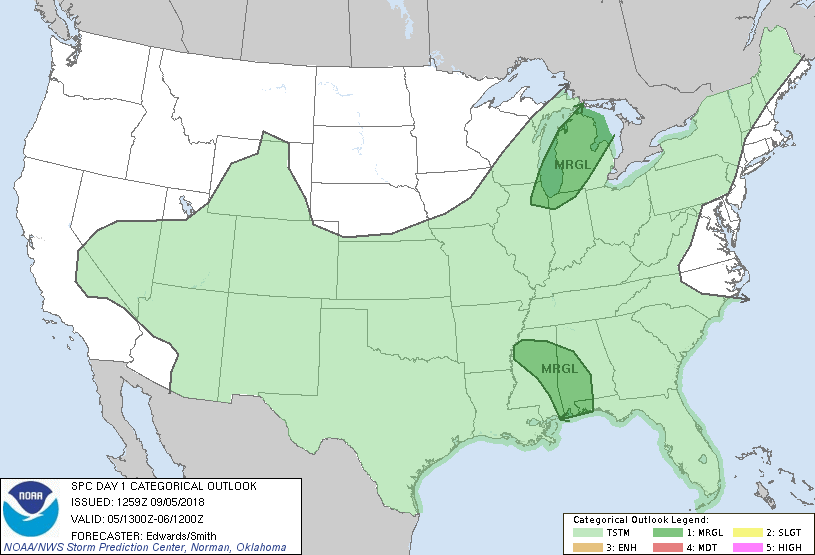
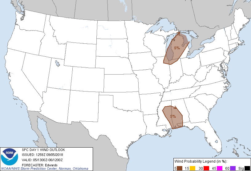
...THERE IS A MARGINAL RISK OF SEVERE THUNDERSTORMS OVER PARTS OF
THE UPPER GREAT LAKES REGION AND THE CENTRAL GULF COAST TO NORTHERN
MISSISSIPPI...
...SUMMARY...
Damaging thunderstorm winds are possible over parts of the Upper
Great Lakes region. The weakening remnants of Gordon may produce a
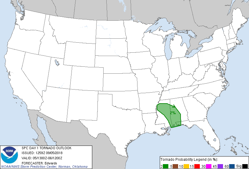
tornado or two over the central Gulf Coast inland across
Mississippi.
...Synopsis...
In mid/upper levels, the CONUS part of the large-scale pattern will
continue to be characterized by weak, broad troughing over the West,
and an anticyclone slowly weakening and drifting eastward across and
offshore from the Tidewater/Delmarva region. The main belt of
midlatitude westerlies will remain over or north of the Canadian
border through the period. That flow belt will be perturbed
primarily by a positively tilted shortwave trough -- now evident in
moisture-channel imagery from a cyclone over southwestern Hudson Bay
across far northwestern ON, south-central MB, to near the SK/ND/MT
border junction. The southern lobe of this trough is forecast to
pivot southeastward and eastward across the Lake Superior region
this evening and overnight, reaching northern Lake Huron by 12Z.
At the surface, a cold front was analyzed from a low over eastern
Upper MI southwestward over southwestern WI, southwestern IA,
southwestern KS and north-central NM. By the end of the period,
this front should advance to northern ME, western NY, southern IN,
and northwest TX.
...Upper Great Lakes...
Scattered thunderstorms should develop primarily this afternoon near
the cold front and move northeastward across the outlook area,
offering the potential for isolated damaging to severe gusts.
In between the upper ridging and the northern-stream westerlies, a
broad regime of confluent mid/upper-level flow will overlie a
corridor of high-PW, low-level, prefrontal moisture transport from
the central Plains northeastward across the outlook area. Satellite
imagery indicates the boundary layer will experience sustained
insolation southeast of the front, combining with rich boundary-
layer moisture to boost MLCAPE to around 1500 J/kg over Lower MI,
and near 2000 J/kg over northeastern IL. The area will reside on or
just outside the southeast edge of appreciable midlevel winds
associated with the shortwave trough, but beneath a departing,
35-45-kt channel of flow near 850-mb that will boost low-level speed
shear. Messy modes and lack of more robust mid/upper winds (and
therefore lack of deep shear) will limit the overall organization of
severe potential. The threat should diminish overnight as the
boundary layer gradually stabilizes, concurrent with a reduction in
low-level frontal convergence.
...Remnants of Gordon...
A few small supercells and a brief tornado or two still are possible
mainly over the eastern semicircle of the northwestward-translating
circulation, where at least marginal juxtaposition of buoyancy and
shear still is possible. With time, the center of circulation will
become more displaced from the area of most favorable instability,
while the low-level flow and shear gradually diminish regionally.
However, MLCINH will be weak, with convergence and heating-related
lift in the eastern and southeastern parts of the circulation
remaining sufficient to support both bands and discrete cells.
Breaks and slots in the cloud cover may allow sufficient diurnal
heating to offset poor low/middle-level lapse rates and boost MLCAPE
to values ranging from less then 500 J/kg northeast of center to the
1500-2000 J/kg range on the outer southeastern fringes of the
vortex. With the cyclone remaining small in size, the increasing
buoyancy with eastward-southeastward distance will be offset
substantially by weaker overall low-level flow in the outer
envelope, both with distance from center and with time.
....Ohio Valley to northeastern international border...
Isolated thunderstorms may develop across the area between the Ohio
Valley, northern Appalachians and international border. Other than
perhaps a lake-breeze or differential-heating boundary, forcing for
low-level ascent appears weak at best, and given the pattern,
forecast soundings reasonably depict that low/middle-level flow will
be modest and nearly unidirectional, with weak effective shear. A
damaging gust from a cell somewhere in this corridor cannot be ruled
out. However, given concerns about lack of greater potential
convective coverage, duration and organization, the severe-wind
threat now appears to be too isolated, disorganized and brief for an
unconditional/categorical outlook. The CAPE/shear parameter space
may become favorable early this evening over parts of northern NY
and northwestern New England, however, substantial convective
forcing is expected to remain well north over QC.
..Edwards/Smith.. 09/05/2018
CLICK TO GET WUUS01 PTSDY1 PRODUCT
NOTE: THE NEXT DAY 1 OUTLOOK IS SCHEDULED BY 1630Z
|